Download
1 / 38
380 likes | 548 Vues
Background on Water Quality Models for the Truckee River WQS Review Process. November 2, 2011 Laura Weintraub, Dave Dilks. Overview. Water Quality modeling to support the WQS (water quality standards) review process Watershed model: WARMF development and calibration

E N D
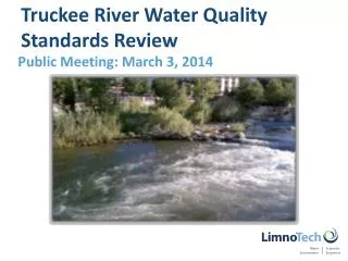
Background on Water Quality Models for the Truckee River WQS Review Process November 2, 2011 Laura Weintraub, Dave Dilks
Overview • Water Quality modeling to support the WQS (water quality standards) review process • Watershed model: • WARMF development and calibration • River water quality model: • TRHSPF development and calibration • Overview of model updates • Intended use of the models
Model Linkage – Observed Conditions Climate Soil Types WWTPs Pollutant Land Use Loads Watershed Water Quality Water • Management Practices Model Model Quality Water Reservoir Releases Quantity WARMF TRHSPF
Model Calibration Process • Certain model parameters cannot be directly measured, and must be indirectly estimated by finding which values allow the model to best describe the observed data • Process is called model calibration • Calibration guidelines • Keep calibration parameters within reasonable range • No single objective measure of model calibration
Compliance with Dissolved Oxygen (DO) Standard is Key Element for Aquatic Life Beneficial Use Sunlight Temperature Flow Dissolved Oxygen Aeration Nutrients (N&P) Organic Matter Algae Truckee River downstream of Lake Tahoe
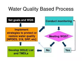
Use of Models in the WQS/TMDL Process WWTPs Climate Nonpoint Loads Land Use Watershed Water Quality Water Model Model Quality Management Practices
Use of Models in the WQS/TMDL Process WWTPs Climate Nonpoint Loads Land Use Watershed Water Quality Water Model Model Quality Management Practices No Adjust Point Sources Meets WQS? or Land Management Practices Yes Done
WARMF: Watershed Model • Peer reviewed, public domain • Predicts watershed flow and pollutant loads based on • land use • meteorological conditions • water management • watershed improvements • 125 catchments (subwatersheds) • Time step = 1 day
Key Processes of WARMF • Driven by meteorology and land use • Simulates nonpoint source loads; point source loads are input • Simulates hydrology, mass balance, acid-base chemistry, erosion / sediment transport, pollutant build-up / wash-off, water quality, algal nutrient dynamics (simplified) • Evaluates changes in nonpoint loading with varying land use, meteorological conditions, water use Subsurface Processes Mineral Weathering AMD Septic Systems Organic Matter Decay Nitrification Cation Exchange Plant Uptake
WARMF Calibration / Application • Model Calibration: 1990-1997 • Model Confirmation / Verification: • 1985-1990 • 1998-2004 • Calibration Report: Systech, 2007. Adaptation of the WARMF Watershed Decision Support System to the Truckee River Basin of California and Nevada, 2007 Calibration Report, Prepared for City of Reno and City of Sparks, NV, Prepared by Systech Engineering, December 2007. • Report available on TRIG
TRHSPF: River Water Quality Model • Long history of HSPF applications in Truckee River (USGS) • Updated to include periphyton based on DSSAMt science • Open code, EPA-supported, peer reviewed • Inputs are flow, watershed loads, point sources • Predicts water quality response of river • nutrients periphyton dissolved oxygen
TRHSPF Model Domain • 43 segments from E. McCarran Blvd to Marble Bluff Dam • Average reach length 1.31 miles • Time step = 0.5 hr
Key Processes Modeled in TRHSPF • Stream hydraulics • Water quality • Temperature, nitrogen, phosphorus, algae, oxygen
Key Processes Modeled in TRHSPF (continued) • Mass transport (Nitrogen, Phosphorus, TDS) • Nutrient dynamics • Productivity (algae growth and decay) • Performed literature review on benthic algae modeling • HSPF Enhancements based on DSAMMt algorithms
TRHSPF Calibration / Application • Model Calibration: July 2000 – August 2002 • Many parameters estimated from data • Concurrent algae biomass and water quality data available for calibration • Acceptable comparison confidence that algorithms can predict benthic algae reasonably well • Model Confirmation / Verification: 1990, 1995, 1996 • Calibration Report: LimnoTech. 2008. Final Draft Calibration of the Truckee River HSPF Water Quality Model. Prepared for the Cities of Reno and Sparks, Nevada, January, 2008. • Report available on TRIG
Truckee River Water Quality Model Updates • Goal: develop best possible tools given reasonable time, information, and funding • Due diligence to ensure models work well for recent time period • Model update steps: • Extended models to run through 12/2008 – updated all databases • Capture changes in loading due to Truckee Meadows development • Conducted model confirmation runs – held model calibration parameters constant • Documenting changes to models and databases, results of model confirmation • Share model information with the focus stakeholder group
Model Database Updates: WARMF Land Use / Land Cover • Old Land Use / Land Cover (LULC) data reflective of late 1990’s • Rapid growth and development through 2006 • New LULC reflective of recent growth • Combination of several datasets • 2006 National Land Cover Dataset (NLCD) – underlying base layer • 2010 Washoe County / Truckee Meadows Regional Planning Agency – developed parcel data supersedes NLCD data • Site-specific additions based on “parks” layer /Google Earth: ski resorts, golf courses, parks, animal feeding operation
New 2006/2007 layer imported to WARMF (increased development)
Evaluation of Linked WARMF/TRHSPF Modeling Framework • Previously used data to drive TRHSPF upstream boundary – now using WARMF results • Comparison of TRHSPF results to data isn’t just evaluation of TRHSPF, but evaluation of linked WARMF/TRHSPF • Allows for modeling of river WQ response based on changes in watershed
Summary of Model Update • Confirmation of WARMF and TRHSPF for 2000-2008 period • Model updated to reflect rapid regional growth through 2006 • Both models are ready for use to support the third-party WQS and TMDL review efforts • Third-parties welcome comments and questions from Focus Stakeholder group • Model confirmation report being finalized
Intended Use of Models for WQS Review • Provide linkage between nutrient loading to the Truckee River and resulting dissolved oxygen levels • Account for other factors (flow, temperature, light, organic matter, aeration) • Understand balance of nutrient concentrations which result in DO WQS attainment under a range of flow conditions
Model Linkage – Observed Conditions Climate Soil Types WWTPs Pollutant Land Use Loads Watershed Water Quality Water • Management Practices Model Model Quality Water Reservoir Releases Quantity WARMF TRHSPF
Model Linkage – Future Conditions Flow Management Model Climate Soil Types WWTPs Pollutant Loads Land Use Watershed Water Quality Water Model Model Quality Management Water Practices Quantity WARMF TRHSPF
Selection of Flow Management Model • Flow management model will provide a mechanism to determine a representative low flow condition with current river operations and historical climate • TROM (Truckee River Operations Model) • Long history of application in Truckee River • Previously coupled with WARMF/TRHSPF for test simulation • RiverWare • Newer model; water accounting version functional • Still under development
Next Technical Steps in WQS Review Process • Finalize model update report; distribute to stakeholders • Solicit feedback from stakeholder group • Construct / run a set of scenario runs • Establish representative low flow • Link flow management model with WQ models • Vary N and P concentrations DO response • Document any recommendations for revised WQS • Submit report to NDEP for WQS Review