
Uploaded by
alta
25 SLIDES
770 VUES
270LIKES
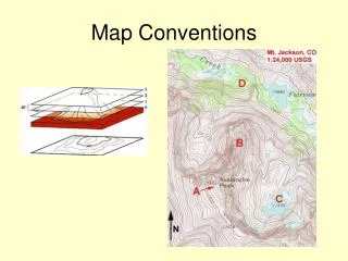
Map Conventions
DESCRIPTION
Map Conventions. Latitude and Longitude. Latitude and Longitude. Latitude and Longitude. Latitude and Longitude. Magnetic Declination. Magnetic Declination. Magnetic Declination. Migration of magnetic north pole. Magnetic Declination. Scale. Using Scale. Using Scale. Topographic Maps.
Download
1 / 25
Download Presentation

Télécharger la présentation
Map Conventions
An Image/Link below is provided (as is) to download presentation
Download Policy: Content on the Website is provided to you AS IS for your information and personal use and may not be sold / licensed / shared on other websites without getting consent from its author.
Content is provided to you AS IS for your information and personal use only.
Download presentation by click this link.
While downloading, if for some reason you are not able to download a presentation, the publisher may have deleted the file from their server.
During download, if you can't get a presentation, the file might be deleted by the publisher.
E N D
Presentation Transcript
Magnetic Declination Migration of magnetic north pole
Topo Maps and Contour Interval What is the contour interval?
Topo Maps and Gradient Note how gradient is reflected in spacing of contour lines. Close together = steep Far apart = minimal slope
Topo Maps and Gradient Calculating gradient Rise over run 1,250 ft/5 miles


More Related
Audio
Live Player