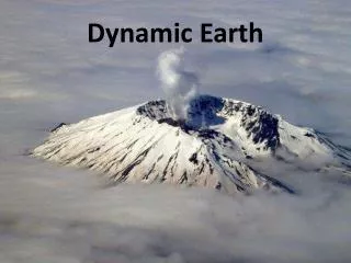
Dynamic Earth
Dynamic Earth. Class 5 24 January 2006. Any Questions?. Interacting Earth Systems Volcanoes contribute gases to the atmosphere . This is how the oceans were formed 3-4 Billion years ago. Lithosphere Hydrosphere Atmosphere Biosphere.

Dynamic Earth
E N D
Presentation Transcript
Dynamic Earth Class 5 24 January 2006
Interacting Earth SystemsVolcanoes contribute gases to the atmosphere. This is how the oceans were formed 3-4 Billion years ago
Lithosphere Hydrosphere Atmosphere Biosphere
Plate Tectonics • Fundamental Concept and Unifying Theory in Earth Science • Idea is > 100 yrs old • Acceptance only within the past 30 years
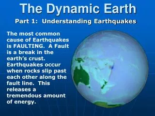
Plate Tectonics • How and why did it come about? • During the 1800’s geologists recognized many strange things that seemed to imply that the continents had once been together.
Early geologists sawsimilarities between the coasts of Africa and South America.
This map from 1858 shows that Africa and South America can be fit together very well.
The fit of the continents 1915: Alfred Wegener Origin of the Continents and Oceans
Fit of the continents Alexander du Toit: Continuity of rocks between Africa and South America
If the northern continents are fit together, rock units match very well.
The same kinds of fossils appear on both sides of the Atlantic(Mesosaurs lived in fresh water)
There is evidence that huge glaciers occupied large parts of the southern continents about 250 million years ago.
This distribution is very difficult to explain if the continents were in this position during the time of glaciation.
But, if we move the continents together, it is easy to explain the glacial evidence.
During the Permian Period (225 Million Years Ago), there was one super continent called Pangea
The Theory of “Continental Drift” proposed that Pangea began to break upin the Triassic (200 Million Years Ago)
Gondwanaland (southern continent) began to break up in the Jurassic Period(135 Million Years Ago)
The south Atlantic opened in the Cretaceous (65 Million Years Ago)
And the continents continued to drift to their Present Day positions
Acceptance of Continental Drift? • Evidence for continental drift purely descriptive • Description is not an explanation • Theory must explain how continents move • No plausible explanation for driving force • Wegener thought that continents floated like boats across the solid ocean crust, dragged along by the tidal forces of the Sun and Moon
Holmes’ explanation of continental drift (1928) Convection deep in the Earth could push and pull the continents apart, creating new oceanic crust through the process of seafloor spreading.
Convection Water boiling in a pan on your stove is an example of convection
Convection Hot water rises Cold water sinks
Holmes’ explanation of continental drift (1928) Holmes’ proposed convection currents “dragged the two halves of the original continents apart, with consequent mountain building in the front where the currents are descending, and the ocean floor development in the site of the gaps, where the currents are ascending.” Holmes’ theory was almost universally ignored because of the influence of Sir Harold Jeffreys… Jeffreys thought the idea crazy! His observations of earthquakes suggested that Earth’s interior far too rigid – as rigid as steel.
Holmes’ explanation of continental drift (1928) Holmes conceded that “purely speculative ideas of this kind, specifically invented to match the requirements, can have no scientific value until they acquire support from independent evidence.”
Why was Continental Drift not accepted? • Because it was difficult to under-stand how continents could move. • What did we learn to make us more willing to accept the idea that the continents have moved?
Jump ahead to the 1960s Maps and paintings by Marie Tharp allowed geologists to visualize the newly available bathymetry
Mid-Atlantic Ridge
Drilling into the seafloor provided more evidence supporting sea-floor spreading • Micropaleontology of sediments • Dating of the underlying lavas Drilling ship Glomar Challenger
But, it is not possible to drill enough holes in the seafloor to produce this map. How was it made? Age of Seafloor Crust
Earth’s Magnetic Field Another key to understanding the puzzle.
Earth’s Magnetic Field The Earth behaves like a magnet whose poles are nearly coincident with the spin axis (i.e., the geographic poles).
Earth’s Magnetic Field Magnetic lines of force emanate from the magnetic poles. A suspended magnet is inclined due to the magnetic field.
A compass points North because theneedle is made of iron. It becomes aligned in the Earth’s magnetic field.
Magma formed at spreading centers contains minute pieces of iron that become aligned in the direction of the Earth’s magnetic field.
When the magma cools, the iron pieces remain frozen in this alignment, pointing toward the Earth’s magnetic North Pole.
Magnetic reversals • A special property of the Earth’s magnetic field is that it has reversed its direction many times in the past. • When this happens, rocks formed at that time are magnetized pointing toward the South Pole.
Magnetic reversals • The last reversal was about 700,000 years ago. • These reversals appear to be abrupt (probably only take about 1000 years or so).
Magnetic reversals • A period of time in which magnetism is dominantly of one polarity is called a magnetic epoch. • We call north polarity normal and south polarity reversed.