Download
1 / 2
20 likes | 169 Vues
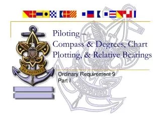
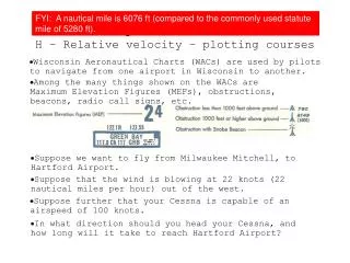
FYI: A nautical mile is 6076 ft (compared to the commonly used statute mile of 5280 ft). Topic 2.1 Extended H – Relative velocity – plotting courses. Wisconsin Aeronautical Charts (WACs) are used by pilots to navigate from one airport in Wisconsin to another.

E N D
FYI: A nautical mile is 6076 ft (compared to the commonly used statute mile of 5280 ft). Topic 2.1 ExtendedH – Relative velocity – plotting courses Wisconsin Aeronautical Charts (WACs) are used by pilots to navigate from one airport in Wisconsin to another. Among the many things shown on the WACs are Maximum Elevation Figures (MEFs), obstructions, beacons, radio call signs, etc. Suppose we want to fly from Milwaukee Mitchell, to Hartford Airport. Suppose that the wind is blowing at 22 knots (22 nautical miles per hour) out of the west. Suppose further that your Cessna is capable of an airspeed of 100 knots. In what direction should you head your Cessna, and how long will it take to reach Hartford Airport?
FYI: Pilots measure angles WRT NORTH. In other words, North is 0°. vPA + vAG = vPG plane equation FYI: Always measure angles WRT PARALLELS or MERIDIANS. ORIGIN: Milwaukee Mitchell DESTINATION: Hartford Airport WIND: 22 kn from west AIRSPEED: 100 kn N = 0° VAG Bearing is 308°. Groundspeed is 83 knots. Distance is 32.5 nm. NORTH / SOUTH REFERENCE MERIDIAN OF LONGITUDE Time is 23 minutes. VPG VPA E = 90° W = 270° PARALLEL OF LATITUDE EAST / WEST REFERENCE S = 180° Find the magnitude of VPG using SAME SCALE: Line up plotter on course. Step 2: With your plotter, draw a scale WIND (VAG): It must BEGIN on the ORIGINAL LINE (the red one). Use any scale you like, but END it at DESTINATION. Place bull's eye on a meridian. STEP 5: Find BEARING of VPA: STEP 4: Draw in VPG: Step 3: With SAME scale, draw VPA: Be sure to use CORRECT SCALE FOR MAP: Step 1: Draw a line through ORIGIN and DESTINATION. The wind, and the destination's bearing. There are two directions we have no control over: Find ACTUAL DISTANCE between ORIGIN and DESTINATION: Bearing should be between 270° and 360°. Now we can calculate the travel time: t = d/VPG... It must END on the Tail if the WIND VECTOR.