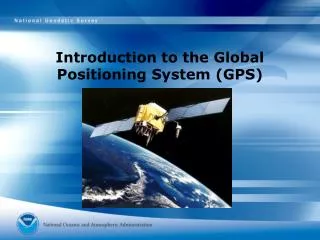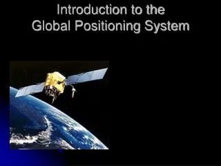
Introduction to Global Positioning System: How GPS Works
210 likes | 246 Vues
Learn about GPS - how it works, its components, satellite system, user interfaces, Ground Control Segment, communication, applications in navigation, timing, and mapping, accuracy levels, and selective availability. Explore GPS technology, classroom applications, careers, and the impact on various industries.

Introduction to Global Positioning System: How GPS Works
E N D
Presentation Transcript
What is the GPS? • Orbiting navigational satellites • Transmit position and time data • Handheld receivers calculate • latitude • longitude • altitude • velocity • Developed by Department of Defense
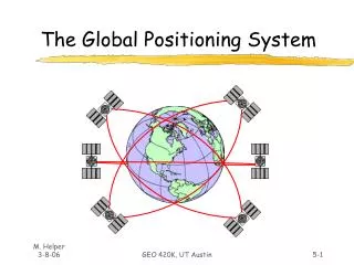
Components of the System Space segment • 24 satellite vehicles • Six orbital planes • Inclined 55o with respect to equator • Orbits separated by 60o • 20,200 km elevation above Earth • Orbital period of 11 hr 55 min • Five to eight satellites visible from any point on Earth Block I Satellite Vehicle
GPS Satellite Vehicle • Weight • 2370 pounds • Height • 16.25 feet • Width • 38.025 feet including wing span • Design life—10 years Block IIR satellite vehicle assembly at Lockheed Martin, Valley Forge, PA
Components of the System User segment • GPS antennas & receiver/processors • Position • Velocity • Precise timing • Used by • Aircraft • Ground vehicles • Ships • Individuals
Components of the System Ground control segment • Master control station • Schreiver AFB, Colorado • Five monitor stations • Three ground antennas • Backup control system
How does GPS work? • Satellite ranging • Satellite locations • Satellite to user distance • Need four satellites to determine position • Distance measurement • Radio signal traveling at speed of light • Measure time from satellite to user • Low-tech simulation
How does GPS work? • Distance to a satellite is determined by measuring how long a radio signal takes to reach us from that satellite. • To make the measurement we assume that both the satellite and our receiver are generating the same pseudo-random codes at exactly the same time. • By comparing how late the satellite's pseudo-random code appears compared to our receiver's code, we determine how long it took to reach us. • Multiply that travel time by the speed of light and you've got distance. • High-tech simulation
How does GPS work? • Accurate timing is the key to measuring distance to satellites. • Satellites are accurate because they have four atomic clocks ($100,000 each) on board. • Receiver clocks don't have to be too accurate because an extra satellite range measurement can remove errors.
How does GPS work? • To use the satellites as references for range measurements we need to know exactly where they are. • GPS satAellites are so high up their orbits are very predictable. • All GPS receivers have an almanac programmed into their computers that tells them where in the sky each satellite is, moment by moment. • Minor variations in their orbits are measured by the Department of Defense. • The error information is sent to the satellites, to be transmitted along with the timing signals.
System Performance • Standard Positioning System • 100 meters horizontal accuracy • 156 meters vertical accuracy • Designed for civilian use • No user fee or restrictions • Precise Positioning System • 22 meters horizontal accuracy • 27.7 meters vertical accuracy • Designed for military use
System Performance Selective availability • Intentional degradation of signal • Controls availability of system’s full capabilities • Set to zero May 2000 • Reasons • Enhanced 911 service • Car navigation • Adoption of GPS time standard • Recreation
System Performance • The earth's ionosphere and atmosphere cause delays in the GPS signal that translate into position errors. • Some errors can be factored out using mathematics and modeling. • The configuration of the satellites in the sky can magnify other errors. • Differential GPS can reduce errors.
Application of GPS Technology • Location - determining a basic position • Navigation - getting from one location to another • Tracking - monitoring the movement of people and things • Mapping - creating maps of the world • Timing - bringing precise timing to the world
Application of GPS Technology • Private and recreation • Traveling by car • Hiking, climbing, biking • Vehicle control • Mapping, survey, geology • English Channel Tunnel • Agriculture • Aviation • General and commercial • Spacecraft • Maritime
Classroom Applications • Physics • Distance, velocity, time • Orbital concepts • Earth Science • Mapping • Spacecraft • Environmental Science • Migratory patterns • Population distributions • GLOBE Program • Mathematics • Geography • Technology
Classroom Applications Careers • Aerospace • Satellite vehicles • Launch vehicles • Hardware engineering • Ground control systems • User systems • Software engineering • Research careers
Conclusion GPS is finding its place in every corner of our life. Today, we find many applications of GPS all around us. Its like giving every square meter on the planet a unique address. In future, the airplanes with GPSRs will be able to land even in dark and in moist conditions. In no time GPS will be a complete part of our life, just as a mobile we have today.