Minimalist Approach to Spatial Allocation: Tools, Design, and Standards
This comprehensive guide emphasizes the importance of a minimalist philosophy in spatial allocation. It outlines the necessary tools for effective design and management of spatial data, including PostgreSQL, PostGIS, and various GIS software. Readers will learn to perform computational intersections, create emission modeling grids, and manage spatial attributes without unnecessary complexity. The document highlights best practices, potential issues, and crucial questions related to map projections and data processing, warning against scope creep and encouraging the use of existing tools rather than developing new solutions.


Minimalist Approach to Spatial Allocation: Tools, Design, and Standards
E N D
Presentation Transcript
Spatial Allocation • Philosophy • Tools • Design • Standard reports • Questions
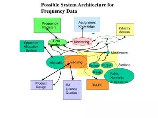
Spatial Allocation (Philosophy) • Design for only the necessary functions • Perform a computational intersection of point, arc, or polygon structures within a polygon structure • Create arbitrary emissions modeling grid structures • Manage and display underlying maps and spatial attributes • Covert among various, common map projections. • Use off-the-shelf shareware/freeware tools • Do not reinvent • Provide hooks for future enhancements • Scope creep will kill this aspect of the project • Bottom-line: take the minimalist approach
Spatial Allocation (Tools) • PostgreSQL -- www.postgresql.org • GNU make – mirrors.usc.edu/pub/gnu/make/ • GNU readline – mirrors.usc.edu/pub/gnu/readline/ • Ant – ant.apache.org/srcdownload.cgi • JAVA – java.sun.com/j2se/ • Perl – www.perl.com/pub/a/language/info/software.html#sourcecode • PostGIS -- postgis.refractions.net • shp2pgsql – ARC shape files to SQL insert constructs • e00ps – ARC export files to SQL insert constructs – e00pg.sourceforge.net • special converters to import BELD3 data will be constructed • MIMS Spatial Allocator -- www.epa.gov/asmdnerl/mims/software/spatial_allocator.html • Java-enabled Unified Mapping Platform (JUMP) -- www.vividsolutions.com/jump • PostGIS JUMP driver – postgis.refractions.net/download.php
Spatial Allocation (Standard Reports) • Map of domain with grid structure overlay • Maps of individual coverages in native and projected coordinates • Gridded maps of BELD3 by species • Gridded maps of individual surrogate fractions • Gridded map of point source locations
Spatial Allocation (Questions) • ARC shape and export files • Shape converter is stable • Export converter may not be so stable (ESRI considers the export format to be proprietary; hence, the converter is based on a reverse engineering approach – the web gossip seems to indicate that it works fine) • Datum in conjunction with non-datum coverages – very difficult to implement (i.e., easiest to use either all datum-based coverages or nondatum-based coverages) • MIMS Spatial Allocator • No need for special C-compiler (GNU C or host C should work fine) • No special license requirements • Noted problems with memory leaks; problems with large (<200 MB) coverages • Special map projections • Standard map projections definitely supported (Lambert Conformal, UTM, geographic, Polar Stereographic) • Special map projections not supported (stateplane [these are specialized projections of standard map projections] e.g. Lambert, transverse, oblique mercator)
Spatial Allocation (Questions – continued) • Geographic Resources Analysis Support System (GRASS) • grass.itc.it • Relatively large overhead (150 MB) • Robust GIS • Use will require new coding to build MIMS functionality • Other shareware/freeware GIS tools • PostGIS itself provides basic GIS functionality • Geometry Engine - Open Source (GEOS) – geos.refractions.net/ • Java Topology Suite (JTS) – www.vividsolutions.com/jts/jtshome.htm • Will need to be coupled to map projection system like Cartographic Projections Library PROJ.4 (www.remotesensing.org/proj/) • These systems provide basic GIS functionality but will require coding to recreate MIMS Spatial Allocator functionality
Spatial Allocation (Questions – continued) • What if any special processing needs to be considered for identifying data associated to tribal lands when the base data (e.g., BELD3) has no such information? • Any such pre- or in-line-processing of the data and the ability of the project team to incorporate such a capability in OPEM has resource implications (i.e., the project team believes that this is an enhancement we can live without at this time)