Download
1 / 1
10 likes | 107 Vues
Building a Traffic Signal and Sign Inventory for the City of Edmond. Christy R. Batterson Information Technology/GIS Team 1273 N Broadway - Edmond, OK 73034 christy.batterson@edmondok.com. Ian M. Peebles Information Technology/GIS Team 1273 N Broadway - Edmond, OK 73034

E N D
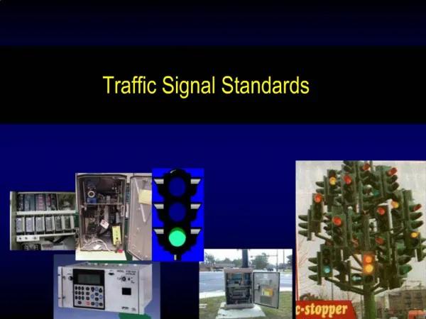
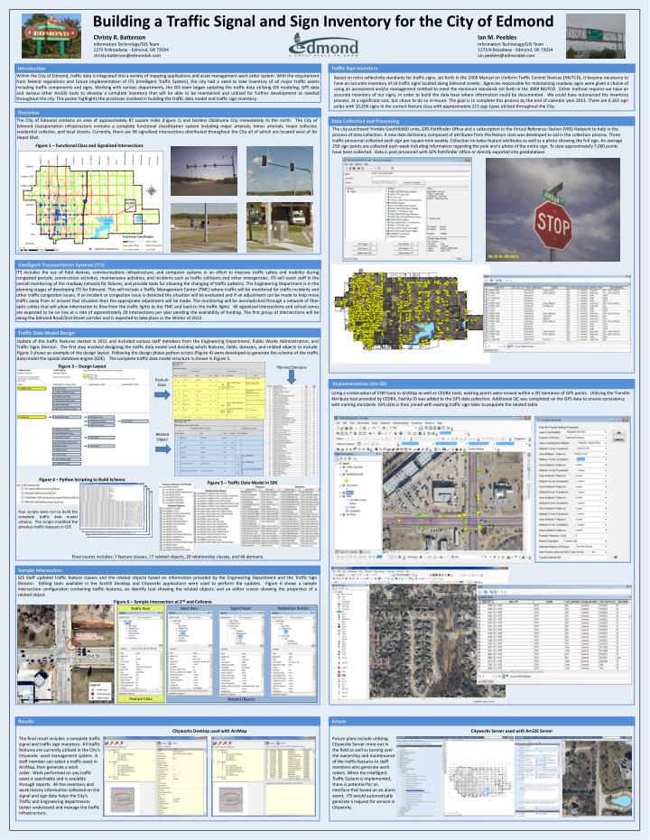
Building a Traffic Signal and Sign Inventory for the City of Edmond Christy R. Batterson Information Technology/GIS Team 1273 N Broadway - Edmond, OK 73034 christy.batterson@edmondok.com Ian M. Peebles Information Technology/GIS Team 1273 N Broadway - Edmond, OK 73034 ian.peebles@edmondok.com Traffic Sign Inventory Introduction Within the City of Edmond, traffic data is integrated into a variety of mapping applications and asset management work order system. With the requirement from federal regulations and future implementation of ITS (Intelligent Traffic System), the city had a need to take inventory of all major traffic assets including traffic components and signs. Working with various departments, the GIS team began updating the traffic data utilizing GIS modeling, GPS data and various other ArcGIS tools to develop a complete inventory that will be able to be maintained and utilized for further development as needed throughout the city. This poster highlights the processes involved in building the traffic data model and traffic sign inventory. Based on retro-reflectivity standards for traffic signs, set forth in the 2009 Manual on Uniform Traffic Control Devices (MUTCD), it became necessary to have an accurate inventory of all traffic signs located along Edmond streets. Agencies responsible for maintaining roadway signs were given a choice of using an assessment and/or management method to meet the minimum standards set forth in the 2009 MUTCD. Either method requires we have an accurate inventory of our signs, in order to build the data base where information could be documented. We could have outsourced the inventory process, at a significant cost, but chose to do so in-house. The goal is to complete this process by the end of calendar year 2013.There are 6,163 sign poles with 10,204 signs in the current feature class with approximately 215 sign types utilized throughout the City. Overview Data Collection and Processing The City of Edmond contains an area of approximately 87 square miles (Figure 1) and borders Oklahoma City immediately to the north. The City of Edmond transportation infrastructure contains a complete functional classification system including major arterials, minor arterials, major collector, residential collector, and local streets. Currently, there are 98 signalized intersections distributed throughout the City all of which are located west of Air Depot Blvd. The city purchased Trimble GeoXH6000 units, GPS Pathfinder Office and a subscription in the Virtual Reference Station (VRS) Network to help in the process of data collection. A new data dictionary composed of attributes from the feature class was developed to aid in the collection process. Three traffic personnel collected each sign per square mile weekly. Collection includes feature attributes as well as a photo showing the full sign. An average 250 sign points are collected each week including information regarding the pole and a photo of the entire sign. To date approximately 7,000 points have been collected. Data is post processed with GPS Pathfinder Office or directly exported into geodatabase. Figure 1 – Functional Class and Signalized Intersections Intelligent Transportation Systems (ITS) ITS includes the use of field devices, communications infrastructure, and computer systems in an effort to improve traffic safety and mobility during congested periods, construction activities, maintenance activities, and incidents such as traffic collisions and other emergencies. ITS will assist staff in the overall monitoring of the roadway network for failures, and provide tools for allowing the changing of traffic patterns. The Engineering Department is in the planning stages of developing ITS for Edmond. This will include a Traffic Management Center (TMC) where traffic will be monitored for traffic incidents and other traffic congestion issues. If an incident or congestion issue is detected the situation will be evaluated and if an adjustment can be made to help move traffic away from or around that situation then the appropriate adjustment will be made. The monitoring will be accomplished through a network of fiber optic cables that will allow information to flow from the traffic lights to the TMC and back to the traffic lights. All signalized intersections and school zones are expected to be on line at a rate of approximately 20 intersections per year pending the availability of funding. The first group of intersections will be along the Edmond Road/2nd Street corridor and is expected to take place in the Winter of 2013. Traffic Data Model Design Update of the traffic features started in 2011 and included various staff members from the Engineering Department, Public Works Administration, and Traffic Signs Division. The first step involved designing the traffic data model and deciding which features, fields, domains, and related objects to include. Figure 3 shows an example of the design layout. Following the design phase python scripts (Figure 4) were developed to generate the schema of the traffic data model the spatial database engine (SDE). The complete traffic data model structure is shown in Figure 5. Planned Domains Figure 3 – Design Layout Feature Class Implementation into GIS Using a combination of ESRI tools in ArcMap as well as CEDRA tools, existing points were moved within a 5ft tolerance of GPS points. Utilizing the Transfer Attribute tool provided by CEDRA, Facility ID was added to the GPS data collection. Additional QC was completed on the GPS data to ensure consistency with naming standards. GPS data is then joined with existing traffic sign table to populate the related table. Related Object Figure 4 – Python Scripting to Build Schema Figure 5 – Traffic Data Model in SDE Four scripts were run to build the complete traffic data model schema. The scripts modified the previous traffic datasets in SDE. Final counts includes: 7 feature classes, 17 related objects, 20 relationship classes, and 46 domains. Sample Intersection GIS Staff updated traffic feature classes and the related objects based on information provided by the Engineering Department and the Traffic Sign Division. Editing tools available in the ArcGIS Desktop and Cityworks applications were used to perform the updates. Figure 6 shows a sample intersection configuration containing traffic features, an identify tool showing the related objects, and an editor screen showing the properties of a related object. Figure 6 – Sample Intersection at 2nd and Coltrane Signal Head Pedestrian Button Mast Arm Traffic Pole Feature Class Related Objects Results Future Cityworks Desktop used with ArcMap Cityworks Server used with ArcGIS Server The final result includes a complete traffic signal and traffic sign inventory. All traffic features are currently utilized in the City’s Cityworks asset management system. A staff member can select a traffic asset in ArcMap, then generate a work order. Work performed on any traffic asset is searchable and is available through reports. All the inventory and work history information collected on the signal and sign data helps the City’s Traffic and Engineering departments better understand and manage the traffic infrastructure. Future plans include utilizing Cityworks Server more out in the field as well as turning over the ownership and maintenance of the traffic features to staff members who generate work orders. When the Intelligent Traffic System is implemented, there is potential for an interface that based on an alarm event, ITS would automatically generate a request for service in Cityworks.