Download
1 / 24
240 likes | 383 Vues
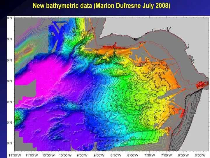
New bathymetric data (Marion Dufresne July 2008). New bathymetric data (Marion Dufresne July 2008). New bathymetric data (Marion Dufresne July 2008). New bathymetric data (Marion Dufresne July 2008). Depth to basement map [MCS and OBS data] (Thiebot and Gutscher, 2006).

E N D
New bathymetric data (Marion Dufresne July 2008)
New bathymetric data (Marion Dufresne July 2008)
Depth to basement map [MCS and OBS data] (Thiebot and Gutscher, 2006)
Sediment thickness map - W of Gibraltar (Gutscher et al., accepted Tectonophys.)
Crustal thickness map [S. Iberia - N. Morocco] (Gutscher et al., accepted Tectonophys.)
Seismicity (29 Aug 2007 - 31 July 2008) (recorded by land stations) SWIM 2008 Cruise Report (L. Matias)
Seismicity (29 Aug 2007 - 31 July 2008) within 75 km of OBS-BB network SWIM 2008 Cruise Report (L. Matias)
Proposed OBS lines P1: - too long / too many deployments, total 36 (thus compromising other lines) [10 OBS in Tagus, 6 on and S of thrust belt, 3 overlap SISMAR OBS] - very deep water (very long recovery time) Tagus 5000m, HAP 4800m, SAP 4200m - little new info on crustal types (except perhaps Tagus) - 50% of line has no seismicity, and is distant from OBS-BB network
Proposed OBS lines P2: - shortest distance between the SW Iberian (continental) margin and the NW Moroccan (continental margin) crossing thin crust of uncertain type - passes along existing high quality MCS profile (pre-stack depth migrated) - crosses Marq. Pombal and the toe of the accretionary wedge (potentially seismogenic structures)
Kinematic reconstruction 195Ma (Sahabi et al., 2004) w. magnetic anomalies (from Verhoef et al., 1991)
Magnetic anomaly maps (Verhoef et al., 1991)
Magnetic anomaly maps Iberian aero-mag map (left) (Verhoef et al., 1991 - below)