Download
1 / 28
280 likes | 460 Vues
Mid-latitude weather Prof. Jeff Gawrych De Anza College. Introduction. Here in the mid-latitudes, day-to-day weather changes are closely linked to moving, synoptic-scale disturbances These are the high and low pressure systems meteorologists often speak of. Bay Area is at ~ 37º N

E N D
Mid-latitude weather Prof. Jeff Gawrych De Anza College
Introduction • Here in the mid-latitudes, day-to-day weather changes are closely linked to moving, synoptic-scale disturbances • These are the high and low pressure systems meteorologists often speak of. • Bay Area is at ~ 37º N • These systems are steered by upper-levels winds (jet streams) • Using observations (such as weather balloons), we can track their development and decay • Unfortunately, coverage is sparse. • No two systems are exactly alike
Scale Time Scale Distance Scale Examples Macroscale -Planetary Weeks to years Westerlies, trade winds -Synoptic Days to weeks Cyclones, anticyclones and hurricanes Mesoscale Minutes to days Land-sea breeze, thunderstorms and tornadoes Microscale Seconds to minutes Turbulence, dust devils and gusts Atmospheric Scales of Motion 500 – 25,000 miles 50 – 3,000 miles 1 – 50 miles < 1 mile
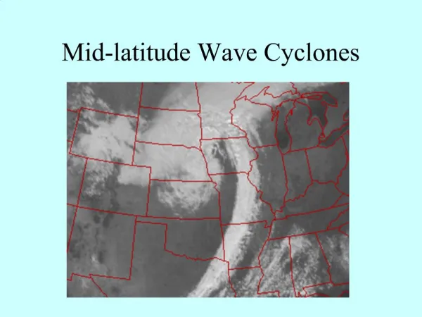
Upper-level flow • Between 500 - 250 mb, or 18,000-36,000 ft • In this portion of the atmosphere, we can most easily see these traveling synoptic events such as: • Cyclones (low pressure systems) • Anticyclones (high pressure systems) • Surface features such as mountains, cities, oceans/land can be misleading • Ben Franklin noted how rain bands do not always travel in the same direction as the large storm system
Low and High pressure systems Cylonic flow Anticylonic flow
Upper air patterns • Aloft, the pressure field normally does not consist of closed high and low pressure contours, it simply flows: • In a general west to east direction • In a wavelike pattern • At upper levels, the pressure field is normally given as the geopotential height. • The geopotential height: • is the height of a particular pressure level. • Consider a 500mb geopotential map. • In this map, the height lines (~5000m) are • physically the same as the surface pressure.
Ridge Trough Trough Trough
Surface flow • At the surface, friction is more important than at upper levels, • thus geostrophic balance is not valid • The result, winds not exactly parallel to isobars, rather angled: • Into low pressure systems • Away from high pressure systems
Friction slows down wind, which decreases coriolis force: Wind now aimed more in direction of PGF.
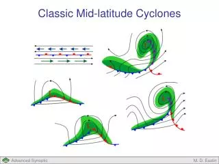
Why do low-pressure systems cause rain? • Aloft: flow is counter clockwise in nh and flow is geostrophic • Surface: flow is ~cc, but NOT geostrophic, • Instead flow is inward towards low causing convergence • Leads to clouds/rain • convergence divergence image
Why do high-pressure systems cause clear conditions? • Aloft: flow is clockwise in nh and geostrophic • Surface: flow is ~clockwise but NOT geostrophic • Instead flow is outward from high causing divergence • Leads to sinking motion (subsidence) and clear skies • What happens to air that sinks???
Air Masses • A general description of the atmosphere over a certain area. • Tells temperature and moisture profile. • Examples cT: continental tropical (warm and moist) cP: continental polar (cold and dry) mT: marine tropical ( warm and moist) mP: marine polar (cold and moist)
Air masses • Type of air mass over a region tells what weather may be like. • Name of air masses tells you where it originated • Air masses originate in specific areas and can dominate the climate. • Remember: climate is what you expect, weather is what you get.
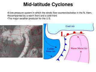
Fronts • Separate different air masses of different densities. Cold air is more dense than warm aircold air sinks, warm air rises. So when a cold front passes, it forces lifting. • Cold fronts bring cold air into region • Warm fronts bring warm air into region
Cold Front Warm front
Temperature advection • Wind direction can be good indicator of temperature change. N. Hem: Wind from the north generally indicates cool air approaching. (cold advection) Wind from the south generally indicated warm air approaching. (warm advection)