Download
1 / 26
380 likes | 849 Vues
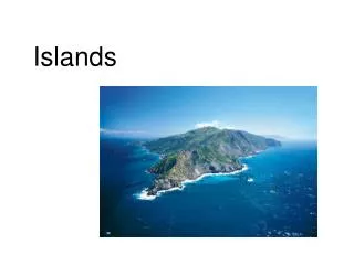
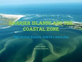
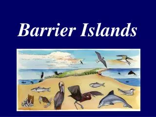
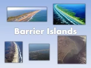
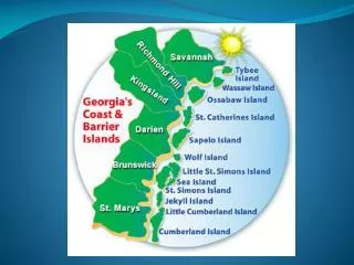
Barrier Islands. long, narrow deposits of sand that form parallel to the shore and away from surf action Found all over the world, but are most well known along the entire eastern coast of North America. Changes. From Florida northward to Maine, they change dramatically in character.

E N D
Barrier Islands • long, narrow deposits of sand that form parallel to the shore and away from surf action • Found all over the world, but are most well known along the entire eastern coast of North America
Changes • From Florida northward to Maine, they change dramatically in character. • Usually separated from the mainland by a lagoon, bay, or sound.
Weather • Although they are hot spots for vacationing and development, because of their geological past these islands are also susceptible to radical changes, especially from intense weather systems, such as hurricanes and nor’easters that run up the coast.
Debate Over Formation • The formation of barrier islands is a much debated subject in geology. • One theory is that the islands were formed about 18,000 years ago as the ice ages ended. As sea level began to rise, it flooded areas behind beach ridges; the rising water also carried the sediments from the beach, depositing it just off the coast. Ocean currents and waves, along with sediment from nearby rivers and streams, continued to bring in sediment, all of which helped to build up the islands.
Changing • Continually changing as the powerful forces of winds, ocean currents, waves, storms and tides reshape them. • Tides have the greatest impact on the evolution of the barrier islands.
Georgia Coastline • The eastern coastline of Georgia is the western end of a massive ocean funnel. • Thus tides here rise higher (6'-8') and faster than anywhere else on the seaboard.
Tybee Island • Farthest north of Georgia’s barrier islands • Approximately 4 miles long and 1 mile wide • Built by sands brought in by the Savannah River • Tybee = an Indian word meaning salt. • Georgia’s most developed barrier island
Little Tybee Island • Once privately owned • Approximately 3 ½ miles of beach with a total acreage of 6,505 acres • The only access to the island is by private boat and as yet there is no development.
Williamson Island • Known as Georgia’s newest island, Williamson Island was first detected around 1971 • Formed by the growth of a sand bar or detached spit off the south end of Little Tybee and the sand is thought to have come from the erosion of Tybee. • Current length is approximately 2 miles. • Named for Mr. Jimmy Williamson, a former Mayor of Darien, Georgia.
Wassaw Island • 7-mile-long island • The most primitive and undeveloped of Georgia’s barrier islands. • In 1866, a New England cotton merchant, George Parson, purchased the island for $2,500. • Later, Parson’s descendants sold it to the Nature Conservancy with the understanding that no bridge would ever be built to it from the mainland. • Research on population levels and habits of loggerhead turtles
Ossabaw Island • 10 miles long and 2 miles wide with an area of 25,000 total acres • 9 ½ miles of beaches • Rich in history and was once a favorite hunting and fishing ground of the Indians. • Skeletal remains of Indians dating back 4,000 years have been found there.
St. Catherine’s Island • 23-square-mile island with a total acreage of 14,640 acres and 11 miles of natural beaches. • Once the capital of the Guale Indian Nation, St. Catherines was also the site of Santa Catalina de Guale, the first Spanish mission in coastal Georgia (1566).
Blackbeard Island • Total acreage including marsh is 5,618 acres. 2 ½ miles wide at its widest point • In the early 1700’s Edward Teach, the famous English pirate popularly known as “Blackbeard,” was thought to have buried treasure here. • In 1800, Blackbeard Island waspurchased by the U. S. Navy Department at public auctionas a source of live oak lumber for shipbuilding. • From August 14, 1880 to 1910, the island served as a quarantine station where ships left passengers that were thought to have yellow fever. • In 1924, became a preserve and breeding ground for native birds
Sapelo Island • 12 miles long and 2 – 4 miles wide with a total area of 17,950 acres • 4th largest of Georgia's barrier islands. • Most extensive undisturbed natural beach dunes of any of Georgia’s barrier islands.
Wolf Island • Located just south of Sapelo at the mouth of the Altamaha River. • 5,126 acres, of which 3 ½ miles of beach line the ocean side of the island. • Access to the island is by boat • Nesting grounds of the terns, shorebirds, wading birds, migratory waterfowl and loggerhead turtles.
Little St. Simons Island • Last family-owned island on Georgia’s coast. • One of its most famous owners was Pierce Butler and his wife Fanny Kemble, who grew rice there during Georgia’s plantation days.
Sea Island • Connected by causeway to St. Simons Island • Privately owned beach resort with hotels and private cottages and residences. • First-class resort -- The Cloister Hotel • Because of its private ownership, there is no public access to the beach from the mainland.
St. Simons Island • Only one of Georgia’s larger barrier islands that has never been privately owned. • Consists of 27,300 total acres including the marsh. • First inhabited by the Creek Indians and then by the Spanish, British, and finally by southern plantation owners who grew sea island cotton and live oak timber. • Lighthouse -- one of the nation's oldest continuously working lighthouses.
Jekyll Island • Smallest of Georgia’s major barrier islands • 10 miles long and 1 ½ miles wide at its widest point • first used as hunting and fishing grounds by the Creek Indians who called the island “Ospo.”
Little Cumberland Island • Owned by a private homeowners association. • 2 ½ miles of beach and 2,400 total acres.
Cumberland Island • Southernmost and longest of Georgia’s barrier islands. • Including the marsh, it has a total acreage of 23,000 acres, 15,000 of which are uplands. • Once inhabited by a Florida tribe of the Timucuan Indians who called the island Missoe which means sassafras. • Island was renamed San Pedro by the Spanish who settled, set up a mission and occupied the island for more than a century. • Named Cumberland in 1734 by Chief Tomochichi in honor of his friend William Augustus, Duke of