Download
1 / 24
240 likes | 275 Vues
Explore the significance of the 20oC isotherm and thermocline zone in ocean climatology. Learn about seasonal changes, upper ocean dynamics, and the annual cycle of temperature variations.

E N D
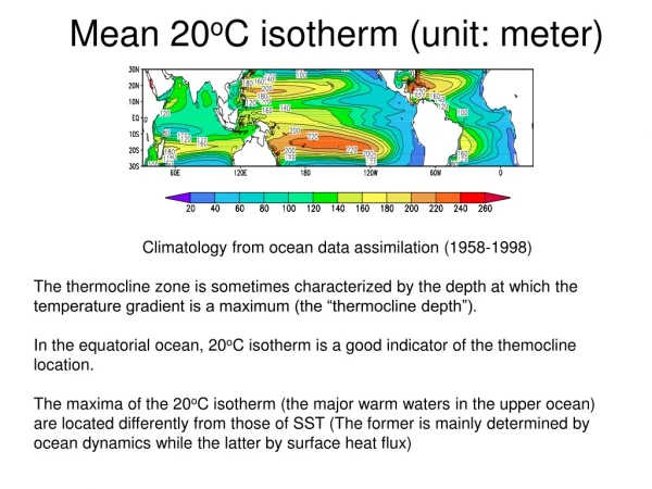
Mean 20oC isotherm (unit: meter) Climatology from ocean data assimilation (1958-1998) The thermocline zone is sometimes characterized by the depth at which the temperature gradient is a maximum (the “thermocline depth”).In the equatorial ocean, 20oC isotherm is a good indicator of the themocline location.The maxima of the 20oC isotherm (the major warm waters in the upper ocean) are located differently from those of SST (The former is mainly determined by ocean dynamics while the latter by surface heat flux)
Seasonal Change in the Upper Ocean (The Annual Cycle)
● Amplitude Equator: 1o-2oC Mid-latitudes (40o): 5o-10oC Poleward: Reduced (melting and freezing of sea ice) Coastal region: 10o-20oC ● Evolution Northern hemisphere Maximum SST: August/September Minimum SST: February/March Sub surface: Delayed up to 2 months. ● Annual cycle decreases rapidly with depth: confined mostly above 100 little change below 200 meters SST Annual Cycle Departure of monthly climatology from climatological annual mean (based on CPC data, 1982-2001)
Annual cycle of temperature in the upper layer Mixed layer: In winter, SST is low, wind waves are large), mixed layer is deep (extending to the main thermocline). In summer, (SST highwater stable), misxed layer is shallow. Seasonal thermocline: seasonal thermocline develops in the upper zone in summer. high stability within the seasonal thermocline separate the water from upper to deeper zones causing a “fossilized mixing zone” (water from remaining winter mixed layer) Example: Seasonal thermocline at Ocean Weather Station “P” (50oN, 145oW) March is nearly isothermal in upper 100 meters. March-August, SST increases, (absorption of solar radiation). Mixed layer 30 m. August-March, net loss of heat, seasonal thermocline eroding due to mixing.
Seasonal change of temperature profiles at different latitudes
Temperature diurnal cycle • SST diurnal cycle: usually small(<0.4oC) • Diurnal cycle is mainly in upper 10 meters • Produce a “diurnal thermocline” • Localized higher amplitude: 1oC (occasionally 3o-4oC) in regions of high isolation + low wind, 2~3oC in shallow water along coast.
Seasonal Cycle of the Thermocline at Equatorial Atlantic Ocean
Fluctuations of the equatorial undercurrent and thermocline depth during 1981-1983
December,1997-February, 1998 20oC isotherm anomalies (m) COLA ODA SSH anomalies (cm) TOPEX/Poseidon
And not just the tropics Image courtesy of Stepen Hare and Nathan Mantua, University of Washington, units are degrees Celsius The Pacific Decadal Oscillation (PDO) is a long-term ocean fluctuation of the Pacific Ocean. The PDO waxes and wanes approximately every 20 to 30 years.