Raster Data
Raster Data. Chapter 7. Introduction. Vector – discrete Raster – continuous Continuous precipitation elevation soil erosion Regular grid cell with value to correspond to the characteristics of the phenomenon. Introduction. Most GIS have both raster and vector


Raster Data
E N D
Presentation Transcript
Raster Data Chapter 7
Introduction • Vector – discrete • Raster – continuous • Continuous • precipitation • elevation • soil erosion • Regular grid cell with value to correspond to the characteristics of the phenomenon
Introduction • Most GIS have both raster and vector • We’ve talked about the data • Data • digital elevation • satellite images • digital orthophotos • scanned maps • graphic files
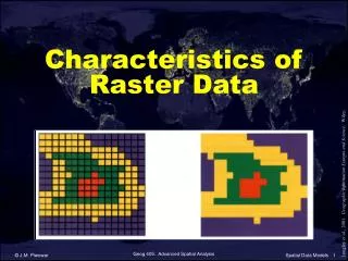
Elements of Raster Data Model • Grid, raster map, surface cover, or image • Rows and columns with cells • Origin at upper left, 2 dimensional coordinate system • Value = integer or floating point • Usually codes for interpretation • No use for DBMS because grid is both spatial and attribute data
Elements of Raster Data Model • Can have value = “pointer” • Cell size determines resolution • Size vs resolution • Projected on coordinate system • Can be displayed with vector if in same coordinate system • Easier to do data manipulation, aggregation and analysis
Types of Raster Data • Satellite Imagery • remotely sensed • Landsat multispectral, 79 meters, ’72-’92 • Landsat 4, Thematic Mapper, 30 meters, • National Oceanic and Atmospheric Administration (NOAA) Advanced Very High Resolution Radiometer (AVHRR) • French SPOT 1986 • India, Japan
Types of Raster Data • Satellite Imagery • Commercial • Space Imaging 1 meter • Earth Watch Incorporated • Image Processing Packages • ERDAS • ER Mapper • ArcView
Digital Elevation Models • DEM is point based with elevation at center of a cell. • Each file contains • Elevation, • Header: units, min/max elev, proj, accuracy • Four types • 7.5 minute DEM (30 or 10 meter elev, 4 levels) • 30 minute DEM (60 meter) • 1 degree DEM (100 meter) • Alaska DEMs
Digital Elevation Models • Non-USGS DEMS • SPOT • Intermap Technologies (5-10 m x 2-5 m) • Global DEMs • GTOPO30 • ETPOPO5
Digital Orthophotos • Digital Orthophoto Quad • Georeferenced • 3.7 minute DOQQ 1m x 1m • Combines image characteristics of a photograph with the geometric qualities of a map. • Ideal background
Other • Binary scanned files • Digital Raster Graphics (DRG) 8 ft • Graphic • TIFF • GIF • JPEG • GeoTIFF • Proprietary: grids or raster maps
Raster Data Structure, Compression, and Files • Data Structure • Cell-by-cell encoding • Band interleaved (.bil) • Band sequential (.bsq) • Band interleaved by pixel (.bip) • Run-length encoding (.rle • Chain code • Block code • Quadtree
Raster Data Structure, Compression, and Files • Data compression • Algorithms • Lossless or lossy • MrSID • Raster Data Files • Need header information
Projection and Geometric Transformation of Raster Data • Raster must also be geo-referenced. • Transformation techniques similar to vector • Ground control points required • Warping • Resampling • Nearest neighbor • Bilinear interpolation • Cubic convolution
Data Conversion • Rasterization • Vectoriation • Loss?
Integration of Raster and Vector Data • Raster usually background • Many techniques • Draping for 3-D effects