Download
1 / 24
260 likes | 414 Vues
Spatial Data and Analysis in Support of Improved Policy and Planning. Christopher Auricht / John Dixon ACIAR Canberra 21 June 2012. Talk outline. Context and Background Needs Issues and status of spatial data

E N D
Spatial Data and Analysis in Support of Improved Policy and Planning Christopher Auricht / John Dixon ACIAR Canberra 21 June 2012
Talk outline • Context and Background • Needs • Issues and status of spatial data • Methodology used in developing an updated farming systems dataset and analysis for Sub-Saharan Africa • Status and future work
Facts • According to CGIAR analysis • One billion of the worlds poor within Africa and Asia (those living on less than $1 per day) are fed primarily by: • hundreds of millions of small-holder farmers (most with less than 2 ha of land, several crops, and a cow or two), or • Herders (most with fewer than five large animals) Solution ? • Develop sustainable farming systems that improve efficiency gains to produce increased food production without using more land, water or other inputs
Scale of Rural Hunger Trends in maize shortage in Zambia Percentage of farm households with maize shortage • Nearly one billion people experience debilitation, health-threatening hunger each year • 4 out of 5 of these people are rural farmers The Hunger Period
Population density and underweight children under five Sources: CIESIN and Hunger Task Force (A and B, unpublished data) And GAEZ database
Background • Business as usual investments in agriculture unlikely to deliver sustainable solutions in many countries • Numerous issues often identified as barriers to progress e.g. inefficiencies in program delivery, political uncertainty etc. These are not the only problem! • Existing systems (often under stress) have been, and are expected to continue to accommodate large increases in population, increasing urbanisation, rising demand for animal products and competition for land and water • Forecasts suggesting that current practices will not stay abreast with population growth, environmental change and increasing demand for animal products.
Needs • Requires a strategic approach, an appreciation of scale, and an understanding of the interactions between and within systems
The current ACIAR project www.fao.org/farmingsystems/ • Builds on the work of Dixon et al 2001
2001 Farming Systems and Poverty • Global study – part of the World Bank Rural Sector Review • Widely accepted as pioneering body of work • Been extensively used to guide investment at the program level. • Approach focused on high level farming systems within six developing regions • Involved use of various thematic data layers to underpin the delineation, characterisation / description and subsequent analysis of systems • Supplemented by expert opinion
Sub-Saharan Update • Farming systems website in FAO still one of the most visited sites within the organisation • Previous study 10 years old • Consistent seamless datasets somewhat limited in original work • In need of updating as spatial extent of systems and frame conditions changed e.g. population, urbanisation etc. • Many updated and new datasets available
Current Situation • 2012 – Large quantity of potential datasets – approx. 300 alone in the Harvest Choice database longitudinal and some predictive data now available • GAEZ 3.0 - 1,000’s of thematic datasets representing 100’s of layers • Challenge – which ones to use and how • Strategic approach • Access and collation • Assess (fit-for-purpose) and Prioritise (currency, coverage, scale etc) • Process • Disseminate
Methodology Delineate new Farming System Boundaries – Iterative process based on concept of central tendancy • Work in collaborative fashion with authors and other large data providers e.g. IFPRI – Harvest Choice, UN-FAO, ILRI, ICRAF, IIASA, CGIAR others . • Characterise and describe systems Spatial and Tabular Data Statistics and Analysis
Current Status • Draft Farming System Boundaries • Material for thematic areas covering • Population time-series avail for rural, urban and total • Poverty $2.00 and $1.25 /day • Environment – LGP, Rainfall, Elevation, Major Envt Constraints, Slope, Satellite Imagery • Livestock • Crops (major crops) • Irrigation • Time to market • Yield gap
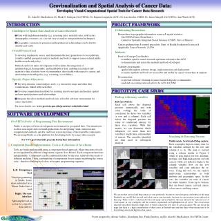
Hunger, Poverty & Productivity Spatial Covariates/Proxies & Analytical Flow Terrain, Demography, Infrastructure, Admin Units Production Environment & Constraints Production Systems & Performance Linkage to Macro Models Interventions/ Responses Crop Distribution & Yields Settlements, ports, markets Crop Suitability: Rainfed Wheat Agroecological Zones Port travel times & costs Market travel times & costs Slope, aspect, drainage Road, rail, river, ICT networks Elevation Administrative Units Yield Responses to Inputs, Management, CC Drought Incidence & Severity Runoff Pests & Diseases (Maize Stem Borer) Cropland extent & intensity Farming Systems Value of Production per Rural Person Profitability of small scale irrigation Quantity of Nutrients Removed Aggregate to FPUs Fertilizer Profitability Distribution of Welfare Benefits Source: HarvestChoice 2010
Issues • Agreed work flow and dissemination Google space • What spatial and analytical products are needed • Sub-system and sub-regional analysis (new boundaries and analysis) • Other data • Climate change • Access to groundwater • Protected areas • Satellite derived products – LGP, Land-use • Incorporation of gap yield datasets
Thanks • Acknowledgements • ACIAR • IFPRI – Harvest Choice • CGIAR • ILRI • ICRAF • FAO • IIASA • others • Questions & Discussion