Air Masses
440 likes | 1.04k Vues
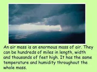
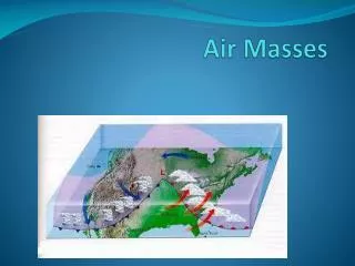
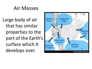
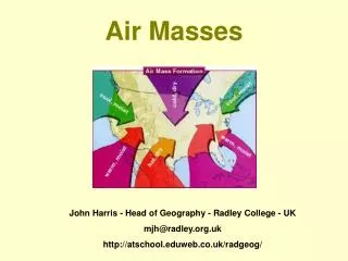
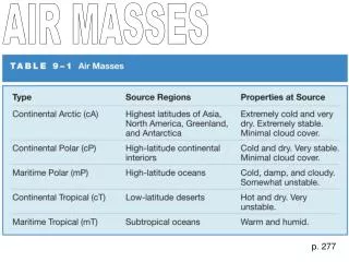
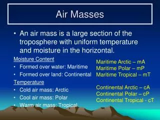
Air Masses. An air mass is a large section of the troposphere with uniform temperature and moisture in the horizontal. Moisture Content Formed over water: Maritime Formed over land: Continental Temperature Cold air mass: Arctic Cool air mass: Polar Warm air mass: Tropical.

Air Masses
E N D
Presentation Transcript
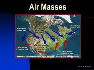
Air Masses • An air mass is a large section of the troposphere with uniform temperature and moisture in the horizontal. Moisture Content • Formed over water: Maritime • Formed over land: Continental Temperature • Cold air mass: Arctic • Cool air mass: Polar • Warm air mass: Tropical Maritime Arctic – mA Maritime Polar – mP Maritime Tropical – mT Continental Arctic – cA Continental Polar – cP Continental Tropical - cT
Areas of Air Mass Formation • Air mass type is determined by the area over which the air has stagnated.
Air Mass Movement and Modification • Air masses can move from their formation zone by advection (wind) and be modified by temperature or water content. • The transition takes place slowly and it can take days to weeks before the entire air mass is transformed.
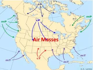
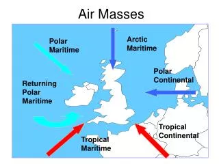
Air Masses of Canada • Continental Arctic: cA • not in summer; low water content; warmed from below, strong winds produce turbulence; heap clouds and snow showers; rarely in B.C. except as a cold-air invasion • (Continental Polar: cP) not according to Air Command Weather Manual • Maritime Arctic: mA • starts as cA that spends some time over the northern Pacific ocean; moist and unstable at high altitudes; stratocumulus and cumulus; pe/sn/-shra; Summer: northern lakes affect air mass • Maritime Polar: mP • more time spent over Pacific ocean; warmer in lower levels; more stable than mA; orographic lifting makes rain west of mountains and dry east of mountains; Summer: Tsra/Cb • Maritime Tropical: mT • very warm and moist; Gulf of Mexico, Caribbean & south of 30°N; Winter: rarely at surface N of Great lakes, but present at high altitudes; unstable when Frontal lift; sn/ra/zr/icing and turbulence; FOG (east coast); Summer: shra/tsra
FRONTS vs AIR MASSES Winter: mT moves far south and Canada generally only sees Continental arctic front and maritime arctic front. Summer: cA moves far north (or disappears) and we only see Maritime Arctic front or Maritime Polar front (ARTIC FRONT) (Maritime Front) (POLAR FRONT)
mT mP mA cA TROPOPAUSE Pg 6-7
POLARFRONTS The transition zone between two air masses is called a front.
Fronts • Named by the movement of the cold air: • Cold Front: that portion of the front where the cold air is advancing • Warm Front: that portion of the front where the cold air is retreating • Stationary Front: the cold air is neither advancing nor retreating. • Occluded Fronts and Trowals: trough of warm air aloft.
Formation of Fronts • Fronts are always located in troughs of low pressure between two different air masses. H 1. H 2. 3.
Speed of Fronts • The speed of the front is equal to the component of the geostrophic wind (parallel to isobars) in the cold air mass that is perpendicular to the front. 20 kts 15 kts 25 kts 10 kts
Cold Fronts • Has a relatively steep frontal slope • Tends to lift the warm air up (like a wedge) • Clouds are of the vertical development category. Cu, TCu, Acc, Cb • Showery precipitation is likely near the front.
The Cold Front Factors: moisture of the warm air mass stability of the warm air mass speed and steepness of the frontal surface Wind: veers, some gusts Temperature: drops Visibility: improves after passage Pressure: approaching front, pressure will drop, then rise after passage Turbulence: usually associated with Cb’s Severe Cb’s can spawn tornados and hail Precipitation: showery in character, usually a narrow band 50 n.m. Cold Warm
Warm Fronts Warm air mass is stable • Has a relatively shallow frontal slope. • Warm air overruns the cold air mass (moves up slope) • Clouds gradually change from Ci, to Cs, to As, to St and Ns as the front approaches. • Continuous precipitation is likely within 400 miles of the front.
Embedded Thunderstorms • If the warm air mass is moist and unstable thunderstorms can form within the normal clouds associated with the warm front. Embedded Cb Warm air mass is unstable
The Warm Front Factors: Moisture Degree of overrunning Stability Wind: Veers Frontal Slope: 1 in 150 to 1 in 200 Temperature: gradual rise Visibility: low ceiling and low visibility; fog Pressure: drop, then rise Turbulence: usually little Precipitation: steady precipitation CI, CS, AS, NS Warm Cold
Winter Warm Front = Freezing Rain! If you encounter ice pellets, the freezing rain is above you and ahead of you in the direction of the front. KaBoom
Frontal Slopes • The slope of a warm front is approximately 1:200 (meaning it rises 1 foot vertically for every 200 feet horizontally) • The slope of a cold front is between 1:50 to 1:100 depening on the speed of the front. • A very fast moving cold front may have a vertical slope in the lower thousand feet causing severe weather due to rapid uplifting of the warm airmass. Warm Front Normal Cold Front Fast moving Cold Front
WIND SHEAR @ WARM FRONT Airplanes in flight will cross the front in advance of a warm front and behind a cold front (when the fronts are depicted at their surface positions).
Frontogenesis and Frontolysis Frontogenesis – The formation or strengthening of a front Frontolysis – The dissipation or weakening of a front Little graves!
7-16 Frontogenesis and 7-18 Frontolysis 1 2 4 3 5 6
FRONTAL WAVE Warm sector high level wind TROWAL / (OCCLUSION) Cold sector upper wind Warm sector upper wind Cold sector surface wind Warm sector surface wind
Warm Colder Cold Warm Colder Cold Warm OCCLUSION or Occluded Front Cold Colder
Frontal Passage • Temperature: Temperature will tend to rise after a warm front passes and fall after a cold front passes. (there are always exceptions to these rules). • Dew point: Will rise after warm front passes and fall after cold front passes. • Visibilities: visibility often improves with the passage of a cold front.
992 L 996 1008 1000 1004 Warm Front Passage (Pressure and Winds) Winds: 270/25 Pressure: 998 mb Winds: 170/20 Pressure: 1001 mb Winds: 230/22 Pressure: 995 mb Winds: 170/20 Pressure: 1010 mb Pressure: falls as the front approaches and rises after it passes Winds: always veer after the front passes
L 994 996 1000 1004 1008 Cold Front Passage Winds: 270/25 Pressure: 1009 mb Winds: 270/25 Pressure: 1002 mb Winds: 020/25 Pressure: 1000 mb Winds: 340/25G35 Pressure: 995 mb Pressure and Winds Pressure: falls as the front approaches and rises after it passes Winds: always veer after the front passes (Gusty winds when the front passes)
JET STREAM Pg 12-13 Pg 12-11
Jet Streams • Rapidly flowing streams of air embedded within the main airflow. • Usually thousands of miles long, a few hundred miles wide, and a few thousand feet thick. • Minimum wind speed to qualify as a Jet is 60 knots.
Jet Streams and Fronts • Jet Streams roughly follow frontal waves. • Temperatures to the north of a jet stream will be colder. (and warmer to the south)
JET STREAM
Jet Stream Turbulence (CAT) • Looking at the jet from west to east (looking downwind), this shows the most turbulent areas.
Low Level Nocturnal Jet Summer, often over the prairies on clear night. Sheet of wind 700 to 2000 agl begins about dusk and peaks in early morning. Wind shear is major problem. Speeds excessive for isobar spacing. 40-65 KNOTS Pg 11-13