Download

1 / 15
150 likes | 177 Vues
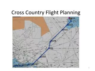
Get prepared for cross-country flying with Sergio's weather check. Learn about thermal updraft velocity, critical updraft height, BL wind, and more. Check the forecast for the Sierra and be ready to go with a landout kit. Prioritize flying areas and plan your routes accordingly.

E N D
Check The Weather During The Week • Thermal updraft velocity • Critical Updraft Height • BL Wind • Cu Cloudbase for Cupot > 0 • Cu potential • CAPE • Total Cloud Cover
Rating The Forecast For The Sierra: • Booming day? 25% chance it is true • Good day? 70% true • Average day? 80% true • Bad day? 60% true • Awful day due to poor conditions? 50% true • Awful day due to thunderstorms? 70% true • Awful day due to wind? 80% true (but good for wave)
Be Prepared To Go • Weather could be substantially better than forecasted • Weather could improve during the day • Have a number of tasks that you would like to do
Be Prepared for Landouts • Extra water • Extra cash • Jacket, with hood, large pockets • Landout kit with: All-weather Poncho Leatherman Multi-Tools Band Aid, Tylenol Pencil/pen Eyeglasses
Aim To Start Early • Possibly assemble the night before • Have everything ready in a bag the night before • Wake up early, try to be ready to fly at 10:00 AM • Check the weather. Check the trigger temperature. • Ask conditions to the tow pilot. • Look around for signs of lift, soaring birds, clouds. • Take off early. Those extra 30 minutes in the morning will be precious in the evening coming back.
Prioritize Flying AreasFor Frequency 1– East (Central Nevada, Austin). 10% Freq. 2 – North East (Winnemucca). 15% Frequency 3 – South (Sierra). 20% Frequency 4 – North (Susanville, Lassen). 30% Freq. 5 – South East (Hilton, Bishop). 80% Freq.** ** It does not add up to 100% since to the south is flyable on most days
Going North To Lassen Pk Red - Cross the valley toward Nervino, get to the ridge east of Quincy, then the ridge east of Greenville, continue east of Lake Almanor. Frequency: 40% of the times. Brown - Go to Adams Pk, follow the ridge to west of Susanville. Frequency: 35%. Blue - Go west to the Sierra, continue on the Sierra to Graeagle, then cut to the ridge east of Quincy. Frequency: 12%. Green – From Quincy East pass west of Lake Almanor. Frequency: 10%. Green – From Graeagle continue west of Lake Almanor. Frequency: 3%.
North To Cedarville and the Oregon Border Red - Go to Adams Pk, follow the ridge to Susanville, then direct towards the ridge west of Eagleville. Frequency: 90% of the times. Green - Or, Go to Air Sailing, Virginia Mtns, then north. Frequency: 10% of the times.
Going North East to Derby, Winnemucca Red - From Mt Rose cross to the hills of Virginia City, follow the ridge towards Tiger A/P, cross to the line of mountains north of Hwy 80 to about Rye Patch Res., then cross to the Star Peak ridge. Frequency: 50%. Green - Or, From Verdi Peak go to Air Sailing, cross to the mountains north of Hwy 80. Frequency: 40%. Blue - Or, go to Air Sailing, Virginia Mtns, Sulphur. Frequency: 10%.
Going East to Central Nevada Red - Go to Mt. Grant, then continue on the hills north of the large valley east of Hawtorne, then to Gabbs.
Southeast to Hilton, Boundary Pk Red - Go to the Pine Nuts, then to Patterson, then the Potato Pk range, and then Boundary Pk. Frequency: 45%. Green - Or, from the Pine Nuts go to the Sweetwater Range, then to the Mt Grant range. Frequency: 55%.
Going South To The Sierra Red - Go to Mt Patterson, then cross to the Sierra. Freq. 30%. Thick Green - Go to Mt Rose and cross to the Pine Nuts. At their south end, cross toward the Sierra. Frequency 25%. Thin Green - Go to the Sierra and pass to the west of Lake Tahoe. Continue all the way to Mt. Whitney. Frequency 20%. Blue - Or, from Patterson go to Potato Pk, then cross to the Sierra. 10%. Blue – Or, from Mt Rose pass on the ridge east of Lake Tahoe. Frequency 10%.
Back to Truckee from the North Red - From Adams Pk cross to bowl on the ridge east of Loyalton, then continue to Verdi Pk Green - From around Air Sailing, get to the Dogskins, then Peavine, then Verdi Pk
Back to Truckee from the South Red - Go to the south end of the Pine Nuts (Bald Mtn). Get to final glide altitude, add 1,000’. Thick Green - If not, try to get inside the Lake Tahoe basin and reach the Elevator. Thin Green - Or, go to Air Sailing, then Peavine, then Verdi Pk. Blue - Or Pond Pk, then the towers of Pah Rah Range.