Visualization
Explore MARS services for creating shapefiles, raster files, and legends in GIS software. Learn to use custom viewers for weather and yield data with spatial analysis capabilities. Access large datasets and perform crop indicator simulations with an online viewer.

Visualization
E N D
Presentation Transcript
Visualization Hendrik Boogaard & Raymond van der Wijngaart
Context Manual: ArcGis / FME / QGIS Custom build viewers: marsop viewers
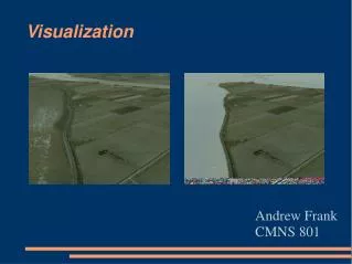
Manual visualization Create schape-files or raster by joining results with grid or administrative regions. Open files in GIS software (ArcGis / QGIS) GRID_WEATHER_*.shp GRID_YIELD_*.shp Create legend with graduate colours
Custom build viewers Operational MARS services deliver and store large amounts of basic and added value data Basic: weather data and RS based VI Added value data generated in the various operational levels of the MARS services through: Downscaling, aggregation Simulation of crop indicators (integrate meteo, soil, crop) Online viewer enables user to perform spatial and temporal analysis of global data sets in a customized way
Viewer type Analyst viewer: Full functionality and full access to data sets Automatic fall back to other web and data server External web viewer: Limited functionality and limited access to data sets URL portal: www.marsop.info Automatic fall back to other web and data server