Geography of Georgia
270 likes | 640 Vues
Geography of Georgia. Graphic Organizer Notes. Key terms. Geography Absolute location Relative location. What is geography?. Science of studying the earth and its people

Geography of Georgia
E N D
Presentation Transcript
Geography of Georgia Graphic Organizer Notes
Key terms • Geography • Absolute location • Relative location
What is geography? • Science of studying the earth and its people • Geography helps us understand why Georgia’s native peoples and later settlers chose certain parts of the state as their home
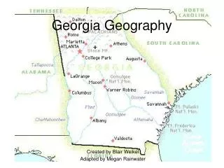
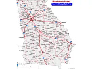
Spatial Geography How do we organize the land? • 159 counties • 5 bordering states • What are they??? (label your map)
Places & Regions People create regions to understand the earth’s complexities • GA has 5 physiographic regions • 18 islands • 58,910 square miles of land • 854 square inland water miles
Physical systems of GA Physical processes that shape the earth’s surface • Coastal islands (SE GA) • Appalachian Mountains (N GA) • Fall Line: line that separates east & west GA
Human systems Where Georgians migrated and settled • Atlanta – capital • Twiggs County – geographic center • Port of Savannah – first major settlement • Brasstown Bald – highest geographic point
Environment & Society Actions of humans that modified the environment • Suburban sprawl (Metro Atlanta) • Interstates & highways • Urban population centers • Rural farmlands & agricultural regions
How do we use Geography? • Interpret GA’s past, understand its present, plan for the future • GA’s location relative to other states affects its growth & development
Absolute Location • A places precise location on the earth’s surface • Latitude • Longitude • GA: 30 – 35 N latitude, 80 – 85 W longitude
Relative Location • Where is GA located compared with other places • North America • Southeastern United States • Atlantic Coast
GA’s Physiographic Regions • How would you describe the Geographic Regions of Georgia?
Fall line Region Precipitation Wetland Barrier Island Continental Shelf Appalachian Plateau Ridge & Valley Blue Ridge Piedmont Plateau Coastal Plain Okefenokee Swamp Key terms & places
Appalachian Plateau Region • GA’s smallest physiographic region • Climate: Cooler because of the mountains • Economy: tourism, forestry • Location: NW corner of GA • Soil: Limestone, shale, & sandstone • Features: Limestone caves, deep canyons, & rock formations Lookout Mountain, Sand Mountain, Chickamauga
Ridge & Valley Region • Climate: warmer than mountains • Economy: Farming (apples & cattle) & carpet industry • Location: between the Blue Ridge Mountains & Appalachian Plateau • Soil: Limestone & clay in valleys, Sandstone & shale on ridges • Features: Dalton (Carpet capital of the world)
Blue Ridge Region • Climate: Mountains provide much of the state’s precipitation (cooler) • Economy: tourism, forestry, vegetable farming, apple farming • Location: Northeastern part of state • Soils: sandy loam & clay • Features: GA’s highest & largest group of mountains, Brasstown Bald (highest point), Helen, GA & Amicalola falls
Piedmont Plateau • Climate: mild winters; hot, humid summers • Economy: industry, tourism, & some farming • Location: from the mountain foothills and goes to central part of state (fall line) • Soil: Red clay & granite base • Features: Chattahoochee, Flint, Oconee, & Ocmulgee rivers Atlanta, Athens, Stone Mountain, Kennesaw MTN
Coastal Plain Region • Climate: mild winters; hot, humid summers • Economy: Farming (peanut, soybean, corn, & pecans) • Location: from Piedmont (fall line) to coast of GA • Soil: Varies from Limestone to clay • Features: Barrier islands, wetlands, Okefenokee Swamp, Savannah, Continental Shelf, Naval Stores & pulp production
Okefenokee Swamp • 681 square miles • Located south of Waycross • Largest swamp in North America • Freshwater wetland • Water lies close to the surface
Barrier Islands • Spanish Explorers called them “islands of gold” • Protect beaches by blocking sand, winds, & water that could erode coastline • 2/3’s remain wilderness areas • Recreation & seafood gathering as well as tourism
Shelves & Lines • Continental Shelf: part of coastal plain that extends into ocean • Fall Line: natural boundary that separates the Coastal Plain from the Piedmont Plateau • Hilly or mountainous lands meet coastal plain • Many water falls here because of the change in land structure • Fall Line water falls provide power source for many GA communities
Georgia’s Climate What do I need to know? • Difference between weather & climate • Effect of weather conditions on state • Different types of weather phenomena
GA’s temperature • Mild climate, subtropical feel on coast • Hot, humid summers & mild winters • Four distinct seasons • Vertical climate: cooler climate at higher elevations (mountains) • July is hottest month, January coldest
GA’s Precipitation • Normal year: 40 – 52 inches of precipitation in central & southern regions, 65 – 76 inches in northern regions • July is wettest month, October is driest • 2007 precipitation – so far
Winds & Currents • Air masses from Gulf of Mexico & Atlantic control warm summer months • Air masses from Canada & Alaska control winter weather • Ocean currents, trade winds, & prevailing westerlies aided travel for early explorers
Storms over GA • GA averages 21 tornados per year resulting in one to three deaths • Most tornados in GA generally occur from March to May
2007 Drought • Attach activity here from other PPT