Download
1 / 18
180 likes | 594 Vues
Geography of Georgia. SS8G1: Describe Georgia with regard to physical features and location Locate Georgia in relation to region, nation, continent, and hemispheres.

E N D
Geography of Georgia SS8G1: Describe Georgia with regard to physical features and location Locate Georgia in relation to region, nation, continent, and hemispheres. Describe the five geographic regions of Georgia: Blue Ridge Mountains, Valley and Ridge, Appalachian Plateau, Piedmont, and Coastal Plain. Locate and evaluate the importance of key physical features on the development of Georgia: Fall Line, Okefenokee Swamp, Appalachian Mountains, Chattahoochee and Savannah Rivers, and barrier islands Evaluate the impact of climate on Georgia’s development
Where in the world is Georgia? • Western and Northern Hemispheres • North America (Continent) • United States (Country) • Southeast (Region) • Georgia (State) • “Empire State of the South” • Paulding (County) • Dallas (Town)
Latitude and Longitude • Latitude: measures distance north and south of Equator; lines stretch east—west. • Longitude: measures distance east and west of the Prime Meridian; lines stretch north—south.
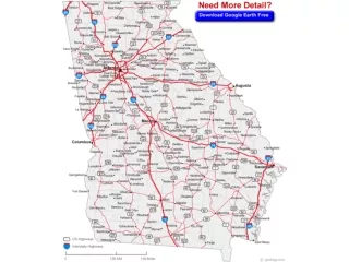
Georgia Facts • Largest state EASTof the Mississippi River • 21stlargest state U.S. • Highest Point: Brasstown Bald • Lowest Point: Coastline • 159 Counties • Largest—Ware • Smallest—Clarke • Center—Twiggs • North: Tennessee and North Carolina • South: Florida and St. Mary’s River • East: Atlantic Ocean, South Carolina, and Savannah River • West: Alabama, Chattahoochee River
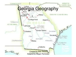
5 Regions of Georgia • Also known as Physiographic Regions • Coastal Plain • Piedmont • Ridge and Valley • Blue Ridge • Appalachian Plateau
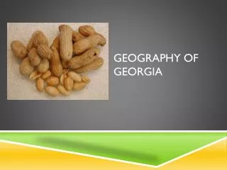
Coastal Plains Northern boundary: Fall Line • Largest region (60% of GA below the Fall Line) • Inner(Northern) • Agricultural- clay, sand and limestone soil • Vidalia Upland FLAT, No hills • Peanuts, peaches, pecans • Outer(Southern) • Coastal • Swamp/Marsh • Okefenokee Swamp • Barrier Islands: • Purpose: protect the beaches • Protect beaches • Continental Shelf: • Protects our coast from hurricanes
Coastal Plains II • Prehistoric ocean extended to the Fall Line • Fossils of shark teeth, whale bones and various ocean life found in Coastal Plains – phosphate, limestone bauxite • 75 miles from coast line inland is known as “The Pine Barrens” • Hardly anything except pine trees grows in this region! • Swamps rivers, streams, estuaries, and islands. • Slow, meandering, widening rivers • Tidal rivers along coastline…saltwater and freshwater share areas during the tides as far as 10 miles inland. • Coastal wetlands… Okeefenokee Swamp
Piedmont“Foot of the Mountains” -Over 50% of the states population • Located between the Coastal Plain and mountains of North GA • Encompasses 30% of state’s area • Gently sloping and rolling hills, streams, rivers lakes • Business and Industry region • Cotton, soybean, wheat, beef and dairy cattle, chicken… • Georgia “Red Clay”, solid rock- granite, marble, mica Atlanta skyline…The Capitol
Blue Ridge • Located in Northeast GA • Highest and largest group of mountains in Georgia , many rivers begin here • Landmarks: • Tallulah Gorge • Beginning of the Appalachian Trail • Brasstown Bald • Mountains act as a barrier to keep in the warm, moist air from the gulf causing precipitation • Lots of rain • sleet, snow, hail • Short growing season- less than 1% farmland- Apples, corn, vegetables, and hardwood timber • Mica, feldspar gold and marble found here!
Ridge and Valley- • Northwest GA-between Blue Ridge and Appalachian Plateau • Low open valleys and narrow, parallel ridges- • ”Wrinkles” • Flat fertile farmlands • Hardwood forest and pastures • Corn soybeans, wheat, cotton • Industrial: textile and carpet manufacturing • DALTON: “Carpet Capital of the World” • Lots of Limestone The textile industry
Discussion: • Explain the importance of the barrier islands. • Why do you think approximately one-half of Georgia’s population lives in the Piedmont region? • Explain why the Blue Ridge region has very little farmland.
Appalachian Plateau- • Smallest region FAR NW Ga (includes only Dade County). • Lookout Mt./ Sand Mt. • Most scenic but least traveled • Called TAG Corner • Tennessee • Alabama • Georgia • Gentle slopes with mountains over valleys • Hardwood forest, pastures for livestock, corn and soybean. • Only known source of coal in Georgia; Iron
Key Physical Features • Fall Line • Stretches across GA from Augusta through Macon to Columbus • Marks the transition from Coastal Plain to the Piedmont • Home of Georgia’s most important mining operations • Kaolin • Appalachian Mountains • Stretch from Canada to Alabama • Highest point in GA: Brasstown Bald Mountain—4784 ft. above sea level • Savannah River • Chattahoochee River
Key Physical Features (cont.) • Okefenokee Swamp • Approx. 7000 years old; peat-filled bog inside a saucer-shaped depression that was once part of the ocean floor • Derives its name from Choctaw Indian words meaning "Land of the Trembling Earth." • Covers 438,000 acres. It is 38 miles in length at its longest point by 25 miles in width at its widest point. The swamp is approximately 700 square miles.
Key Physical Features (cont.) • Savannah River • First European explorers reached the Savannah River in 1540 (though Native Americans had been using the waterway for many years) • Headwaters in SC (only river that flows into GA from outside its borders) • Chattahoochee River • Cherokee: “river of the painted rock” • Supplies water to Atlanta and Columbus • Flows 436 miles; begins as a small stream near Brasstown Bald • Joins the Flint River near the FL state line, becomes the Apalachicola River and empties into the Gulf of Mexico at Apalachicola Bay
What impact does climate have on Georgia’s development? • Weather: day-to-day conditions • Climate: type of weather experienced by a place over a long period of time • Georgia’s climate: mild with subtropical feel near coast • Allows for lower heating/air costs for companies; less weather related absences • Precipitation: • Snow—falls mainly in the mountains, melts and runs off into streams and lakes • Rainfall—aids the growth of crops and forests • Average rainfall—40-52” in central and southern regions; 65-76” in the northern mountains (some in the form of snow) • Drought: 1998-2002—harmed industries, residents • 500 year flood: September 2009
Atlanta Flooding: September 2009 • September 15-23, 2009 • Caused by continuous rain, spawned by moisture from the Gulf of Mexico • Est. damages: $500 million • 10 deaths • 20,000 homes, businesses, and other buildings received major damage; 17 counties named ‘federal disaster areas’ • Many Georgians unprepared—considered 500 year flood
Ticket out the Door • What is the largest region of Georgia? • Where is the highest point in Georgia? • Explain the route of the Chattahoochee River. • What advantages does Georgia offer businesses in regard to climate? • Explain why many Georgians were not prepared for the 500 year flood (Sept. 2009).