Download
1 / 16
160 likes | 354 Vues
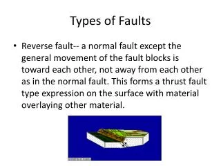
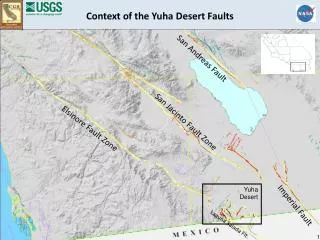
Context of the Yuha Desert Faults. San Andreas Fault. San Jacinto Fault Zone. Elsinore Fault Zone. Yuha Desert. Imperial Fault. Laguna Salada Flt. 1. Previously Mapped Faults in the Yuha Desert. Elsinore. Fault. Known active faults Potentially active faults. Laguna Salada Fault. 2.

E N D
Context of the Yuha Desert Faults San Andreas Fault San Jacinto Fault Zone Elsinore Fault Zone Yuha Desert Imperial Fault Laguna Salada Flt. 1
Previously Mapped Faults in the Yuha Desert Elsinore Fault Known active faults Potentially active faults Laguna Salada Fault 2
Previously Mapped Faults in the Yuha Desert Elsinore Fault Known active faults Potentially active faults Laguna Salada Fault 3
Previously Mapped Faults in the Yuha Desert Elsinore Fault Known active faults Potentially active faults Laguna Salada Fault 4
Previously Mapped Faults in the Yuha Desert Elsinore Fault Known active faults Potentially active faults Laguna Salada Fault 5
New Fault Rupture From El Mayor Earthquake Early Mapping – pre-InSAR • mapping verified fault rupture on known faults • rupture mapped on newly discovered faults Yuha Fault Laguna Salada Fault 6
Interferogram 10/21/2009 – 4/13/2010 field-verified surface faulting (April through May) 8 km 7
Detail of UAVSAR image 10/21/2009 – 4/13/2010 (un-annotated) 8
Detail of UAVSAR image 10/21/2009 – 4/13/2010 early fault mapping (pre-InSAR) 9
Detail of UAVSAR image 10/21/2009 – 4/13/2010 early mapping plus additional faults (post-InSAR) 10
Interferogram 10/21/2009 – 4/13/2010 Interpreted Faults from UAVSAR interpretations from InSAR field-verified surface faulting 8 km 11
Interferogram 4/13/2010 – 7/01/2010 Highlighting Continuing Deformation interpretations from InSAR field-verified surface faulting 8 km 12
Elsinore Fault Ocotillo Fault Zone northwest extension of the Laguna Salada Fault Detail of UAVSAR image 4/13/2010 – 7/01/2010 fault rupture from June 2010 aftershocks 4 kilometers 13
Previously Mapped Faults in the Yuha Desert Elsinore Fault Laguna Salada Fault 14
Faults from All Sources Presenting Risk from Surface Rupture Elsinore Fault interpreted faults field-verified surface faulting northwest extension Ocotillo F.Z. Yuha Fault Laguna Salada Fault Zone 15
Context of the Yuha Desert Faults San Andreas Fault San Jacinto Fault Zone Elsinore Fault Zone Superstition Hills Flt. San Diego Imperial Fault Laguna Salada Flt. 16