Download
1 / 20
200 likes | 219 Vues
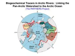
Analyzing the status of altimetric data in the Arctic Ocean (>66ºN) including the evaluation of HY-2A satellite data alongside SARAL/AltiKa and CryoSat-2. The summary covers data availability, geophysical corrections, comparison with existing datasets, and the need for alternative corrections for improved accuracy. Satellite overview, payloads, repeat cycles, and available data sources are discussed. The study emphasizes the importance of investigating biases and the necessity of continuous improvements in sea level time series in the Arctic Ocean.

E N D
HY-2A Satellite Altimetric data Evaluation in the Arctic Ocean Yongcun Cheng Ole Baltazar Andersen
Outline • Introduction • Status of altimetric data in the Arctic Ocean (>66ºN) • HY-2A (Data from NSOAS, IGDR) • SARAL/AltiKa • CryoSat-2 2. HY-2A altimetric data in the Arctic Ocean • Applied range and geophysical corrections • Comparision with RADS Altika and CryoSat-2 data • DUACS NRT HY-2A data • 20+ years of sea level timeries in the Arctic Ocean 3. Summary
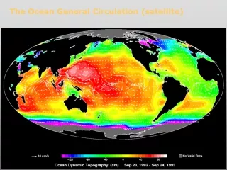
Data Status Feb. Mar. 1 Jul. 0 Data availability in along-track RADS (ERS-1/2-Envisat), reprocessed (ERS-1/2-Envisat) and DUACS gridded weekly sea level products. Envisat was dead in April 2012. HY-2, CryoSat-2 and Altika available in the Arctic Ocean.
HY-2Aoverview • HY-2A (‘HaiYang’ denotes Ocean) from the National Satellite Ocean Application Service has been designed for the monitoring the Ocean dynamics. • HY-2A was launched in August 2011. • HY-2A payloads: Radar altimeter (Ku and C bands), orbit altitude of 965 km, sun-synchronous with 99º inclination. • Repeat cycle: 14 days (for three years) and 168 days. • Data available from NSOAS.
SARAL/AltiKa overview • Operator: ISRO/CNES, enable better observation of ice, rain, coastal zones, land masses (forests, etc.), and wave heights. • SARAL was launched in Feb, 2013. • SARAL payloads: Radar altimeter (Ka band), orbit altitude of 800 km, sun-synchronous with 98.55º inclination. • Repeat cycle: 35 days (the same ground-track as Envisat) • Data available from RADS.
CryoSat-2 overview The SAR mode (green) operated over ice-covered regions and the coastal zone. The SAR Interferometric (SARIn) and Low Resolution Mode (LRM) modes are in purple and red, respectively (https://earth.esa.int). Data available from RADS.
Range and Geophysical corrections Andersen and Scharroo, 2011
RADS (AltiKa and CryoSat-2): Range and Geophysical corrections Dry tropospheric correction:ECMWF model Wet tropospheric correction:radiometer measurements (AltiKa)/ECMWF model (CryoSat-2) Ionosphere correction:NIC09 Sea State Correction: hybrid model Ocean tide:GOT4.8Inverted Barometer:MOG2D MSS: DTU10
Summer CryoSat-2 AltiKa Sea level anomaly (in meters) maps for the same period between 20130803 and 20130817 (HY-2A cycle049) |SLA|<1m HY-2A
HY-2A Globally data HY-2A+10cm AltiKa CryoSat-2 Jason-2 Sea level anomaly (in m): Time period 20130808 to 20130817. CryoSat-2 Jason-2
All corrections (50ºS-50ºN) Time period: 201305 (independent process by Yalong Liu)
Winter AltiKa CryoSat-2 Sea level anomaly (in meters) maps for the same period between 20140104 and 20140118 (HY-2A cycle060) HY-2A
HY-2/Jason-2 crossover dif. Crossover sea surface height differences between Jason-2 and HY-2 satellite altimetric data in December 2013 Time period: 201312 (independent process by Yalong Liu)
(Available from 20140514) DUACS NRT HY-2A data AltiKa (RADS) CryoSat-2 (RADS) SLA map for the time period 20140514-20140601 HY-2A (DUACS)
DTU reprocessed ERS-1/2-Envisat (black)RADS CryoSat-2 (blue)RADS AltiKa (red) Sea level timeseries in the Arctic Ocean
Sea level timeseries in the Arctic Ocean (HY-2A) m SLA cycle averaged Number of data
Summary • HY-2A satellite altimetry provides valuable data in the Arctic Ocean. • More alternative range and geophysical corrections are required in the released HY-2A data sets for comparison. • The bias among the satellite altimetry missions needs further investigation to improve the long term sea level time series in the Arctic Ocean. • SLA ‘drops’ in 2013 needs further investigation.