Hurricanes
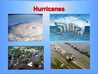
Hurricanes. Tropical Cyclones. These are the greatest storms on Earth and are among the most destructive of natural disasters. They are know by several names, depending on where they form. Hurricane

Hurricanes
E N D
Presentation Transcript
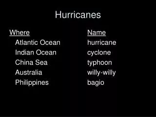
Tropical Cyclones • These are the greatest storms on Earth and are among the most destructive of natural disasters. • They are know by several names, depending on where they form. • Hurricane • Used in the Atlantic and eastern and central Pacific and is derived from the Carib Indian word “huracan” for the Carib god of evil. • Typhoon • Used in the western Pacific • Cyclone • Indian Ocean term • Willy Willy • Used in Australia (also “tropical cyclone”)
Naming Hurricanes • Starting in 1953 • NWS started using female names • Prior to 1953 • Only the most severe hurricanes were given names • They were often named • For the place they did the most damage . . . • Galveston Hurricane of 1900 • Or the time they hit . . . • Labor Day Hurricane of 1935 • Hurricane of 1938 (Also called “The Long Island Express” or the New England Hurricane of 1938 • Starting in 1979 • Male and female names were included in lists for the Atlantic and Gulf of Mexico
Tropical Storm and Hurricane Names for the Atlantic, Gulf of Mexico, and Caribbean Sea Letters Q, U, X, Y, and Z are not used because there are few common names starting with these letters
Six Separate Lists • The names are used over again at the end of each six-year cycle. • Each calendar year starts with the next list, even if all the names weren't used the previous year. • One list is repeated every seventh year. • For example, in 2012 the 2006 list will be used again. • The exception will be if any names have been retired. The names of storms which have been extremely deadly and costly aren't used again.
More on Naming Hurricanes • If more than 21 named tropical cyclones occur in the Atlantic basin in a season • Additional names are taken from the Greek alphabet (Alpha, Beta, Gamma, Delta, Epsilon, Zeta, etc.) • If a storm forms in the off-season • The name used is based on the calendar year • Retiring Names • Whenever a hurricane has had a major impact, any country affected by the storm can request that the name of the hurricane be “retired” by agreement of the World Meteorological Organization (WMO) • This means it can’t be used for at least 10 years
Tropical Cyclone Characteristics • Form over tropical oceans between 5o and 20o latitude (except the South Atlantic and eastern south Pacific) • By international agreement, a storm is classified a hurricane if wind speeds are 74 mph (119 km/hour) and has a rotary circulation.
Hurricane Fran Visible Image 9/5/96 FL Cuba • Mature hurricanes average about 600 km (372 miles) across but can be up to about 1500 km (930 miles). • Pressure drops as much as 60 millibars from the outer edge to the center. • Steep pressure gradient generates rapidly spiraling winds which increase as the center of the storm is approached (due to conservation of angular momentum). • Duration: A week or more
The Structure of a Hurricane:Convective Rain Bands Tropical moisture spiraling inward creates rain bands that pinwheel around the storm center
The Structure of a Hurricane: The Eye Wall Eye Wall • As the inward rush of warm, moist surface air reaches • the center of the storm it rises in a ring of cumulonimbus towers. • It’s a doughnut shaped wall of intense convective activity.
The Eye Wall Produces the most intense rainfall and greatest wind speeds Katrina Eye Wall - 2005 Hurricane Charley - 2002
The Structure of a Hurricane:Outflow Outflow prevents the convergent flow at lower levels from “filling in” the storm.
The Structure of a Hurricane:The Eye Average Diameter is 20 to 30 miles (32 to 48 km) • A quasi-circular or quasi-oval region of light winds and skies that are clear to partly cloudy • and free of rain. • Caused by descending air that heats by compression, making it the warmest region of the storm.
Can you identify when the eye passed? Eye Wind speeds recorded by a data buoy in the eastern Gulf of Mexico during the passage of Hurricane Kate (1985)
Hurricane WilmaOctober 2005 Eye The record for the lowest surface air pressure for an Atlantic Hurricane, 882.0 mb, was recorded in the eye on Oct. 18
Vertical Section and Associated Patterns of Wind, Pressure, and Rain
Hurricane Formation and Decay Cooperative Program for Operational Meteorology, Education and Training
Hurricanes are Huge Heat Engines • Fueled by latent heat released when huge quantities of heat are released by condensation. • Released heat warms the air making it buoyant (unstable). • Results in lower surface air pressure • Initiates a rapid inflow of air • Requires a large quantity of heat to get started. • Develop most often in late summer • Ocean temperatures 27o C (80o F)
Hurricanes Form in the Tropics • Often form in the ITCZ. • Few form poleward of 20 degrees latitude • Water isn’t warm enough • Not within 5 degrees of the equator • Coriolis force is too weak to initiate rotary motion
Tropical Disturbances Africa S. America • Originate in Africa as disorganized arrays of clouds and thunderstorms • Weak pressure gradient and little or no rotation • Most die out but some will develop rotation
Disturbances Can Become Easterly Waves • Streamlines (arrows) show low-level airflow. • East of the axis • Winds turn slightly poleward and converge forming clouds • Tropical Disturbances are associated with this side of the wave • West of the axis • Winds diverge • Clear skies • Can develop into a tropical depression
Trade Wind InversionsPrevent Development into a Tropical Depression • Subsiding air in a nearby subtropical high • Turbulence near the surface prevents lower level air from sinking • An inversion develops between the lower zone and the subsiding warmer layers above • This reduces the ability of the air to rise.
When Conditions Favor Hurricane Development . . . • No inversion exists and upper-level winds are not too strong • A Tropical Depression Forms • Pressure drops at center with a steep gradient • Surface winds strengthen and bring in additional moisture • Condensation releases heat and air rises • Further adiabatic cooling forms more clouds • Condensation releases more latent heat • Higher pressure develops aloft resulting in outflow • These processes continue and the storm forms.
Hurricane Decay (2) (3) (1) Hurricane Allen (1980) loses strength as it moves over land. • Hurricanes diminish in intensity whenever • They are deprived of the warm moisture needed for the source of latent heat by • Moving over land (roughness of surface also rapidly reduces wind speeds) • Moving over cooler ocean water • Large-scale flow aloft is unfavorable
Storm Tracks For 2005 - 28 Named Storms! • Influenced by • Trade Winds • Prevailing Southwesterlies • Jet Stream • Other Highs and Lows
Hurricane Destruction • Depends on • Strength of the Storm • Size and population density of the area affected • Nearshore bottom configuration
Wind Damage Hurricane Andrew Hurricane Wilma • The most obvious type of damage • Debris becomes flying missiles • Mobile homes are particularly vulnerable • High rise buildings, especially upper floors, • areVulnerable • Tornadoes that are produced by some • hurricanes contribute to the storms damage Damage to the roof of the Superdome from Hurricane Katrina
Hurricane Winds Storm surge will be greatest along the coastline hit by the right side of the hurricane
Storm Surge • The dome of water 65 to 80 km wide that sweeps across the coast near the landfall position of the eye • The most devastating damage in the coastal zone • Responsible for 90% of hurricane-caused deaths • Cause: • Strong onshore winds push water towards the shore • Winds also create violent wave activity. • Low pressure on ocean surface is relatively insignificant
Storm Surge of the Galveston Hurricane of 1900 An unexpected Category 4 storm
25-Storm Surge From Hurricane Camille (1969) Before The Richelieu Apartments in Pass Chistian, MS After
Saffir-Simpson Scale • Based on study of past storms • Ranks the relative intensities of hurricanes • Established based on observed conditions. • Scale of 1 to 5 • Category 1 is least severe • Category 5 is most severe • Rare • Not likely in the northeast because water temperatures are too cool.
Category One • Wind speed: • 74-95 mph (119-153 km/h) • Storm surge: • 4-5 feet above normal • Central Pressure: 980 mb • Damage: • Damage primarily to unanchored mobile homes, shrubbery, and trees along with some coastal road flooding and minor pier damage • Examples: • Allison, 1995; Danny, 1997
Category Two • Wind speed: • 96-110 mph (154-177 km/h) • Central Pressure: • 965-979 mb • Storm surge: • 6-8 feet above normal • Damage: • Roofing, door and window damage to buildings; Considerable damage to shrubbery and trees, mobile homes, poorly constructed signs, and piers • Examples: • Bonnie, Georges, 1998
Category Three • Wind speed: • 111-130 mph (178-209 km/h) • Central Pressure: • 945-964 mb • Storm surge: • 9-12 feet above normal • Damage: • Structural damage to small residences and utility buildings; foliage blown off trees and large trees blown down; mobile homes destroyed • Examples: • Roxanne, 1995; Fran, 1996; Rita, 2005.
Category Four • Wind speed: 131-155 mph (210-249 km/h) • Central Pressure: • 920-944 mb • Storm surge: • 13-18 feet above normal • Damage: • Extensive damage to doors, windows and lower floors of shoreline houses; total roof failures on small residences; shrubs, trees, and all signs blown down; mobile homes completely destroyed • Examples: • Hugo, 1989, Luis, Felix, Opal, 1995, Emily, Katrina, Wilma 2005.
Hurricane Katrina A Category 5 over the Gulf of Mexico August 18, 2005 Came ashore as a category 4 storm and 8 hrs later was still a Category 1
Category Five • Wind speed: • Greater than 155 mph (249 km/h) • Central Pressure: • <920 mb • Storm surge: • generally greater than 18 feet above normal • Damage: • Complete roof failure on many buildings and some complete building failures with small utility buildings blown over or away; severe and extensive window and door damage; mobile homes completely destroyed • Examples: • Camille, 1969; Gilbert, 1988; Andrew, 1992; Mitch, 1998
Atlantic Hurricanes that made Landfall as Category 5 Storms 1 1 Since records began in 1886