Hurricanes
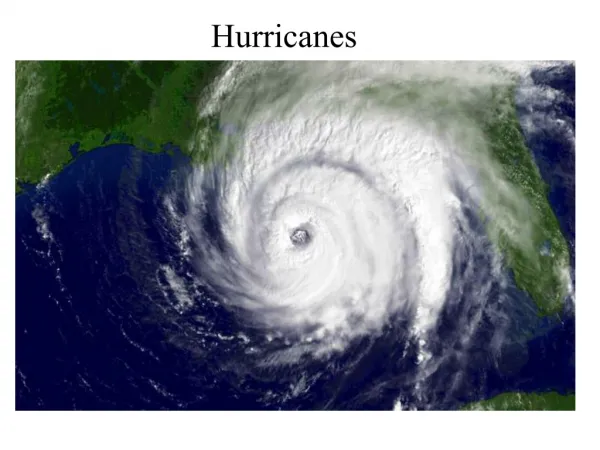
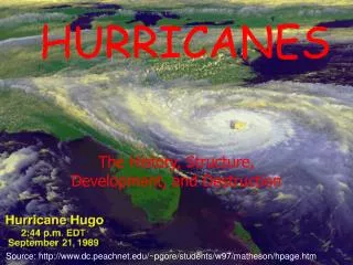
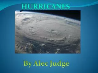
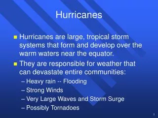
Hurricanes Hurricanes are large, tropical storm systems that form and develop over the warm waters near the equator. They are responsible for weather that can devastate entire communities: Heavy rain -- Flooding Strong Winds Very Large Waves and Storm Surge Possibly Tornadoes Hurricanes

Hurricanes
E N D
Presentation Transcript
Hurricanes • Hurricanes are large, tropical storm systems that form and develop over the warm waters near the equator. • They are responsible for weather that can devastate entire communities: • Heavy rain -- Flooding • Strong Winds • Very Large Waves and Storm Surge • Possibly Tornadoes
Hurricanes • To begin our study of hurricanes we must first look at the typical weather in the tropics. • The sun typically remains high in the sky all year -- little variation in temperature with seasons. • The strong sun heats the water and enhances the evaporation of the water. • The general flow of air near the equator is out of the east -- Trade Winds.
Hurricanes • The trade winds blow from the northeast in the Northern Hemisphere and from the southeast in the Southern Hemisphere. • A region of convergence (Intertropical Convergence Zone -- ITCZ) creates a band of thunderstorms near the equator.
Hurricanes • Since pressure gradients are small near the equator, we look at the flow of wind to find trough regions. • A trough or ripple in the easterly flow is known as a “tropical wave.” • Surface convergence occurs on the east side of this wave and surface divergence occurs on the west side. • Thunderstorms tend to form on the east side of the tropical wave.
Conditions for Tropical Wave Development • The wave must be north or south of the equator. • Coriolis force is zero at the equator. • Conditional Instability • Weak vertical shear • This is different from what we want in the mid-latitudes. • Warm sea-surface temperatures (SST) • Typically SSTs are greater than 26oC
Hurricane Development • Convergence at the surface leads to convergence of moisture. • The convection or thunderstorms that form release latent heat which intensifies the surface low. • The warm core column of air will create an upper level high pressure center. • The weak shear allows the storm to remain vertical and allows for the latent heat release to enhance the surface low.
Hurricane Development H The energy for the growth of the storm comes from the ocean (evaporation). Low shear will keep the heating in the core to remain above the surface convergence. Strong shear would rip the storm apart. Heating L
Hurricane Development H L Strong Heating As the winds increase, the ocean surface becomes “rougher” and friction is added to the balance of forces. This friction enhances surface convergence. Strong Convergence L
Hurricane Structure This feedback mechanism continues as long as the favorable conditions for hurricane growth continue to exist.
Hurricane Development • This feedback mechanism is called CISK: • Conditional Instability of the Second Kind • The Eye is the central region of the hurricane. • It is often cloud free and has relatively calm winds. • The eye is associated with subsidence that, in the strongest storms, keeps the eye cloud-free.
Birthplaces of Hurricanes Hurricane birthplaces are near the equator but between 5-15 degrees latitude away from the equator. The paths tend to be easterly as the hurricanes develop and grow.
Tropical Wave Development • Tropical Disturbance • A collection of thunderstorms with a slight circulation. • Tropical Depression • Closed circulation • Wind speeds between 20-34 knots. • Tropical Storm • Closed circulation • Wind speeds between 35-64 knots. • The storm is named.
Tropical Wave Development • Tropical Disturbance • A collection of thunderstorms with a slight circulation. • Tropical Depression • Closed circulation • Wind speeds between 20-34 knots. • Tropical Storm • Closed circulation • Wind speeds between 35-64 knots. • The storm is named.
Tropical Wave Development • Hurricane • Closed circulation • Sustained wind speeds in excess of 64 kts (~74 mph). • Saffir-Simpson Scale • A numerical scale (1-5) that describes the damage potential of a hurricane. • A quick and easy description of the strength of a hurricane.
Hurricane Hazards • Strong Winds • Hurricane sustained wind speeds are in excess of 74 mph. • Occasionally can get as high as 155 kts. • Winds are typically stronger in Pacific storms -- storms have more time grow in the larger Pacific ocean. • Wind damage can be significant especially to weakly built houses. • Spin-up vortices can cause very strong and damaging wind gusts.
Hurricane Winds • Hurricane winds are typically the strongest on the right side of the storm. • The forward motion of the storm is added to the wind speeds on the right side of the storm to enhance the surface winds. Strongest winds on the right side of the storm. Weaker winds
Hurricane Hazards • Inland Flooding • Torrential rains can, especially if the hurricane moves slowly inland, can cause substantial flooding. • Camille (1969) • Inland in Mississippi • Flooding in Virginia • Agnes (1972) • Inland in Florida • $6.3 Billion in damage along the East Coast • Flooding in Pennsylvania • Alberto (1994) • Never a hurricane! (Tropical Storm) • Stalled over Georgia -- Americus, GA received 21”
Flooding in Richmond, VA Hurricane Camille -- 19 August 1969
Flooding in Wilkes-Barre, PA Hurricane Agnes -- 19-20 June 1972
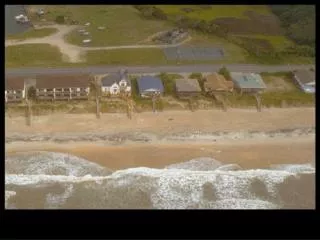
Storm Surge • The abnormal rise in the ocean level associated with the hurricane landfall. • As the hurricane approaches the coast, it “pushes” a large mass of water in front of it. • When this pile of water reaches the coast, the water levels can rise as much as 7 meters (~22 feet).
Storm Surge • Usually 80 - 160 km wide. • Not a “tidal wave” or tsunami. • The dramatic rise in the sea level can cause catastrophic damage. • The greatest storm surge is associated with: • Stronger hurricanes • High tide • Shape of the shore
Before the Hurricane Richelieu Apartments -- Pass Christian, MS Hurricane Camille -- 17 Aug 1969
Camille Storm Surge Pass Christian, MS Storm Surge = 7.4 m Hurricane Camille -- 17 Aug 1969
Before Hugo Folly Beach, SC -- 22 September 1989
After Hugo Folly Beach, SC -- 22 September 1989
Death of a Hurricane • Moves out of the warm, moist tropical air. • Moves over land. • Loss of moisture source • Increased surface friction • Temperature of the land is cooler than the warm ocean • Moved under unfavorable large scale flow. • High shear can rip a storm apart • Large scale subsidence can inhibit convection
Hurricane Warnings • Hurricane warnings are designed to protect human life and their property. • Possible Evacuations • Detection techniques • Satellites • Radar • Aircraft Reconnaissance • Data Buoys • Weather Channel Reporters!
Satellite Detection of Camille NIMBUS III Satellite -- 21 August 1969
Satellite Tracking of Allen Hurricane Allen -- August 1980
Satellite Tracking of Allen Hurricane Allen -- August 1980
Satellite Tracking of Allen Hurricane Allen -- August 1980
Radar Detection of Hurricanes Hurricane Andrew -- August 24, 1992
Aircraft Detection of Hurricanes Dropsondes WP-3 Aircraft
Tropical Storm Warnings • Tropical Storm Watch • Possible tropical storm conditions expected in the next 36 hours. • Prepare to take appropriate action. • Tropical Storm Warning • Tropical storm conditions are expected in the next 24 hours. • Take action!
Hurricane Warnings • Hurricane Watch • Possible hurricane conditions expected in the next 36 hours. • Prepare to take appropriate action. • Hurricane Warning • Hurricane conditions are expected in the next 24 hours. • Get out of Dodge!
Building for Disaster? • 45 million people now live along hurricane-prone regions in the U.S. • Gulf Coast population: • 1960 -- 5.2 Million • 1990 -- 10.1 Million • Doubled in only 30 years. • Florida to Virginia • 1960 -- 4.4 Million • 1990 -- 9.2 Million
Can We Evacuate? • Hurricane evacuation times currently range from 15 - 30 hours depending on the locale. • Current warnings are only valid for 24 hours. • Can the transportation infrastructure handle such a mass exodus quickly enough?
Building for Disaster? • We are constructing more and larger dwellings along our hurricane-prone coastlines.
Building for Disaster? Miami, FL
Better Construction • Improved construction techniques may help alleviate some storm damage. • Reinforcing seawalls • Creating larger sand dunes and beaches • Building housing on “stilts” • Better tie-downs between the foundation and the walls and between the walls and the roof. • Not much will stop a 7 m storm surge.