C.J. Cox Instructor
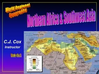
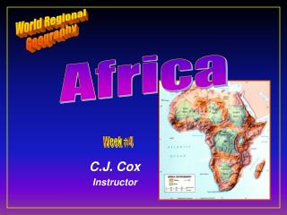
World Regional Geography. Africa. Week #4. C.J. Cox Instructor. Africa South of the Sahara. Ten Geographic Qualities of Africa Physical Geography of Africa Cultural Geography of Africa Historical Geography of Africa African Sub-regions. Ten Geographic Qualities of Africa.

C.J. Cox Instructor
E N D
Presentation Transcript
World Regional Geography Africa Week #4 C.J. Cox Instructor
Africa South of the Sahara • Ten Geographic Qualities of Africa • Physical Geography of Africa • Cultural Geography of Africa • Historical Geography of Africa • African Sub-regions
Ten Geographic Qualities of Africa • 1. Continent dominated by it’s plateau character • 2. Majority of people depend on farming for their livelihood
Ten Geographic Qualities of Africa • 3. High amount of disease (malaria, sleeping sickness, aids) • 4. African boundaries drawn by Europeans at the beginning of the colonial period • 5. Economic development in scattered areas
Ten Geographic Qualities of Africa • 6. Rich in raw materials vital to industrialized economies • 7. Inter-regional connections are poor • 8. Africa has been a place of competition and conflict between major powers
Ten Geographic Qualities of Africa • 9. Highest population growth despite diseases & food shortages • 10. Contrasting areas from civil wars to stability Mozambique Coast
Relative Location of Africa • Lying astride the equator • Between the Atlantic/Indian and Mediterranean • On the periphery of the land hemisphere • Second largest continent • 4500 miles from east to west • 4800 miles from north to south Peripheral core Peripheral Peripheral Peripheral
Africa South of the Sahara • Ten Geographic Qualities of Africa • Physical Geography of Africa • Cultural Geography of Africa • Historical Geography of Africa • African Sub-regions
Physical Geography of Africa • LANGUAGES • diversity of African languages, human racial groups • Islam in the north • Niger Congo languages in south • dozens of languages in a single country • 1/7 of the inhabited world with 1/3 of the languages • Khoisan (Bushman language) • Malay-Polynesian & Germanic in the south • POPULATION • 475 million • concentrations in Nigeria, Lake Victoria & Southern Africa • Diseased areas (1 million children die from Malaria a year) • Sahel (suh-hell) Ethiopia, West Africa • poor soils, inadequate precipitation • AGRICULTURE • subsistence farming, herding • military governments • corn not as high a yielding grain as wheat or rice • population growth higher than in India & China • increase of 105 million from 1980 to 1988 • per capita food production decreasing • HISTORY • Pre Euopean Prelude absence of written history • Trade places like Timbuktu • East Africa trade with China, India Indonesia & Arabs • Colonial Transformation • 1600s series of coastal stations & forts • trade with African middlemen for slaves, gold, ivory & spices • Arabs had slave trade long before Europeans • 30 million slaves deported from Africa all over world • European presence brought a reorientation of trade • interior states decline • 400 years later European carved up Africa • Penetration into the interior not until mid of 1800's • Belgium Congo • Portuguese Angola & Mozambique • French western Africa (France still maintains influence) • Interest in colonies' labor transit agriculture • (cotton Mozambique, coffee Angola) minerals • WEST AFRICA (bulge Lake Chad to Senegal to coast to Sahara) • large desert states to the north • smaller coastal states • most populated region • cultured area • coastal location favorable for trade • Nigeria • Moslem north • mid area poor unproductive & disease • oil reserves in the Niger delta • urbanization 29% • capital Abuja in center • Burkina Faso • East Africa • highland plateau Africa savanna • Lake Victoria 3 major countries come together • Tanzania largest country with 24 million • country with out a prime core area • African socialism • cooperatives & new villages • cotton north/ tea south • Kenya 22.8 million • good agricultural areas • strong core area • capitalist state • Nairobi/Mombassa • tourism • pop. increase 4.2 % annually • doubling time is 17 years • by 2025 4 times as many as today (83 million) • over 1/2 pop under 15 • average 8 kids per woman • Uganda 16.2 million • military regime of Amin 1971-1979 • 75,000 Asians evacuated & commercial system fell apart • death by violence 300,000 • economy still in shambles & fragmented • Obote • Burundi & Rwanda 12 million • EQUATORIAL AFRICA • Zaire, Congo, Cameroon, Central African Republic • Gabon Equatorial Guinea • Zaire 33 million & 900,000 sq. miles • wealth within the basin rim • river system nuetralized by rapids • independence in 1960 • Others 17 millions • Gabon modest oil reserves, forests & lots of minerals • Cameroon self sufficient in food, oil reserves • SOUTHERN AFRICA • South Africa • the dominant political & economic force • & military • the continent's richest in minerals • gold, chromium, diamonds, platinum, • coal and iron ore. • political influence in Southern Africa • operates ports in Mozambique • assistance programs in Malawi • med. agriculture • wool • plateau country • southern tip • 471,000 square miles • 34.7 million • great ethnic diversity English, Boers, (5 mill) • colored (3 mill) • Asians, 1 mill Indians & blacks (25 million) • Dutch founded Cape Town in 1652 • 1800 the British • Boer War 1899-1902 Afrikaners • labor for sugar plantations & mines • Johannesburg 2.2 mill (gold field) • Pretoria 1 mill • plateau area • apartheid ( apart - hate) separateness • Afrikaners policy in 1948 • minimize contact of ethnic groups • homelands • immigrant workers • government- today must concentrate on keeping control • Zambia landlocked • copper in south • Zimbabwe chrome/asbestos • steppe • 9.6 million • considerable economic potential • Independence in 1980 • Malawi's core in south • Mozambique exit for Malawi, Zimbabwe and South Africa • cashews & coconut • 14.7% Urbanized • Independence in 1975 • Angola conflict with South Africa in Namibia while • fighting an insurgent state in the south • central part of it's own territory. • oil • coffee • independence in 1975 • Namibia • copper, lead & zinc steppe • Lesotho • mountainous enclave surrounded by South Africa • poor & landlocked • NORTH AFRICA / SW ASIA • LOCATION & SIZE • HISTORY • POPULATION • MINERAL RESOURCES • PHYSICAL GEOGRAPHY • POLITICAL GEOGRAPHY • ECONOMY • URBANIZATION • SUB-SAHARAN AFRICA • TEN GEOGRAPHIC QUALITIES OF AFRICA • 1) • 2) • 3) • 4) • 5) • 6) • 7) • 8) • 9) • 10) • PHYSICAL GEOGRAPHY • Plate Tectonics • Deserts • Mountains • Rivers • Lakes • CLIMATE • LANGUAGES • POPULATION • AGRICULTURE • HISTORY • WEST AFRICA • Nigeria • Burkina Faso • East Africa • Tanzania • Kenya • Uganda • Burundi & Rwanda • EQUATORIAL AFRICA • Zaire • Gabon • Cameroon • SOUTHERN AFRICA • South Africa Malawi • MozambiqueAngola • NamibiaLesotho • ZambiaZimbabwe • SUB-SAHARAN AFRICA • TEN GEOGRAPHIC QUALITIES OF AFRICA • 1) Continent dominated by the continent's plateau character • 2) majority of people depend on farming for their livelihood • 3) high amount of disease (malaria, sleeping sickness) • 4) African boundaries drawn at the beginning of the colonial period • 5) Economic development in scattered areas • 6) Rich in raw materials vital to industrialized economies • 7) Inter-regional connections are poor • 8) Africa a place of competition and conflict between major powers • 9) Highest population growth despite diseases & food shortages. • 10) contrasting areas, some of civil wars others with stability • Environmental deterioration, • diseases, • population growth is highest in world, • political conflicts • PHYSICAL GEOGRAPHY • Lying astride the equator • Atlantic/Indian/Mediterranean • 2nd in size to Eurasia • Plate Tectonics • core for the super continent Gondwana • deep gorges & rift valleys resultant from continental movement north • Deserts • Mountains • Rivers • Lakes • CLIMATE • Symmetrical about the equator • Rainy climate of equator • Savanna lands of trees with grass • Steppe lands of only grass • Arid conditions of Sahara & Kalahari Deserts • Med. zones at extremities • LANGUAGES • diversity of African languages, human racial groups • Islam in the north • Niger Congo languages in south • Malay-Polynesian & Germanic in the south • POPULATION • 475 million • concentrations in Nigeria, Lake Victoria & Southern Africa • AGRICULTURE • subsistence farming, herding • military governments • HISTORY • Pre Euopean Prelude absence of written history • Colonial Transformation • 1600s series of coastal stations & forts • trade with African middlemen for slaves, gold, ivory & spices • Arabs had slave trade long before Europeans • 30 million slaves deported from Africa all over world • European presence brought a reorientation of trade • interior states decline • 400 years later European carved up Africa • Penetration into the interior not until mid of 1800's • Belgium -Congo • Portuguese - Angola & Mozambique • French - western Africa (France still maintains influence) • Interest in colonies' labor transit agriculture • (cotton Mozambique, coffee Angola) minerals • WEST AFRICA • Nigeria • Burkina Faso • East Africa • Tanzania • Kenya • Uganda • Burundi & Rwanda • EQUATORIAL AFRICA • Zaire • Gabon • Cameroon • SOUTHERN AFRICA • South Africa Malawi's • MozambiqueAngola • NamibiaLesotho • ZambiaZimbabwe • World Regional Geography • Sierra College • C. J. Cox • SUBSAHARAN AFRICA • PHYSICAL FEATURES • Landforms Bodies of Water • Kalahari Desert Namib Desert Mt. Kilimanjaro The Rift Valley Drakensberg Mts. Great Escarpment Lake Tanganyika Lake Victoria Congo (Zaire) River Niger River The Cape of Good Hope Zambezi River Orange River Lake Malawi • COUNTRIES • West AfricaEquatorial East AfricaSouthern • Nigeria Benin Ghana Burkina Faso Ivory Coast Liberia Sierra Leone Guinea Guinea Bissau Gambia Senegal Togo Cameroon Cent. African Rep. Democratic Republic of the Congo(Zaire) Congo Gabon Equatorial Guinea Cabinda Rwanda Uganda Burundi Kenya Tanzania Angola Zambia Malawi Mozambique Zimbabwe Botswana Swaziland Lesotho South Africa Namibia Madagascar • NORTH AFRICA • PHYSICAL FEATURES • Landforms Bodies of Water • Sahara Desert Atlas Mountains Nubian Desert Ahaggar Mts. Ethiopian HighlandsNile Red Sea Persian Gulf • COUNTRIES • North African Countries Morocco Algeria Tunisia Libya Egypt Sudan Mauritania Mali Niger Chad Western Sahara The Horn Eritrea Ethiopia Djibouti Somalia • Plate Tectonics • Plateaus • Deserts • Mountains • Rivers • Lakes • Climates
Physical Geography of Africa • Plate Tectonics • core for the super continent Gondwana • deep gorges & trenches resultant from continental movement • rift valleys or hugh parallel cracks or faults
Physical Geography of Africa • LANGUAGES • diversity of African languages, human racial groups • Islam in the north • Niger Congo languages in south • dozens of languages in a single country • 1/7 of the inhabited world with 1/3 of the languages • Khoisan (Bushman language) • Malay-Polynesian & Germanic in the south • POPULATION • 475 million • concentrations in Nigeria, Lake Victoria & Southern Africa • Diseased areas (1 million children die from Malaria a year) • Sahel (suh-hell) Ethiopia, West Africa • poor soils, inadequate precipitation • AGRICULTURE • subsistence farming, herding • military governments • corn not as high a yielding grain as wheat or rice • population growth higher than in India & China • increase of 105 million from 1980 to 1988 • per capita food production decreasing • HISTORY • Pre Euopean Prelude absence of written history • Trade places like Timbuktu • East Africa trade with China, India Indonesia & Arabs • Colonial Transformation • 1600s series of coastal stations & forts • trade with African middlemen for slaves, gold, ivory & spices • Arabs had slave trade long before Europeans • 30 million slaves deported from Africa all over world • European presence brought a reorientation of trade • interior states decline • 400 years later European carved up Africa • Penetration into the interior not until mid of 1800's • Belgium Congo • Portuguese Angola & Mozambique • French western Africa (France still maintains influence) • Interest in colonies' labor transit agriculture • (cotton Mozambique, coffee Angola) minerals • WEST AFRICA (bulge Lake Chad to Senegal to coast to Sahara) • large desert states to the north • smaller coastal states • most populated region • cultured area • coastal location favorable for trade • Nigeria • Moslem north • mid area poor unproductive & disease • oil reserves in the Niger delta • urbanization 29% • capital Abuja in center • Burkina Faso • East Africa • highland plateau Africa savanna • Lake Victoria 3 major countries come together • Tanzania largest country with 24 million • country with out a prime core area • African socialism • cooperatives & new villages • cotton north/ tea south • Kenya 22.8 million • good agricultural areas • strong core area • capitalist state • Nairobi/Mombassa • tourism • pop. increase 4.2 % annually • doubling time is 17 years • by 2025 4 times as many as today (83 million) • over 1/2 pop under 15 • average 8 kids per woman • Uganda 16.2 million • military regime of Amin 1971-1979 • 75,000 Asians evacuated & commercial system fell apart • death by violence 300,000 • economy still in shambles & fragmented • Obote • Burundi & Rwanda 12 million • EQUATORIAL AFRICA • Zaire, Congo, Cameroon, Central African Republic • Gabon Equatorial Guinea • Zaire 33 million & 900,000 sq. miles • wealth within the basin rim • river system nuetralized by rapids • independence in 1960 • Others 17 millions • Gabon modest oil reserves, forests & lots of minerals • Cameroon self sufficient in food, oil reserves • SOUTHERN AFRICA • South Africa • the dominant political & economic force • & military • the continent's richest in minerals • gold, chromium, diamonds, platinum, • coal and iron ore. • political influence in Southern Africa • operates ports in Mozambique • assistance programs in Malawi • med. agriculture • wool • plateau country • southern tip • 471,000 square miles • 34.7 million • great ethnic diversity English, Boers, (5 mill) • colored (3 mill) • Asians, 1 mill Indians & blacks (25 million) • Dutch founded Cape Town in 1652 • 1800 the British • Boer War 1899-1902 Afrikaners • labor for sugar plantations & mines • Johannesburg 2.2 mill (gold field) • Pretoria 1 mill • plateau area • apartheid ( apart - hate) separateness • Afrikaners policy in 1948 • minimize contact of ethnic groups • homelands • immigrant workers • government- today must concentrate on keeping control • Zambia landlocked • copper in south • Zimbabwe chrome/asbestos • steppe • 9.6 million • considerable economic potential • Independence in 1980 • Malawi's core in south • Mozambique exit for Malawi, Zimbabwe and South Africa • cashews & coconut • 14.7% Urbanized • Independence in 1975 • Angola conflict with South Africa in Namibia while • fighting an insurgent state in the south • central part of it's own territory. • oil • coffee • independence in 1975 • Namibia • copper, lead & zinc steppe • Lesotho • mountainous enclave surrounded by South Africa • poor & landlocked • NORTH AFRICA / SW ASIA • LOCATION & SIZE • HISTORY • POPULATION • MINERAL RESOURCES • PHYSICAL GEOGRAPHY • POLITICAL GEOGRAPHY • ECONOMY • URBANIZATION • SUB-SAHARAN AFRICA • TEN GEOGRAPHIC QUALITIES OF AFRICA • 1) • 2) • 3) • 4) • 5) • 6) • 7) • 8) • 9) • 10) • PHYSICAL GEOGRAPHY • Plate Tectonics • Deserts • Mountains • Rivers • Lakes • CLIMATE • LANGUAGES • POPULATION • AGRICULTURE • HISTORY • WEST AFRICA • Nigeria • Burkina Faso • East Africa • Tanzania • Kenya • Uganda • Burundi & Rwanda • EQUATORIAL AFRICA • Zaire • Gabon • Cameroon • SOUTHERN AFRICA • South Africa Malawi • MozambiqueAngola • NamibiaLesotho • ZambiaZimbabwe • SUB-SAHARAN AFRICA • TEN GEOGRAPHIC QUALITIES OF AFRICA • 1) Continent dominated by the continent's plateau character • 2) majority of people depend on farming for their livelihood • 3) high amount of disease (malaria, sleeping sickness) • 4) African boundaries drawn at the beginning of the colonial period • 5) Economic development in scattered areas • 6) Rich in raw materials vital to industrialized economies • 7) Inter-regional connections are poor • 8) Africa a place of competition and conflict between major powers • 9) Highest population growth despite diseases & food shortages. • 10) contrasting areas, some of civil wars others with stability • Environmental deterioration, • diseases, • population growth is highest in world, • political conflicts • PHYSICAL GEOGRAPHY • Lying astride the equator • Atlantic/Indian/Mediterranean • 2nd in size to Eurasia • Plate Tectonics • core for the super continent Gondwana • deep gorges & rift valleys resultant from continental movement north • Deserts • Mountains • Rivers • Lakes • CLIMATE • Symmetrical about the equator • Rainy climate of equator • Savanna lands of trees with grass • Steppe lands of only grass • Arid conditions of Sahara & Kalahari Deserts • Med. zones at extremities • LANGUAGES • diversity of African languages, human racial groups • Islam in the north • Niger Congo languages in south • Malay-Polynesian & Germanic in the south • POPULATION • 475 million • concentrations in Nigeria, Lake Victoria & Southern Africa • AGRICULTURE • subsistence farming, herding • military governments • HISTORY • Pre Euopean Prelude absence of written history • Colonial Transformation • 1600s series of coastal stations & forts • trade with African middlemen for slaves, gold, ivory & spices • Arabs had slave trade long before Europeans • 30 million slaves deported from Africa all over world • European presence brought a reorientation of trade • interior states decline • 400 years later European carved up Africa • Penetration into the interior not until mid of 1800's • Belgium -Congo • Portuguese - Angola & Mozambique • French - western Africa (France still maintains influence) • Interest in colonies' labor transit agriculture • (cotton Mozambique, coffee Angola) minerals • WEST AFRICA • Nigeria • Burkina Faso • East Africa • Tanzania • Kenya • Uganda • Burundi & Rwanda • EQUATORIAL AFRICA • Zaire • Gabon • Cameroon • SOUTHERN AFRICA • South Africa Malawi's • MozambiqueAngola • NamibiaLesotho • ZambiaZimbabwe • World Regional Geography • Sierra College • C. J. Cox • SUBSAHARAN AFRICA • PHYSICAL FEATURES • Landforms Bodies of Water • Kalahari Desert Namib Desert Mt. Kilimanjaro The Rift Valley Drakensberg Mts. Great Escarpment Lake Tanganyika Lake Victoria Congo (Zaire) River Niger River The Cape of Good Hope Zambezi River Orange River Lake Malawi • COUNTRIES • West AfricaEquatorial East AfricaSouthern • Nigeria Benin Ghana Burkina Faso Ivory Coast Liberia Sierra Leone Guinea Guinea Bissau Gambia Senegal Togo Cameroon Cent. African Rep. Democratic Republic of the Congo(Zaire) Congo Gabon Equatorial Guinea Cabinda Rwanda Uganda Burundi Kenya Tanzania Angola Zambia Malawi Mozambique Zimbabwe Botswana Swaziland Lesotho South Africa Namibia Madagascar • NORTH AFRICA • PHYSICAL FEATURES • Landforms Bodies of Water • Sahara Desert Atlas Mountains Nubian Desert Ahaggar Mts. Ethiopian HighlandsNile Red Sea Persian Gulf • COUNTRIES • North African Countries Morocco Algeria Tunisia Libya Egypt Sudan Mauritania Mali Niger Chad Western Sahara The Horn Eritrea Ethiopia Djibouti Somalia • Plateaus - plateauland mass where altitude moderates the tropical heat • average of at least 1000 ft. • half of continent is over 2500ft. • Basins - Congo, Djouf, Kalahari & Sudan
Physical Geography of Africa • Deserts • The Sahara Desert - the world’s greatest desert • The Kalahari Desert • The Namib Desert
Physical Geography of Africa • Mountains • no mts. of continental size • Atlas Mountains • Drakenberg Mts. • Abyssian Highlands • Volcanic Peaks of East Africa such as Mt. Kenya & Mt. Kilimanjaro • Great Escarpment (Zaire to Swaziland) Mt. Kenya
Physical Geography of Africa • Rivers • The Nile(Abyssian Highlands to Mediterranean) • The Niger(highlands of Guinea to delta of Nigeria • The Congo River(Dem. Rep. Of The Congo) • The Zambezi - (Zaire/Zambia boundary (Lualaba River) to Lake Malawi delta
Physical Geography of Africa • Lakes • Lake Victoria • Lake Tanganyika • Lake Malawi (Nyasa) • Many of the rivers in Africa occupy the trenches cutting through the East African Plateau
Physical Geography of Africa • Climates • Symmetrical about the equator • rainy tropical climates of equator • savanna lands of trees with grass • steppe lands of only grass • arid conditions of Sahara & Kalahari Deserts • med. zones at extremities
Africa South of the Sahara • Ten Geographic Qualities of Africa • Physical Geography of Africa • Cultural Geography of Africa • Historical Geography of Africa • African Sub-regions
Cultural Geography of Africa • Population • Languages • Agriculture • Economics • Religion
Cultural Geography of Africa • Population • 763 million • concentrations in Nigeria, Lake Victoria & South Africa • high mortality rates of Sahel, Ethiopia, West Africa • poor soils, • inadequate precipitation
Cultural Geography of Africa • Population Characteristics • Birth rates 40/1000 • Death rates 15/1000 • Natural Increase 25/1000 • Infant Mortality 91/1000 • Doubling Time 27 years • Pop <15 44% • Pop > 65 3%
Cultural Geography of Africa • Languages • Diversity of African Languages indicating isolation over long periods of time • Dozens of languages in a single country • 1/7 of the inhabited world with 1/3 of the the languages
Cultural Geography of Africa • Languages • divides North Africa & Africa South of the Sahara • Afro-Asiatic north of Sahara • Niger Congo languages in the south • Malayo Polynesian in Madagascar • Germanic in South Africa
Cultural Geography of Africa • Agriculture • subsistence farming
Cultural Geography of Africa • Agriculture
Cultural Geography of Africa • Agriculture • nomadic herding • per capita food production decreasing
Africa South of the Sahara • Ten Geographic Qualities of Africa • Physical Geography of Africa • Cultural Geography of Africa • Historical Geography of Africa • African Sub-regions
Historical Geography of Africa • Pre European Prelude • the absence of written history • Trade with places like Timbuktu • East Africa trade with China, India Indonesia & Arabs • Colonial Transformation • 1600s series of coastal stations & forts • trade with African middlemen for slaves, gold, ivory & spices • Arabs had slave trade long before Europeans
Historical Geography of Africa • Colonial Transformation (continued) • 30 million slaves deported from Africa all over world • European presence brought a reorientation of external trade • interior states decline - • Penetration into the interior not until mid of 1800's • 400 years later European carved up Africa • Belgium Congo • Portuguese Angola & Mozambique • French western Africa (France still maintains influence)
Africa South of the Sahara • Ten Geographic Qualities of Africa • Physical Geography of Africa • Cultural Geography of Africa • Historical Geography of Africa • African Sub-regions
West Africa Nigeria Burkina Faso Mauritania Mali Niger Senegal Guinea Guinea Bissau Gambia Ivory Coast Sierra Togo Benin Ghana Liberia
WEST AFRICA • bulge Lake Chad to Senegal to coast to Sahara) • large desert states to the north • smaller coastal states • most populated region • cultured area • coastal location favorable for trade
WEST AFRICA • Nigeria • Moslem north • mid area poor unproductive & disease • oil reserves in the Niger delta • urbanization 29% • capital Abuja in center
East Africa Kenya Uganda Tanzania Rwanda Burundi The Horn Ethiopia Somalia Eritrea Djibouti
East Africa • highland plateau Africa - savanna • Lake Victoria 3 major countries come together • Tanzania • largest country with 24 million • country with out a prime core area • African socialism • cooperatives & new villages • cotton north/ tea south
East Africa • Kenya 22.8 million • good agricultural areas • strong core area • capitalist state • Nairobi/Mombassa • tourism • pop. increase 4.2 % annually • doubling time is 17 years • by 2025 4 times as many as today (83 million) • over 1/2 pop under 15 • average 8 kids per woman
East Africa • Uganda • 16.2 million • military regime of Amin 1971-1979 • 75,000 Asians evacuated & commercial system fell apart • death by violence 300,000 • economy still in shambles & fragmented • Burundi & Rwanda 12 million
Central Africa Chad Cameroon Central African Rep. Gabon Sao Tome and Principe Equatorial Guinea Congo Democratic Republic of the Congo (Zaire)
CENTRAL AFRICA • Zaire, Congo, Cameroon, Central African Republic • Gabon Equatorial Guinea • Zaire 33 million & 900,000 sq. miles • wealth within the basin rim • river system nuetralized by rapids • independence in 1960
CENTRAL AFRICA • Gabon • modest oil reserves, forests & lots of minerals • Cameroon • self sufficient in food, oil reserves
Southern Africa South Africa Angola Namibia Botswana Zimbabwe Mozambique Zambia Malawi Madagascar Lesotho
Southern Africa • South Africa • the dominant political & economic force& military • the continent's richest in minerals • gold, chromium, diamonds, platinum, • coal and iron ore. • political influence in Southern Africa • operates ports in Mozambique • assistance programs in Malawi • mediterranean agriculture wool • plateau country
Southern Africa • South Africa • southern tip • 471,000 square miles • 34.7 million • great ethnic diversity English, Boers, (5 mill) • colored (3 mill) • Asians, 1 mill Indians & blacks (25 million) • Dutch founded Cape Town in 1652 • 1800 the British • Boer War 1899-1902 Afrikaners • labor for sugar plantations & mines