Download
1 / 25
250 likes | 433 Vues
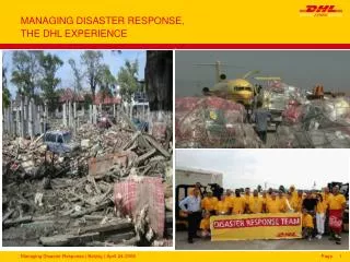
Managing the DR-1971-AL Tornado Disaster using GIS. Melissa Mayo GIS Specialist State GIS Unit Lead. Mike Vanhook GIS Coordinator ISD, Geospatial Office. April 27, 2011. 62 tornadoes statewide; 70 tracks Accumulative Damage path 1,177+ miles long 20+ miles wide 247 fatalities

E N D
Managing the DR-1971-AL Tornado Disaster using GIS Melissa Mayo GIS Specialist State GIS Unit Lead Mike Vanhook GIS Coordinator ISD, Geospatial Office
April 27, 2011 • 62 tornadoes statewide; 70 tracks • Accumulative Damage path • 1,177+ miles long • 20+ miles wide • 247 fatalities • Estimated damage cost is $1.1 billion • Estimated 10 million cubic yardsof debris
Individual & Public Assistance • 67 counties declared for public assistance • Emergency Work (Debris Removal & Emergency Protective Measures) • 43 counties declared for individual assistance • Assistance to individuals, families, & businesses with damages whose losses are not covered by insurance • 33 counties declared for permanent work aid • Repairing roads/ bridges, water control facilities, buildings & equipment, utilities, parks, recreational facilities, and other facilities • Tuesday November 15th: Day 202
Initial Map Requests at AEMA • Activated EOC’s • Reported Damage • Open Shelters • Resources Requested • Local State of Emergency • Aerial Imagery • Tornado Tracks/Swaths
Collaboration State Involvement Federal Involvement • GSA • ADECA • ALGO/ISD • ALNG • ACJIC • AFC • ADEM • FEMA USGS HDDS ACoE • NGA NOAA NWS
Collaboration • Local Contributions • County GIS • Municipality GIS • Private Entities • Atlantic Group: uploaded imagery to public site • Volunteer • Coordinated offers of assistance using spreadsheet • FTP Site Access CONFERENCE CALLS!!
AEMA Activation • GIS staff activation began at approximately 1800 hrs April 27, 2011 • AEMA uses 12 hr shifts during activations • Moved to this immediately
Disaster Operations for GIS • The following agencies & personnel supported AEMA to fill a GIS position after the tornado outbreak • AEMA GIS Intern, Kevin Taylor • Geological Survey of Alabama • Sandy Ebersole • Eric St. Clair • David Tidwell • ADECA • Henry Moore • Wardell Edwards • Anne Wynn • Tony Tavis • Meagan Rockman • University of Alabama • Linda Watson
GIS Coordination • Benefits of Coordinator outside AEMA GIS • Isolated from immediate needs of SEOC; could focus on broader GIS needs vs. specific needs at AEMA • Daily maps at AEMA vs. generation of tornado tracks • Easily identified external sources for GIS & Remote Sensing assistance (federal/state/ local) • Brenda Jones at USGS HDDS; State/ City GIS analysts • Tracked progress of work, maintained schedule for completion, & organized conference calls; provided daily summaries of available data sources • Conference calls to aid AEMA GIS with tracking work completed by other GIS; prevent duplicated efforts and provide data layers quickly • Ed Boyle & Maj. Simmons, AL National Guard; Kristin Frisbee, City of Montgomery; Lynn Ford, ADEM; AbiDhakal, AFC; Henry Moore, Wardell Edwards, ADECA; + others
GIS Coordination • The ISD Geospatial Office provided coordination assistance and enterprise support • Aggregated daily data sources and information • Maintained an email distribution list • Coordinated imagery collection and distribution • Supported NOAA and USGS HDDS imagery distribution • Coordinated working groups for large tasks or collections • Maintained a secure FTP for use among State agencies • Provided limited access to federal and local partners Primary Objectives: Ensure data and information exchange is open, frequent, accessible, and on time. Connect everyone that needs information. Provide a reliable record of resources that are readily available.
Imagery Acquisition • Imagery collected via various sources Posted publicly on USGS HDDS • Atlantic Group • NOAA Oblique Snapshots • ADEM • CAP
Special Projects GSA/ ADECA created mapbooks for 4 counties • Cullman, Madison, Tuscaloosa, West Jefferson • Utilized imagery as background • Digitized roads to help first responders locate areas of interest
GSA, ADECA, & AEMA created overview maps to show damage in specific areas
Joint Field Office • FEMA & AEMA work out of JFO for extended response to disasters • Centrally located for access to damaged areas • DR-1971-AL JFO located in Birmingham • GIS grouped with Planners for activations • AEMA GIS co-located with FEMA GIS • JFO closing date: November 9, 2011
Operation Clean Sweep • Identify areas with extensive or catastrophic damage • Local cost share became 90% Federal- 10% Local • Vs. usual 75% Federal & 25% Local cost share • National Geospatial Intelligence Agency (NGA) utilized commercial satellite imagery • Performed initial analysis of tornado swaths • “Turned on” approved US National Grid squares • Counties requested additional areas for consideration • Provided address and/or GPS coordinates NGA FEMA AEMA COUNTY LOCAL
Grids turned on during NGA initial sweep: 289 Final grid count after collaborative efforts: 960 Additional $$ leveraged thanks to collaborative efforts between State, County, & Local levels to have grids added
Operation Clean Sweep • Grid maps generated; provided to counties and municipalities • OCS concluded • July 12, 2011
Debris Verification • FEMA contracted with US Army Corps of Engineers to collect debris • Counties could either use USACE or their own contractor • AEMA GIS checked data reported by US ACE regarding debris locations • Mapped locations and determined whether they fell inside or outside of grids • 90/ 10 split of costs
Parcel Collection • Parcel data needed during initial response • FEMA estimated impacts • Also needed during later stages • FEMA funding to create historical buildings and districts layers • ADOR assisted with original collection for counties with tornado paths • AEMA & FEMA collaborated to collect rest
Parcel Collection • FEMA contractors created historical building and district shapefiles for most counties using parcels • Digitized Covington; digital parcel data is not available • Providing new data files back to counties
SUCCESS • Efficient collaboration among GIS professionals • Quickly assessed needs & organized projects • Delegation of tasks • Timely completion of products thanks to coordination
Thank You!!!! State County Municipal
Contact Information Melissa Mayo GIS Specialist Alabama Emergency Management Agency 205- 280-2440 melissam@ema.alabama.gov Mike Vanhook GIS Coordinator ISD, Geospatial Office 334-242-4799 mike.vanhook@isd.alabama.gov