Download
1 / 12
120 likes | 293 Vues
A Zonal Approach to National Height Modernization Gilbert J. Mitchell National Geodetic Survey Silver Spring, MD. National Spatial Reference System (NSRS) NSRS is a consistent coordinate system that defines latitude, longitude, height, scale, gravity, and orientation for the entire U.S.

E N D
A Zonal Approach to National Height Modernization Gilbert J. MitchellNational Geodetic SurveySilver Spring, MD
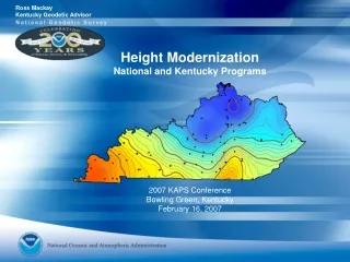
National Spatial Reference System (NSRS) • NSRS is a consistent coordinate system that defines latitude, longitude, height, scale, gravity, and orientation for the entire U.S. • NSRS components include national shoreline, CORS, network of horizontal and vertical monuments and a set of models that describe dynamic geophysical processes that affect spatial measurements
Height Modernization: • Height Modernization (HM) is the establishment of accurate, reliable heights using GPS technology in conjunction with traditional leveling, gravity, and modern remote sensing information
NOAA/NGS Partnerships • NGS’s mode of operation has migrated from agency staff doing the work to partnerships with state and local agencies, with NGS providing technical assistance • For some program areas, grant funds are made available to support federal share of costs
Zonal Approach - the General Idea • NOAA administers HM through lead states and Spatial Reference Centers • Lead states and SRC: • Organize states in zone to address common issues and problems • Serve as link between NGS and individual states • Seek opportunities to provide education and outreach concerning HM program and its benefits
DRAFT - DO NOT DISTRIBUTE Height Modernization Zones APPROACH • Northeast • Mid Atlantic • Gulf of Mexico • Great Lakes • Upper Plains • Lower Plains • Southwest • Northwest Leverage existing partnerships Validate proposed HM zones Evaluate needs and requirements Identify activities to be accomplished Solicit proposals for accomplishing activities Establish partnerships – multiple partner Promote “height technology transfer” Active regions – expand program in new regions
Zonal Plan Components • A National HM Steering Committee • Zonal pilot projects • HM forums in each zone • Regular zonal coordination meetings • Best practices workshops • Use of private sector resources (to conduct, manage, document, and evaluate HM projects, forums, and workshops) • Provide HM opportunities for all interested states • Provide R&D grants to state agencies and universities to support HM activities
Getting Started - Steps for Zonal Leaders • At this meeting we want to discuss with you: • Where we are with the Height Modernization Program • Where we want to be in 10 years • What we need to do to reach our mutual goals • In short, we want to hear your thoughts on how to best organize and carry out the ambitious goals of HM
Bringing New States into the HM Program • This is not an easy task, and we don’t have all of the answers, so your suggestions on how to accomplish the important goal of bringing new states on board are also very important
Support that NOAA/NGS Will Provide • Technical assistance (standards & specifications) • Speakers for forums at the zone and state level • Administration of grant funds provided by Congress • Adjustment of HM data and providing access to it on NGS website
Questions/Comments? • Thank You!