Asia
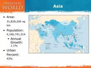
Asia. Asia is the largest of the world’s continents, covering approximately 30 percent of the Earth’s land area. It is also the world’s most populous continent, with roughly 60 percent of the total population. . What is Asia?.

Asia
E N D
Presentation Transcript
Asia Asia is the largest of the world’s continents, covering approximately 30 percent of the Earth’s land area. It is also the world’s most populous continent, with roughly 60 percent of the total population.
What is Asia? • Asia makes up the eastern portion of the Eurasian supercontinent; Europe occupies the western portion. • The border between the two continents is debated. However, most geographers define Asia’s western border as an indirect line that follows the • Ural Mountains • Caucasus Mountains • Caspian and Black Seas. • Asia is bordered by the Arctic, Pacific, and Indian Oceans.
Mountain Systems of Asia • The Himalaya mountains extend for about 2,500 kilometers (1,550 miles), separating the Indian subcontinent from the rest of Asia. • The Indian subcontinent, once connected to Africa, collided with the Eurasian continent about 50 million to 55 million years ago, forming the Himalayas. • The Indian subcontinent is still crashing northward into Asia, and the Himalayas are growing about 5 centimeters (2 inches) every year.
Himalayas • The Himalayas cover more than 236,000 square miles, passing through the northern states of India and making up most of the terrain of Nepal and Bhutan. • The Himalayas are so vast that they are composed of three different mountain belts. • The northernmost belt, known as the Great Himalayas, has the highest average elevation at 6,096 meters (20,000 feet). • The belt contains nine of the highest peaks in the world, which all reach more than 7,925 meters (26,000 feet) tall. This belt includes the highest mountain summit in the world, Mount Everest, which stands at 8,850 meters (29,035 feet).
Tien Shan Mountain System • Stretches for about 1,500 miles, straddling the border between Kyrgyzstan and China. • The name Tien Shan means “Celestial Mountains” in Chinese. • The two highest peaks in the Tien Shan are Victory Peak, which stands at 24,406 feet, and Khan Tängiri Peak, which stands at 22,949 feet. • Tien Shan also has more than 3,900 square miles of glaciers. The largest glacier is Engil'chek Glacier, which is about 60 kilometers (37 miles) long.
The Ural Mountains • Run for approximately 1,550 miles in an indirect north-south line from Russia to Kazakhstan. • The Ural Mountains are some of the world’s oldest, at 250 million to 300 million years old. • Millions of years of erosion have lowered the mountains significantly, and today their average elevation is between 3,000 to 4,000 feet. • The highest peak is Mount Narodnaya at 1,895 meters (6,217 feet).