Download

1 / 37
370 likes | 510 Vues
The Kootenai County and regional community resilience meeting held on September 18, 2012, focused on enhancing awareness and action against risks from flooding, earthquakes, and wildfires. The agenda included introductions, a review of completed projects, and a discussion on the Discovery Map. Critical topics included risk analysis, mitigation planning, and grant funding opportunities. Stakeholders provided input on necessary tools and resources to promote resilience within their communities, furthering collaboration among local, state, and tribal entities.

E N D
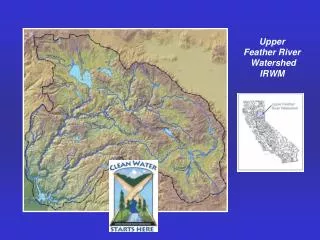
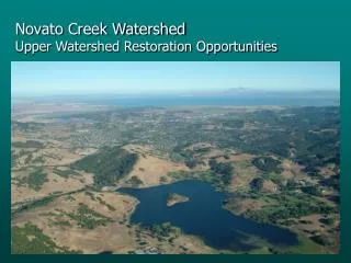
Community ResilienceUpper Spokane Watershed Kootenai County Resilience Meeting September 18th, 2012
Meeting Agenda • Welcome & Introductions • Meeting Goals • Discovery Map and Report • Flood First Pass Analysis • Risk Report Overview • Earthquake Update • Wildfire Review • Mitigation Planning • Report on Completed Projects • Grant Funding and Updating the Mitigation Plan • Next Steps/Next Scheduled Meeting
Introductions • Name • Title • Community
The Vision for Risk MAP Through collaboration with State, Local, and Tribal entities, Risk MAP will deliver quality data that increases public awareness andleads to action that reduces risk to life and property
Discussion Questions • What types of tools/materials does your community need to increase risk awareness? • How can FEMA and the State help you? • What capabilities does your community have/need to increase resiliency? • Administrative and Technical • Education and Outreach • Financial • Planning and Regulatory
Discovery Process • Meetings were held in May of 2012 with Kootenai County, City of Coeur d’Alene, City of Dalton Gardens, City of Hauser, City of Hayden, City of Hayden Lake, City of Rathdrum, and the City of Post Falls. • Identified hazards, outreach materials, mitigation and risk assessment needs and flood study needs • Engineering specific call with communities to discuss flood mapping issues • Draft report was created summarizing the community needs
First Pass Analysis • Methodology • Inventory of flooding sources (CNMS database, FIS) • Mileage of detailed and approximate riverine analyses • Date of effective analyses • H&H methods/models used • Availability of effective analysis data (digital, hard copy) • Needs assessment • Critical issues – re-study recommended in high-risk areas • Secondary issues – re-study may be recommended if certain issues are found • Availability of high-quality topographic data (LiDAR, 1 or 2-ft contours) – foundation for new RiskMAP studies
First Pass Analysis • Kootenai County Summary • Spokane River • Studies dated of 1976 (Spokane Co) and 1986 (Kootenai Co); • Hydrologic analyses, based on stream gage data, differ across state line, resulting in different effective discharges at WA-ID border; • Hydraulic analyses performed with models no longer supported (NRCS WSP2, USACE HEC-2) • Other flooding sources: • No new studies since 1986 • Unit runoff vs. drainage area curves used for Rathdrum Creek & Nettleton Gulch • No modeling used to map other streams • New USGS regression equations available since 2002
Risk Report • Draft Risk Report focusing on flood, earthquake, wildfire, and severe storm • HAZUS analysis was completed for flood losses • One page pullouts focusing on each disaster for citizens and developers
Risk Report: Flood Results Note: Loss Ratios are a useful gage to determine overall community resiliency.
To be included in the final draft: • Critical Facilities • Debris • Shelter/displaced households
ESFs and Risk MAP Handout • Provides a list of uses of Risk MAP products during Response Planning efforts
Earthquake Overview • National Earthquake Hazard Reduction Program (NEHRP) – FEMA/USGS/NIST/NSF • In support of the NEHRP Mission - FEMA provides • Increases local and State knowledge capacity on earthquake mitigation via training and technical assistance • Equip local communities with tools to support the planning and application of earthquake mitigation strategies • Support the implementation of approved earthquake mitigation special projects Low Risk Does Not Mean No Risk
Earthquake Overview 1872-2000- Instrumental Seismicity M>3.0 1969-2007- Instrumental Seismicity M>0.0
Earthquake Overview • Idaho Geological Survey - Fault Hazard Map
Earthquake Overview • Geological Map of Northern Idaho • Faults Identified • US History short & Seismic Monitoring History shorter “Low Risk Does Not Mean NO risk”
Earthquake Overview USGS Shakemap http://earthquake.usgs.gov/earthquakes/shakemap/ Scenario Earthquake-Not the real thing No ShakeMap doesn’t mean that the threat doesn’t exist.
Earthquake Overview • Training Available from FEMA • FEMA 154/ATC 20 : Property Inventory & Seismic Safety Inspection • FEMA 74: Non-Structural Mitigation • FEMA 596: Seismic Rehabilitation • FEMA 767: Earthquake Mitigation for Hospitals • FEMA 395: Earthquake Safety and Mitigation for Schools
Earthquake Overview • FEMA EMI Online Course, IS-325 - Earthquake Basics: Science, Risk, and Mitigation • QuakeSmartToolkit for Businesses, • Building Code Toolkit for local building officials, • More to come… • Resources and Supporting Materials Available at http://www.fema.gov/earthquake
Wildfire Hazard • Community Wildfire Protection Plan • Completed in 2006 • Prioritized mitigation actions
Wildfire Hazard • Community Wildfire Protection Plan • Completed in 2006 • Prioritized mitigation actions • Challenges • Accurate and up-to-date wildfire risk assessment
Wildfire Hazard:West Wide Wildfire Risk Assessment • Deliverables • Comprehensive Wildfire Database • Wildfire Risk Assessment • Final Report – Methods, Findings, and Using the Assessment Products • Model Outputs • Wildland Fire Susceptibility Index (Wildfire Threat) • Level of Concern Index (Wildfire Risk) • ID Contact: Andrew Mock, amock@idl.idaho.gov • Website: http://www.westwideriskassessment.com
Mitigation Planning • Kootenai County Multi-Jurisdiction All Hazard Mitigation Plan • Expires May 27, 2015 • Includes communities of:
Mitigation Planning Benefits • Identifies cost effective actions for risk reduction that are agreed upon by stakeholders and the public • Focuses resources on the greatest risks and vulnerabilities • Builds partnerships by involving people, organizations, and businesses • Increases education and awareness of hazards and risk • Communicates priorities to state and federal officials • Aligns risk reduction with other community objectives
Challenges to Achieving Mitigation Goals • Loss of interest or meeting fatigue after the end of the mitigation planning and adoption process • Lack of funding and other resources and capabilities • Insufficient political will to address the more complicated problems and controversial solutions • Apathy created by “disaster amnesia” or the perception that “nothing ever happens here • Mitigation strategy is not well connected with day-to-day operations
Actions Successfully Implemented • What actions have you successfully implemented in the past year? What contributed to its success? • Considering the information you heard today, do you have the capabilities to use this data? • Challenges • Opportunities
Recommendations for Success • Use the Post-Disaster Window of Opportunity • Focus on Quality over Quantity • Develop Strong Messaging • Encourage Local Champions • Identify a Mentor
Update on County Mitigation Plan • Action Item • Letter of Intent from communities who wants to be included in grant for the mitigation plan update
Next Steps • Final Risk Report • Outreach Materials • Mitigation Planning Technical Assistance When is the next Committee Meeting?
Contacts • FEMA Region X • Idaho • STARR Ted Perkins Regional Engineer Dwight.perkins@fema.dhs.gov 425-487-4684 Brett Holt Mitigation Planner Brett.holt@fema.dhs.gov 425-487-4553 Amanda Engstfeld Risk Analyst Amanda.Engstfeld@fema.dhs.gov 425-487-4626 Tamra Biasco Earthquake Program Manager Tamra.biasco@fema.dhs.gov 425-487-4645 Karen Wood-McGuiness NFIP Specialist Karen.Wood-Mcguiness@fema.dhs.gov 425-487-4645 Ryan McDaniel RiskMAP Coordinator Ryan.McDaniel@idwr.idaho.gov (208) 287-4926 Mary McGown NFIP Specialist Mary.McGown@idwr.idaho.gov(208) 287-4928 Mark Stephensen Hazard Mitigation Officer mstephensen@bhs.idaho.gov (208) 422-5726 Susan Cleverley State Mitigation Planner scleverl@imd.idaho.gov 208-422-6476 Becca Croft becca.croft@starr-team.com(425) 329-3699 Josha Crowley Josha.Crowley@starr-team.com(425) 329-3679
![Resilience Meeting: [Watershed Name]](https://cdn1.slideserve.com/2332628/resilience-meeting-watershed-name-dt.jpg)
![Resilience Meeting: [ Watershed Name]](https://cdn1.slideserve.com/2631471/resilience-meeting-watershed-name-dt.jpg)
![Resilience Meeting: [Watershed Name]](https://cdn3.slideserve.com/5383578/resilience-meeting-watershed-name-dt.jpg)