Download
1 / 34
340 likes | 360 Vues
Learn about the principles of air density and how it affects the movement of air masses. Discover the causes of wind systems and the influence of the Coriolis effect. Explore the global wind patterns and the role of the jet stream in weather systems. Explore the formation of cyclones and anticyclones. Understand the phenomena of Chinook winds and land breezes.

E N D
Air Density • Hot air is less dense than cool air (due to the activity of the molecules) • As heat is added to an air mass, the air molecules absorb energy and their activity or movement increases • This results in fewer air molecules per unit of volume in the atmosphere
Warm Air • Less dense, warm air tends to rise (this is why hot air balloons rise) • Additionally, hot or warm air is buoyant • Because of this increased molecular activity, the air is able to support greater amounts of other atmospheric components such as water vapor • Areas of warm, rising air have low atmospheric pressure
Cold Air • The number of air molecules per unit volume of atmosphere in cold air is greater • This causes heavier or more dense air which, due to gravity, has a tendency to sink to the earth’s surface • This creates high pressure areas • Cold air is less buoyant than warm air, as the air molecules are less active, so cold air masses are less able to hold water vapor and other atmospheric components
What causes wind systems? • The necessity to equalize pressure on the earth’s surface • Rising air in low pressure areas (warm air)must be replaced by air flowing in from high pressure areas (cold air) • Winds always blow from areas of high pressure into areas of low pressure • The greater the difference in pressure, the greater the velocity • This difference is called the pressure gradient (see weather and air pressure video)
The theoretical wind system • In theory, the global wind system would involve two giant cells of air movement, one in each hemisphere • The cells would be triggered by hot air rising at the equator and cold air flowing down from the polar regions to replace it • A low pressure system would exist at the equator (as air rises) and a high pressure system would exist at the polar regions (as cold air falls and presses down on the earth’s surface)
BUT… • The real way things happen are affected by many forces • The most important of these forces is the Coriolis effect
Global Winds • The two main factors in wind direction are the rotation of the earth (it turns from west to east) and the location of high and low pressure air masses. • In the northern hemisphere winds curve to the right. • In the southern hemisphere winds curve to the left.
Global Winds • This results in continual winds as the air flows from high presure to low pressure. • We have the trade winds which flow between 0 and 30 degrees. • The Westerlies which flow between 30 and 60 degrees. • The Easterlies which flow between 60 and 90 degrees. • Near the equator there are few winds and these are known as the Doldrums.
Coriolis Effect • As the earth rotates, we see the winds curving to the right in the Northern Hemisphere and the left in the Southern Hemisphere. This is the Coriolis Effect. (see Coriolis effect movie)
Surface Winds Remember: Air flows from HIGH to LOW pressure! • So in a low pressure system the winds flow counter clockwise= into the centre where the pressure is the lowest. • In a high pressure system the winds flow clockwise=away from the centre where the pressure is the highest. • This is reversed in the southern hemisphere.
The Jet Stream • Jet Stream: a fast moving (300 km/hr) air current that occurs in the atmosphere where the troposphere meet the stratosphere. • Migrates with the seasons. • Weather systems and temperatures are greatly influenced by the jet stream. • Moves from west to east. • Their path is meandering in nature and they mark the division between cold polar air and warm tropical air
Cyclones and Anticyclones • The waves or meanders in the jet streams are important in both the development of cyclones (low pressure systems) and anti cyclones (high pressure systems) (see video of ship caught in cyclone
The Jet Stream (video: “how does the jet stream work?”
Chinook winds: the snow eaters -Chinook winds are the result of colliding pressure fronts -Air pressure is lower at high elevation, and greater at low elevations. -When wind comes down off of the Rocky Mountains, the low pressure air collides with the high pressure air near the base of the mountains. -The moisture in the air condenses, warming the winds by releasing latent heat as the wind moves downhill to the east (see Chinook winds movie)
What is a land breeze? • Land breezes are the result of land heating during the day much faster than the ocean next to it • The warm air over the land will rise throughout the day, causing low pressure at the surface • Over the water, high surface pressure will form because of the colder air • To compensate, the air will sink over the ocean. • The wind will blow from the higher pressure over the water to lower pressure over the land causing the sea breeze • The sea breeze strength will vary depending on the temperature difference between the land and the ocean. (see video land breeze)
What is a sea breeze? • At night,the air over the ocean is now warmer than the air over the land • The land loses heat quickly after the sun goes down and the air above it cools too • The oceanis able to hold onto this heat after the sun sets and not lose it as easily • This causes the low surface pressure to shift to over the ocean during the night and the high surface pressure to move over the land • This causes a small temperature gradient between the ocean surface and the nearby land at night and the wind will blow from the land to the ocean creating the land breeze • (see video on sea breeze and land breeze)
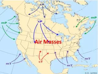
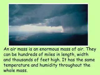
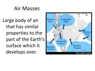
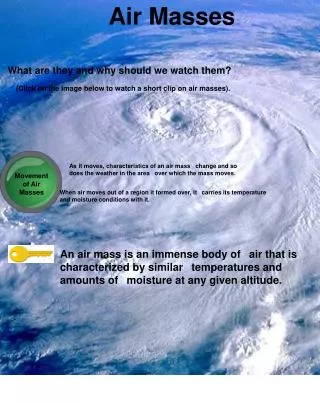
What is an Air Mass? • An air mass is a large body of air that is homogenous in terms of temperature and moisture. • A front is the leading edge of an air mass. • We have fronts because air masses cannot mix together.
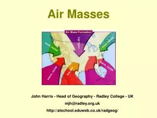
Classifying Air Masses • Air masses are classified according to their place of origin. • If they occur in the high latitudes they will be colder and therefore called arctic or polar. • If they occur in the low latitudes they will be warmer and therefore called tropical.
Classifying Air Masses • If an air mass begins over water and therefore contains a large amount of potential precipitation they will be called maritime. • If an air mass begins over large and therefore contains little to no water in it they will be called continental.
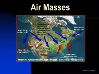
Air Masses over North America 1) Continental Polar • Originates in the vicinity of the North Pole and flows as far south as Florida. • Air in this air mass is very cold, stable and dry. • Cold air is more dense and stays in contact with the ground. • Clear, sunny skies and high pressure are common in this air mass.
Air Masses Over North America 2) Maritime Polar • Originates over the oceans and polar regions. • Often originates over the Gulf of Alaska. • It is cool, unstable and moist. • Brings a lot of the precipitation to BC in the winter. • Often the cold air is kept away by the mountain ranges. • When the two meet is when we mainly see our snow. (see “Windy weather wrecks havoc on Van Isle”)
Air Masses Over North America 3) Maritime Tropical • Originate over water in lower latitudes (Mexico-ish) • More stable than maritime polar air masses. • Sunny skies with some precipitation in the winter months. • When they are much warmer they can cause stormy conditions.
Air Masses Over North America 4) Continental Tropical • Originates over land in the lower latitudes (Texas). • Brings with it hot and dry conditions.
What is a weather front? • A weather front (or “front”) is a boundary separating two masses of air of different densities
Types of Fronts • Warm Front: leading edge of a warm air mass.
Types of Fronts • Cold Front: leading edge of a cooler front
Types of Fronts • Stationary Front: warm and cold air boundary that remains in one place
Types of Fronts • Occluded Front: cold front overruns a warm front mixing the air from the two
Practice 1) If a wind is called a westerlie it is flowing from the__________________. 2) There is little wind near the equator and this is known as the ____________. 3) If an air mass is composed of cold dry air it is _______________________. 4) If an air mass is composed of warm dry air it is______________________. 5) The coriolis effect causes winds in North America to flow ___________. 6) All winds flow from _____________ to _________pressure. 7) True or False. Areas located North of the jet stream will be colder than areas south of it.