Download
1 / 23
230 likes | 247 Vues
This article explores geospatial data models, OGC interfaces, and conceptual object models for spatial information. It also discusses the use of web interfaces for accessing and analyzing spatial data.

E N D
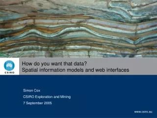
How do you want that data? Spatial information models and web interfaces Simon Cox CSIRO Exploration and Mining 7 September 2005
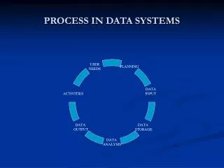
Outline • Geospatial datamodels • OGC interfaces Datamodels and interfaces
classic earth-observations “Coverage” viewpoint classic geology “Feature” viewpoint Fields vs. objects Datamodels and interfaces
Classic geometry-centric GIS approach • Points, lines and polygons are primary objects • Annotated with a set of attributes, often a row of scalar values • layer name => semantics Tenement • One shape per feature … • Really an implementation strategy, downplaying the business object Datamodels and interfaces
Digital objects correspond with identifiable, typed, objects in the real world mountain, road, specimen, event, tract Feature-type characterised by a specific set of properties each property is constant on the feature spatial values are just another property multiple geometries possible, e.g. scale dependence for single feature Properties include associations between complex objects i.e. the value of a property may be a complex object association-role == property 2. Conceptual object model: features Datamodels and interfaces
Variation of a property across the domain of interest For each element in a spatio-temporal domain, a value from the range can be determined c.f. features, where each property is constant Discrete or continuous domain Domain is often a grid Arc/Info “coverage” == multi-geometry domain, attribute-table for each element (x2,y2) 3. Spatial function: coverage (x1,y1) Datamodels and interfaces
A Row gives properties of one feature • A Column = variation of a single property across a domain (i.e. set of locations) Cross-sections through information Datamodels and interfaces
Description of observation event provides data acquisition “metadata” map from feature to property-estimate supports quality/confidence assessment, data processing 4. Data capture: the observation model Datamodels and interfaces
A Cell reflects the result of a single observation • A Row gives properties of one feature • A Column = variation of a single property across a domain (i.e. set of locations) Cross-sections through information Datamodels and interfaces
Properties Section view Map view • Point observations • Horizons • Intervals • Continuous logs • Samples Position is 1-D • arc-length from collar Sometimes they appear together • Collar (Point Property) • Shape (Curve Property) • Survey Datamodels and interfaces
Several views of the same information • Result/Observation view • Used for: • Quality/confidence assessment • Result calibration • Database insertion and update • Feature view • Assembled by: • Aggregation of multiple Observation/result having same featureOfInterest • Used for: • Object description • Coverage view • Assembled by: • Aggregation of multiple Observation/result having same observedProperty • Used for: • Property variation • Pattern/anomaly/feature detection Datamodels and interfaces
OGC Information Service interfaces • Web Map Service • Catalog Service • Web Feature Service • Web Coverage Service • Sensor Observation Service • Web Processing Service Datamodels and interfaces
private public boundary WFS Server WFS Client HTML GML • Data-source organised for custodian’s requirements • Community-specific GML application language • TigerGML, LandGML, O&M, XMML, CGI-GML, ADX, GPML, CSML, MarineXML etc Open Geospatial Consortium - Web Feature Service Datamodels and interfaces
Web Feature Service - operations • GetCapabilities • DescribeFeatureType • response: • GML schema for feature-type • GetFeature • request parameters: • Feature type • Property value • response: • Collection of feature instances of requested type • i.e. operation signature matches Feature-property information model Datamodels and interfaces
Web Coverage Service - operations • GetCapabilities • DescribeCoverage • response: • domainSet – spatial and temporal domains • rangeSet – component axis descriptions (though merely text strings …) • GetCoverage • request parameters: • domain subset • range subset – selected axes • i.e. operation signature matches Coverage/domain-Coverage/range information model Datamodels and interfaces
Sensor Observation Service - operations • GetCapabilities • DescribeFeatureOfInterest • DescribeSensor • GetFeatureOfInterest • GetFeatureOfInterestTime • GetObservation • GetResult • … • i.e. operation signature strongly based on Observation information model Datamodels and interfaces
Several views of the same information Datamodels and interfaces
SOS Server (observations) SOS Client WFS Server WFS Client WCS Server (coverages) WCS Client Data re-use • multiple views of same data (features) Datamodels and interfaces
WFS Client (analysis & reporting) WFS Server WFS Client SOS Server Sensor WFS/SOS Client/Server (orchestration) WFS Client(simulation) Combining with observation service (mapping) BPEL? Datamodels and interfaces
WFS Server B WFS Server WFS Client WFS Server C Standard transfer format allows multiple data sources Datamodels and interfaces
Mapping client http://cgsrv3.arrc.csiro.au/seegrid/savedapps/filter Three servers, one map GA DOIR PIRSA Datamodels and interfaces
Coverage • compilation of values of a single property across the domain of interest • data prepared for analysis/pattern detection • Feature • object having geometry & values of several different properties • 1. classified object, snapshot for transport • geological map elements • 2. object created by human activity, artefact of investigation • borehole, mine, specimen Value-adding chain • Observation/result • estimate of value of a property for a single specimen/station/location • data-capture, with metadata concerning procedure, operator, etc Datamodels and interfaces
Thank You Contact CSIRO Phone 1300 363 400 +61 3 9545 2176 Email enquiries@csiro.au Web www.csiro.au CSIRO Exploration and Mining Name Simon Cox Title Research Scientist Phone +61 8 6436 8639 Email Simon.Cox@csiro.au Web www.seegrid.csiro.au