Download
1 / 61
620 likes | 657 Vues
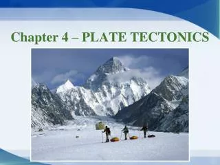
Explore the history and evidence behind continental drift theory and plate tectonics, from Suess to Wegener. Learn about Gondwanaland, Pangea, rock and fossil evidence, climate change indicators, and the Earth's layers. Engage with animations, ocean floor studies, and magnetic field analysis to understand seafloor spreading and geomagnetic time scales. Delve into the fascinating world of plate tectonics and the dynamic forces shaping our planet's surface.

E N D
Early Observations In the late 1800s, Eduard Suess, an Austrian geologist, hypothesized that the present southern continents had once been joined as a single landmass that he named Gondwanaland.
Continental Drift • In 1912, Alfred Wegener, proposed that in the distant past, Earth’s continents were all joined as a single landmass. • He called this supercontinent Pangea • He said that the continents have separated and collided as they have moved over Earth’s surface for millions of years.
Continental Drift • Wegener proposed that if the land areas were brought back together, the move would line up ancient mountain ranges, similar continental rock formations, and evidence of ancient glaciers. • There are even similar fossils on both sides of the Atlantic.
Continental Drift Animation: Plate Movement
Evidence: Rock Formations Some of the rocks of the Appalachian Mountains in the United States shared similar features with rocks in Greenland and Europe.
Evidence: Fossils • Similar fossils of several different animals and plants that once lived on land had been found on widely separated continents. • Reptiles that are only found in fresh water would not have crossed ocean waters. • Land-dwelling animals would not have swum that far of a distance. • Fern plant had been found on many continents that today, have very different climates.
Evidence: Climate Change Coal deposits had been found in Antarctica indicated that this land once had a temperate, rainy climate. Glacial deposits in Africa, India, Australia, and S. America suggested that these areas had once been covered by thick ice caps.
A Rejected Hypothesis • Wegner’s hypothesis had two flaws: • 1. He could not explain what was causing the continents to move. • He suggested that the rotation of Earth could be possible, but physicists were able to show that this force was not great enough. • 2. He could not explain how the contents were moving. • He suggested that the continents were plowing through a stationary ocean floor, but geologists argued that continents could not push through the ocean floor without fracturing and there was no evidence of such fracturing.
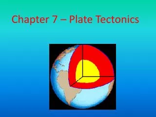
The Earth’s Layers • The Crust • Varies from 5-60 KM • In most places, a thin layer of sedimentary rocks covers the mostly granite-like rocks of the continental crust • The oceanic crust, under layers of marine sediments, is composed of darker and denser rocks similar to basalt
The Earth’s Layers • The Mantle • Extends to a depth of about 2900 KM. • Earthquake waves travel faster in the mantle than they do in the crust. • Composed mostly of dense, the dark mafic minerals olivine and pyroxene.
The Earth’s Layers • The Core • Composed of iron and nickel. • Outer Core is thought to be liquid because S-waves are unable to pass through the outer core. • The Inner Coreseems to be solid.
Seafloor Spreading • Advancement in technology allowed scientists to study the ocean floor • Sonar: use of sound waves to measure water depth • Magnetometer: device that can detect small changes in magnetic fields
Evidence from the Oceans • In the 1950’s both fossils and the analysis of radioactive material showed the age of the oceanic crust increases with distance from the mid-ocean ridges. • Some oceans were growing wider from the middle. • Scientists also used magnetic measurements of the oceanic crust.
Ocean Floor Topography • Ocean ridges: underwater mountain chains • Mid-Atlantic Ridge, East Pacific Rise • Trenches: narrow, elongated depression in the seafloor with very steep sides • Mariana Trench (deepest)
Ocean Rocks & Sediments • 1. ages of rocks vary in different places • Age of oceanic crust consistently increases increases with distance from a ridge • Rock near ocean ridge = younger • Rock near trenches = older
Ocean Rocks & Sediments • 2. the thickness of ocean-floor sediment is much less than expected • Ocean floor sediments = a few hundred meters thick • Continents = up to 20kilometers thick
Critical Thinking • Question: • Why aren’t seafloor sediments as thick as continental sediments? • Answer: • thickness of sediments increases with distance from an ocean ridge • Sediments are thicker closer to trenches b/c the sediment supply is greater than it is near ocean ridges, which are often located in the middle of the ocean (hence, not as thick).
Magnetism • Paleomagnetism: the study of Earth’s magetic field record . • Basalt is rich in iron-bearing minerals, therefore, provides an accurate record of ancient magnetism. • As basalt cools, the iron-bearing minerals become oriented parallel to Earth’s magnetic field.
The Geomagnetic Time Scale • Earth’s magnetic field periodically reverses (magnetic reversal) • Different ages provide a record of when the Earth’s magnetic field reversed its polarity.
Magnetic Symmetry • Scientists noticed that the positive and negative areas formed a series of stripes that were parallel to ocean ridges. • Scientists were able to determine the age of the ocean floor from magnetic readings and create isochron maps.
Isochron Map Isochron: a line on a map that connects points that have the same age.
Seafloor Spreading • Harry Hess proposed a theory called seafloor spreading which states that new ocean crust is formed at ocean ridges and destroyed at deep-sea trenches. • Magma is forced up toward the crust along an ocean ridge and fills the gap that is created. • When magma hardens, a small amount of new ocean floor is created
The Missing Link • Seafloor spreading was the missing link needed by Wegner to complete his model of continental drift. • Provides the answer of how these landmasses move
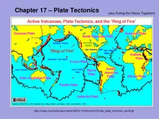
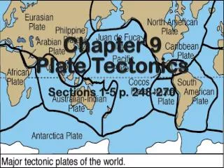
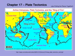
Plate Tectonics • The surface of Earth is composed of about a dozen major rigid, moving crustal plates and several smaller plates. • These plates contain areas of light continental rock and dense oceanic bottoms.
Plate Boundaries • Tectonic plates interact at places called plate boundaries. • Each type of boundary has certain geologic characteristics and processes associated with it.
Convergent Boundary • Convergent boundaries occur from converging plates • plates that are moving toward each other.
Convergent Boundary • Subduction occurs when a dense oceanic plate dives beneath a lighter continental plate. • Subduction forms ocean trenches that are linear fractures and are the deepest parts of the oceans.
Three Types of Convergent Boundaries • 1) Oceanic-Oceanic • One of the two plates is subducting beneath the other • Creates a deep-sea trench • The subducted plate descends into the mantle and melts which is then forced back to the surface • forms and arc of volcanic islands • ie: Mariana Trench/Islands & Aleutian Trench/ Islands
Oceanic-Oceanic Examples Mariana Trench Philippine Plate subducting under the Pacific Plate Aleutian Trench Pacific Plate is being subducted under the North American Plate
Three Types of Convergent Boundaries • 2) Oceanic-Contintnetal • Denser oceanic crust is subducted • Creates trench & volcanic arc… insead of arc of volcanic islands, a series of volcanoes erupt along the edge of the continental plate • Mountain range with many volcanoes • ie: Andes Mountains & Peru-Chile Trench
Oceanic-Continental Example Peru Chile Trench Nazca Plate is being subducted under the South American Plate
Three Types of Convergent Boundaries • 3) Continental-Continental • Colliding edges of the continents are crumpled and uplifted to form a mountain range • ie: Himalayas Indian Plate is colliding with the Eurasian Plate. (no subduction)
Convergent Boundaries Plate Boundary Movement
Divergent Boundary • A divergent boundary (rift) is found at the mid-ocean ridges where upwelling material creates new crust that moves away from the ridge in both directions.
Divergent Boundary • Over millions of years, seafloor spreading along a divergent boundary may cause an ocean basin to grow wider. • Atlantic Ocean = 2-3 cm/yr Atlantic Ocean Growing Animation • Some divergent boundaries may form rift valleys: when continental crust begins to separate, the stretched crust forms long, narrow depression. • East Africa -
Plate Boundaries • When a plate slides horizontally past another plate, they meet at a transform boundary.
Transform Boundary • Characterized by long faults, sometimes hundreds of km long, and by shallow earthquakes • Most offset sections of ocean ridges • Rarely do transform boundaries occur on continents. • San Andreas Fault is the exception
What Moves the Plates? • The transfer of thermal energy by the movement of heated matter is called convection. • The heating of matter causes it to expand and to decrease in density. • The warmed matter then rises. • The cooler part of the matter sinks. • This up-and-down flow produces a pattern of motion called a convection current.
Push & Pull • How is mantle convection related to the movement of tectonic plates? • The weight of the uplifted ridge is thought to push an oceanic plate toward the trench formed at the subduction zone called ridge push. • The weight of a subducting plate helps pull the trailing lithosphere into the subduction zone in a process called slab pull.
Earthquakes • Any vibrating, shaking, or rapid motion of the Earth’s crust. • Most occur when stress builds along a zone of weakness or a break in the rock known as a fault. • When the crust shifts, energy is released. • The energy radiates in all directions through vibrations.
Hot Spots • In several places on earth, hot plumes of magma pierce the crust. • As a crustal plate moves over this source of magma, volcanoes form at the hot spot. • This movement of a plate leads to the formation of a chain of volcanoes of differing ages. • One example is the Hawaiian Islands.
Volcanic Hazards • When volcanoes erupt they may spew hot lava, hot ash, and/or toxic gases. • The lava and ash can bury cities, and the toxic fumes can suffocate people. • Volcanoes can also provide fertile soil that is composed of weathered volcanic material.
Earthquakes • The place underground where the break occurs is the focus of the earthquake. • The epicenter is the location at the Earth’s surface just above the focus.
Measuring Earthquakes • Magnitude (Richter Scale) • Seismographs are the most reliable measures of earthquakes. • Each increase in one unit of magnitude means a ten-fold increase in shaking. • Intensity (Mercalli Scale) • Based upon the reports of people who experienced the earthquake and observed the destruction.