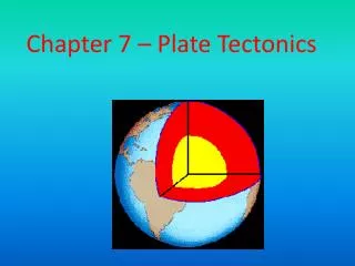
Chapter 7 – Plate Tectonics
Chapter 7 – Plate Tectonics. I. Inside the Earth . A. Crust. 1. The crust is the Earth's outermost surface. 2. It is typically about 25 miles thick beneath continents. 3. The crust is relatively light and brittle.

Chapter 7 – Plate Tectonics
E N D
Presentation Transcript
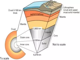
A. Crust 1. The crust is the Earth's outermost surface • 2. It is typically about 25 miles thick beneath continents • 3. The crust is relatively light and brittle. 4. Both continental and oceanic crust are made mainly of the elements oxygen, silicon and aluminum. Both continental crust and oceanic crust are made mainly of the elements oxygen, silicon, and aluminum. However, the denser oceanic crust has almost twice as much iron, calcium, and magnesium, which form minerals that are denser than those in the continental crust.
The region just below the crust and extends all the way down to the Earth's core. B. Mantle • 2. It is much thicker than the crust and contains most of the Earth’s mass. • 3. Contains more magnesium and less aluminum and silicon than the crust 4. It is denser than the crust
C. Core 1. Beneath the Mantle • 2. Consists of a fluid outer core and a solid inner core. • 3. Because the outer core contains iron, when it flows it generates a magnetic field. 4. Source of the Earth's magnetic field.
Layers of earth Structure of the Earth
D. Lithosphere and Asthenosphere 1. The Earth's lithosphere (crust and upper mantle) 2. The asthenosphere is the zone of the Earth's mantle that is under the lithosphere and consist of several hundred kilometers of deformable rock on which the tectonic plates move. 3. Made of solid rock that flows very slowly
E. Plate Tectonics Plate tectonics 1. In 1912, Alfred Wegener came up with a hypothesis of continental drift. 2. He noticed that all of the continents seemed to fit together like the pieces of a giant puzzle.
F. Theory of Continental Drift 1. Wegner thought the continents were once all joined 2. Over time, separated
Theory of Continental Drift 3) He decided to give this supercontinent a name and called it Pangaea, meaning, "all lands". 4) He had some fossil evidence to support this idea. 5) Other scientists thought he was just plain crazy because he couldn’t prove HOW they moved.
6. Seafloor spreading is the process by which new oceanic lithosphere forms as magma rises to the surface and solidifies.
G. New Technology Helps Wegener: • Sonar led to finding a long, unbroken mountain chain of undersea volcanoes . • Instruments which measure earthquake activity around the world began plotting the locations of Earth’s earthquakes. • Volcanic and seismic (earthquake) activity was found to be concentrated along certain areas that looked like the margins of huge crustal plates.
II. Tectonic Plate Boundaries A. Plate tectonics – A theory 1. that the Earth’s lithosphere is divided into tectonic plates 2. Move and change shape on top of the asthenosphere
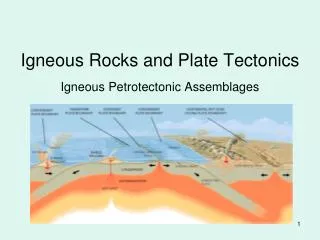
B. Convergent Boundary 1. Formed by the collision of two lithospheric plates 2. Three types Continental – continental boundaries c. Continental – oceanic boundaries b. Oceanic-oceanic boundaries
C. Divergent boundary 1. Boundary between two tectonic plates that are moving away from each other 2. Mid-Ocean Ridges are most common
D. Transform boundary 1. Boundary formed when plates slide past each other horizontally 2. Have irregular shapes --grind and jerk – produces earthquakes 3. San Andreas Fault in California is a good example
E. Possible cause of Tectonic Plate motion 1. Movement of solid rock of asthenosphere flows very slowly 2. This is because of a change in density within asthenosphere 3. Rock is heated – expands and becomes less dense 4. Tends to rise to surface of the Earth 5. Rock cools as it gets closer to surface and becomes more dense – then tends to sink
II. Deforming the Earth’s Crust A. Deformation – process by which the shape of a rock changes because of stress Bending Breaking
3. Compression –forces act to squeeze an object 4. Tension – forces act to stretch an object
B. Folding – bending of rock layers because of stress Anticlines – upward-arching folds Synclines – downward, troughlike folds Monocline – rock layers folded so both ends are horizontal
C. Faulting 1. Fault – break in a body of rock along which one block slides relative to another 2. Normal fault – tectonic forces cause tension that pulls rocks apart
3. Reverse Faults – tectonic forces cause compression that pushes rocks together
4. Strike-slip faults – opposing forces cause rock to break and move horizontally Example : San Andreas fault in California