Download
1 / 22
220 likes | 339 Vues
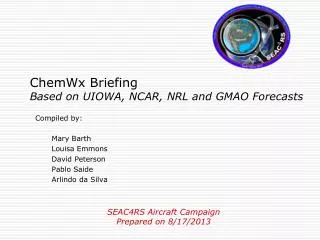
This briefing outlines the current conditions of aerosols and fire activities based on forecasts from UIOWA, NCAR, NRL, and GMAO, prepared on August 17, 2013. It highlights ongoing large fires, pyroconvection, and significant smoke transport across regions. The forecast predicts substantial CO levels at 700 hPa on August 19, with most aerosol trajectories from Idaho fires moving eastward. It includes insights into the isoprene levels across the SE US and the impact of these factors on air quality, alongside the outlook for fire weather in the western CONUS.

E N D
ChemWx Briefing Based on UIOWA, NCAR, NRL and GMAO Forecasts Compiled by: Mary Barth Louisa Emmons David Peterson Pablo Saide Arlindo da Silva SEAC4RS Aircraft Campaign Prepared on 8/17/2013
Aerosols Friday 8/16 clouds aerosols
Current Fire Activity • Several ongoing large fires and recent pyroconvection • Many new fires! • Large-scale smoke transport is still occurring…
Current Fires Past 24 hrs (Some of the Largest): Primary smoke producers
Biomass Burning CO and Aerosols Forecsts for Monday 8/19
CO at 700 hPa Monday 8/19 at 18Z
Flexpart Trajectories from Idaho fires – mostly going eastward Between 5-10 km altitudes 24 hr trajectory injected at 3-7 km, ending 08-19 1800UTC 24 hr trajectory injected at 3-7 km, ending 08-19 1800 UTC at 44N 48 hr trajectory injected at 3-7 km, ending 08-19 1800UTC
24 hr trajectory injected at 3-7 km, ending 08-19 1800UTC Flexpart trajectories released 9-11 km altitude ending 08-19 1800 UTC 48 hr trajectory injected at 3-7 km, ending 08-19 1800UTC
Isoprene occurring throughout SE US WRF-Chem in AR-MO is 5-10 ppbv at 925 mb MOZART tracer over 1 ppbv Models not consistent south MO, AL, GA, consistent otherwise Isoprene 925mb 18UTC Monday 8/19 at 18Z
Mon 8/19 Birmingham plume Main plume headed northward Lofted to 4km and higher 34N 87W
Mon 8/19 Plumes from coastal cities carried inland.
Upper Troposphere: Both PBL and ST air over southern and SW US WRF-chem CO at 200 hPa At 08-19 1800 UTC WRF PBL tracer at 12 km WRF PBL tracer 8-14 km WRF ST tracer at 12 km
Mon 8/19 Convected tracers SE U.S. at 300 hPa -- a mix of ocean, biogenic and anthropogenic tracers
Smoke/Aerosol Forecast View slide for animation!!!
Summary • Fires • Large fires will still be burning in the western CONUS, especially in Idaho • Fire weather conditions will remain favorable for growth • Convection potential will decrease the central CONUS • Southeast US • Temperatures still below climatology on Monday, warming up by Wednesday • NAM • Both PBL and Strat air over southern and SW US • SE U.S. at 300 hPa -- a mix of ocean, biogenic and anthropogenic tracers