Beijing Economic Census GIS
Beijing Economic Census GIS. Evelyn Sun evelyn.sun@supermap.com.
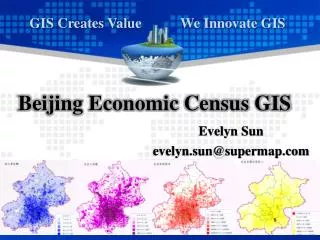

Beijing Economic Census GIS
E N D
Presentation Transcript
Beijing Economic Census GIS Evelyn Sun evelyn.sun@supermap.com
The state council of China stipulated the objective of the 2nd national economic census was to “establish and enhance the inventory database for all industries, the foundation information database, and census geographical information systems.”
Desktop Census GIS: Query, Present, Analyze, and Update Data
Stage 1: Census Area Partition and Digital Mapping • Collect map data: 1: 50,000 Vector Map from State Bureau of Surveying and Mapping 1: 2,000~ 1:500 Vector Map from City Surveying and Mapping Department 2m~0.61m Satellite Imagery Paper Maps(Must be digitized) • Define and Delineate enumeration boundaries; • Encoding each building • Print and Distribute maps to enumerators
Coverage 6,404 Neighborhoods 1City 1,270,000 Buildings 319 Towns 19 Districts
Saved efforts… • Paperless • Standardized mapping • Improved accuracy • Reduced manpower/cost
eSuperMap iMobile FieldMapper Silverlight Flex Ajax Realspace Web Mapping IS .NET iServer Java Web GIS Objects Objects .NET Objects Java Dev Tools Desktop Desktop .NET Desktop 类库内核 SFC(COM) UGC(C++) SuperMap Products 空间数据引擎 SuperMap SDX+ RDBMS XML File Database