Download
1 / 36
370 likes | 599 Vues
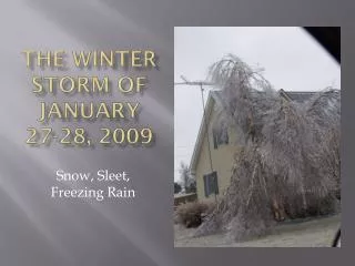
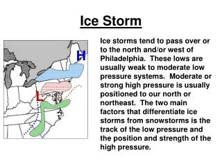
The Historic Ice Storm of January 26-28, 2009 . Pat Spoden , Daniel Spaeth , Mike York, Robin Smith, Shane Luecke , Beverly Poole, Christine Wielgos. Memphis AMS/NWA Presentation – Feb. 2010. The Historic Ice Storm of January 26-28, 2009 . OUTLINE Brief review of the storm

E N D
The Historic Ice Storm of January 26-28, 2009 Pat Spoden, Daniel Spaeth, Mike York, Robin Smith, Shane Luecke, Beverly Poole, Christine Wielgos Memphis AMS/NWA Presentation – Feb. 2010
The Historic Ice Storm of January 26-28, 2009 OUTLINE • Brief review of the storm • Review of the environment and forcing (Why was it so bad?) • Latent heating just about saves the day! • Lessons Learned
The Historic Ice Storm of January 26-28, 2009 • UNIQUE IMPACT • (THIS TIME IT WAS PERSONAL) • The ice storm impacted each and every member of our staff significantly. • I was without power for 5 days. Some were out for 21 days! Sent my family to Atlanta – I had to work. • Kids in school for a full week while many were without power.
January 26-28, 2009 Ice Storm Radar 6 PM Monday 12 AM Tuesday KPAH Reflectivity & METARs
January 26-28, 2009 Ice Storm Radar 6 AM Tuesday 12 PM Tuesday KPAH Reflectivity & METARs
January 26-28, 2009 Ice Storm Environment 850-700mb Theta-e Conv. 800mb Wind Midnight Monday
January 26-28, 2009 Ice Storm Environment 850-700mb Theta-e Conv. 800mb Wind 6 AM Tuesday
January 26-28, 2009 Ice Storm Environment 850-700mb Theta-e Conv. 800mb Wind PM Tuesday
January 26-28, 2009 Ice Storm Environment 850-700mb Theta-e Conv. 800mb Wind 6 PM Tuesday
January 26-28, 2009 Ice Storm Environment 850-700mb Theta-e Conv. 800mb Wind 12 AM Wednesday
January 26-28, 2009 Ice Storm Environment Sounding At KPAH (GFS) 6 PM Monday
January 26-28, 2009 Ice Storm Environment Sounding At KPAH 12 AM Tuesday
January 26-28, 2009 Ice Storm Environment Sounding At KPAH 6 AM Tuesday
January 26-28, 2009 Ice Storm Environment Sounding At KPAH 12 PM Tuesday
January 26-28, 2009 Ice Storm Environment Sounding At KPAH 6 PM Tuesday
January 26-28, 2009 Ice Storm Environment Sounding At KPAH 12 AM Wednesday
January 26-28, 2009 Ice Storm Latent Heat Concerns 2 AM 10 PM 12 AM When water freezes it goes from liquid to solid phase. Liquid is a higher energy state than solid, so energy will be released when this transition occurs. The energy is in the form of heat which warms the air.
January 26-28, 2009 Ice Storm The Perfect Storm • Sub-freezing air in place for over 72 hours before storm. • Persistent southwest flow aloft with cool northeast flow at the surface. • Persistent low-level forcing for lift, with lots of moisture streaming into the region. • No instability lighter rain rates efficient icing • Latent heating continuously offset by cool northeast surface flow. Temperatures staying at or below freezing.
January 26-28, 2009 Ice Storm Forecast Confidence Persistent trends in successive runs of a single model. 24+ hours of consistency leads to increased confidence. Personal experience can lead to forecast confidence. “I’ve seen this many times.” – pattern recognition. Clustering of the operational models around a common solution. #3 is a baby step toward Ensemble Forecast Systems.
January 26-28, 2009 Ice Storm Forecast Confidence Long Term • Noticed this pattern on 4 runs of the GFS over a 2 day period. European model very similar. • Recognized the pattern as one that could lead to an unpleasant winter scenario for our area. • Aware that these models typically depict major large-scale events very well and very early (7-10days out).
January 26-28, 2009 Ice Storm Forecast Confidence Long Term AREA FORECAST DISCUSSION NATIONAL WEATHER SERVICE PADUCAH KY 125 PM CST TUE JAN 20 2009 .LONG TERM /FRIDAY NIGHT THROUGH TUESDAY/... SIGNIFICANT WINTRY PRECIPITATION LOOKING MORE LIKELY AT SOME POINT THE FIRST HALF OF NEXT WEEK. HAZARDOUS WEATHER OUTLOOKNATIONAL WEATHER SERVICE PADUCAH KY324 PM CST TUE JAN 20 2009.DAYS TWO THROUGH SEVEN...WEDNESDAY THROUGH MONDAYASIGNIFICANT WINTRY PRECIPITATION EVENT IS POSSIBLE DURING THE FIRSTHALF OF NEXT WEEK ILZ094-KYZ005>009-011-211030-MASSAC-MCCRACKEN-GRAVES-LIVINGSTON-MARSHALL-CALLOWAY-LYON-INCLUDING THE CITIES OF...METROPOLIS...PADUCAH...MAYFIELD...SMITHLAND...BENTON...MURRAY...EDDYVILLE302 PM CST TUE JAN 20 2009 .MONDAY THROUGH TUESDAY...MOSTLY CLOUDY WITH A 40 PERCENT CHANCEOF RAIN OR SNOW. HIGHS IN THE UPPER 30S. LOWS IN THE UPPER 20S.
January 26-28, 2009 Ice Storm SREF Signs of a Big Event SREF 9 AM Monday Chance of FZRA & 1”/24 hrs QPF Valid 6 PM Tuesday
January 26-28, 2009 Ice Storm SREF Signs of a Big Event • The GFS and ECMWF nailed the synoptic setting for the event 7 days ahead of time. • Model QPFs averaging ~2.5”. • Strong signal for 1” and 2” 24 hour QPFs in the SREF. • Extreme QPF collocated with high probability of freezing rain in SREF. • SREF Mean indicating 250% of normal precipitable water with no instability.
Are You Really Prepared? Tree damage in Western KY: 3.5 million cubic yds $185-231M in Kentucky alone 769,000 power outages and at least 36 deaths in KY The costliest disaster in Kentucky's history - Courier-Journal It was an interesting event in many ways… Plus 5 counties In SW Indiana Disaster Declarations
Preparation • Have an up-to-date disaster kit • Gas up your vehicles • Have cash on hand • Think about your pets • Test your backup generator - fill with gas • Fill extra gas cans for generator and vehicles • Have a plan for what to do with your family if you have to work • Prepare for no communications – HAM radio? • Create a plan in the event you cannot contact everyone (Call down chart ): We had 1 person MIA for a period of time
During storm… • Use ice/snow to pack coolers of frozen – refrigerated foods • Fill bathtub with water to use in toilets • If you have a camper or motor home – set this up as residence • Gas fire logs (non vented) to heat homes • Monitor radio for possible shelters, places to buy gas/groceries, updates to power situation. • Monitor damage area for signs of improvement in order to get what you need • Check on neighbors/friends – lend a helping hand when you are able
The Historic Ice Storm of January 26-28, 2009 Will it ever happen again? Not likely, but….. It could happen this season or next!