
RRT3 Delmarva TTx
E N D
Presentation Transcript
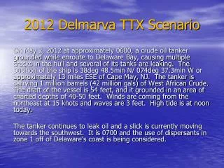
RRT3 Delmarva TTx Subject: Initial ReportFrom: Ed LevineDate: 5/2/2002--------At approximately 0715 EDT the T/V CRUDE TARGET grounded while enroute into Delaware Bay. The position of the ship is 38deg 48.5min N/ 074deg 37.3min W or approximately 13 miles ESE of Cape May, NJ. The vessel draws 54 feet but grounded in an area of charted depths of 40-50 feet. The ship is carrying 1 million barrels (42 million gals) of West African Crude. No oil is leaking at this time. Weather forecasts indicated severe thunderstorms and gusty winds, however, they are predicted to be from the west with 4-6 foot seas. High tide is at 0020 tonight. ISSUES: Large Spill-1million barrels-42 million gallons Tourist Season starts in 3 weeks Piping Plovers on the beach Horseshoe Crab Nesting in progress Shorebird Migration in two weeks Fishing/Recreational Season in progress
Crude Target Grounding 2May2002 Draft=54 ft, Charted depth=40-50ft, Carrying 42 million gal of West Africa Crude
Oil Impact Area Fenwick Island To Cape Charles