Observed Climate Variability and Change
This overview explores climate variability and change, focusing on key indicators such as trace gases, temperature, sea ice, precipitation, and extreme weather events like tropical cyclones and tornadoes. Notably, carbon dioxide levels have surged from 280 ppm at the start of the Industrial Revolution to around 380 ppm today. The paper examines historical temperature records, highlighting a marked warming trend, especially since 1976, with significant increases in warm nights and a reduction in freezing days. These changes have critical implications for climate policy and adaptation strategies.

Observed Climate Variability and Change
E N D
Presentation Transcript
Observed Climate Variability and Change Jay H. Lawrimore NOAA’s National Climatic Data Center Asheville, North Carolina
Overview • Trace Gases • Temperature • Sea ice/Snow Cover/Sea Level • Precipitation/Drought • Tropical Cyclones/Tornadoes • New Transportation-related activities
Trace Gases – CO2 and CH4 • CO2 has increased from ~280 ppm at start of industrial revolution to ~380 ppm today • 2005 global avg: 378.9 ppm • Since 1900, there has been a 22% increase • Avg annual increase of 1.6 ppm since 1980 • Rate of CH4 increase has slowed in recent years • Global mean: 1774.8 ppb in 2005 CO2 - Mauna Loa CH4 - Mauna Loa
Trace Gases – N2O and SF6 SF6 N2O • Present in lower concentrations than CO2 • Radiative forcing per molecule is much greater • SF6: 22,000 more times effective IR absorber • Total radiative forcings relatively small • Rapid growth rates and IR absorbing effectiveness = concern for future • SF6: ~5%/year increase since 1996 • N2O: 0.25%/year since 1978
1000-Year Temperature Record Jones, PD & ME Mann, 2004. Climate Over Past Millenia. Reviews Of Geophysics 42 (2): Art. No. RG2002 Temperature reconstruction created from tree rings, ice cores, ice melt, corals, lengthy instrumental records.
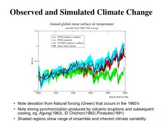
New NOAA/NCDC Land & Ocean Blend Global Mean Temperature over Land & Ocean Preliminary: New NOAA Surface Temperatures • Global surface temperature above 1998 record without strong El Niño episode • Continuation of steep warming trend brought global temperature to 1998 levels in only 7 years • 9 of 10 warmest years on record have occurred since 1995
New NOAA/NCDC Land & Ocean Blend Global Mean Temperature over Land & Ocean Preliminary: New NOAA Surface Temperatures • No one year definitively warmest on record • Sampling, Random and Bias Errors analyzed to estimate uncertainty in annual anomalies • Sampling and Random Errors decrease with time due to improved coverage and better instruments and measurement techniques
Global TemperaturesLand, NMAT, SST • Temperature changes over 20th century are extremely consistent across land and oceans • Both show pronounced warming in 2 phases • 1915-1945 and 1976-present • Much stronger warming over land in current period • Continental warming in mid-latitude Northern Hemisphere • Likely due to atmospheric circulation changes in winter half • Oceanic cooling in S. Hem. • Possibly due to Pacific Decadal Oscillation & AAO
Annual Temperature Trends 1901 - 2005 1979 - 2005 Deg C/Decade • Increasing temperatures across most land and ocean surfaces • 1901-2005, warming is global with a few exceptions, e.g. Southeast US and N. Atlantic • 1979-2005, warming largest in mid & high latitude regions of N.H. • 1979-2005, portions of southern oceans show cooling
Tropospheric Temperatures1958-2005 1979-2005 RATPAC: +0.15C/decade (+0.15C*) HadAT2 LT: +0.16C/decade (+0.15C*) UAH LT: +0.13C/decade (85N-50S) *Decadal trend since 1958
Global Max and Min Temperature1950-2004 • Minimum temperatures rising faster than maximum • Overall Trends 1950-present • Min: +0.20C/decade • Max: +0.14C/decade • Trends 1979-present • Min&Max: +0.29C/decade • Cloud cover & Precip trends accounted for >80% of variance in DTR in U.S., Australia, mid-Latitude Canada, and former Soviet Union
Affect of Warming on Temperature Extremes • Warm nights • Minimum daily temp >90th percentile • Globally- Annual #warm nights increased ~25 days since 1951 • Largest over Eurasia • Doubling over N. Africa, N. South Am. Alexander et al. 2005 • 1951-2003; At least 40 yrs of data required • 74% of sampled land area showed an increase in warm nights
Affect of Warming on Temperature Extremes • Warm days • Maximum daily temp >90th percentile • Increasing trend not as large as #warm nights • Larger areas of decreasing trends Alexander et al. 2005 • 1951-2003; At least 40 yrs of data required • Black lines enclose regions where trends significant at 5% level
Temp and Apparent Temp Trends in US(June-August, DegC/Decade) Gaffen and Ross, 1998
Temperature Summary • Global mean temperatures increased at a rate of 0.6 – 0.7 C/century since 1900 • Much more rapid warming since 1976 • Similar trends on land and oceans • Temperatures increasing in troposphere • Minimum temperature rising faster than maximum temperature since 1950 • Other effects • Lengthening the freeze and frost-free seasons in many mid- and high-latitude regions • Widespread decreases in number of days below freezing • Increases in number of warm days and nights
Arctic Climate • Arctic-wide annual avg anomalies (60N-90N) • Large region-to-region differences in 1930s • More widespread and stretching into mid-latitudes in 1990s and beyond
Arctic Sea Ice Extent – March/September 7% Decrease in end-of-summer Arctic sea ice in past 25+ years March Mean Extent: 15.7 Million km2; 2005: 14.8 Million km2 Sept Mean Extent: 6.9 Million km2; 2005: 5.6 Million km2 • Rate of decrease in March: -2%/Decade • In September: -7%/Decade
Arctic Sea Ice Extent – March/September March Mean Extent: 15.7 Million km2; 2005: 14.8 Million km2 Sept Mean Extent: 6.9 Million km2; 2005: 5.6 Million km2
Northern Hemisphere Snow Cover Extent Courtesy: David Robinson, Rutgers Snow Lab
Global Sea Level Changes from Satellite Altimeter Observations 24
Global Sea Level Trends since 1993 Equatorward winds, upwelling, reduced sea level 25
Sea Level Rise • Geographical patterns similar to upper ocean heat content change • Suggests that regional sea level changes are largely controlled by thermal processes • Smaller of total trend is likely due to melting of grounded ice on Greenland &/or Antarctica • Trend (2.9 + 0.4mm/year) is significantly higher than 20th century rate of 1.8 + 0.3 mm from tide gauge measurements over past 50-100 yrs • Is this part of a longer-term trend or just decadal variability?
Ice Sheets • Vast majority of Sea Level rise was due to warming ocean temperatures during 20th century • Thermal expansion is expected to be biggest contributor in 21st century • BUT.. • Recent research (Rignot and Kanagaratnam, 2006; Science) has found acceleration in ice discharge on the Greenland ice sheet. • Doubling of ice sheet mass discharge in last decade from 90 to 220 cubic kilometers per year.
Regions where disproportionate changes in heavy and very heavy precipitation occurred compared to the mean (first half of 20th century to present)
Tropical Cyclones Numerous records established in Atlantic Basin • Most named storms and hurricanes: 27 & 15 • Previous record 21 (1933) & 12 (1969) • Three cat 5 storms (Katrina, Rita, Wilma) • Previous record of 2 in 1960 and 1961 • 7 named U.S. landfalling storms (Tied 2nd) with 8th (Ophelia) brushing N.C. coast • Record 8 landfalling in 1916 and 2004 • Lowest central pressure for Atlantic Hurricane • Wilma (882 mb) in October. Previous 888 mb (Gilbert, 1988)
Atlantic Tropical Cyclones • Active season has been attributed to: • Century scale trend in sea surface temperatures contributing to anomalous warmth in Atlantic and Gulf of Mexico • Active phase of multi-decadal oscillation • Recent research points to link between warming ocean temperatures and frequency of strongest tropical cyclones --- BUT Jul-Sep SSTs in Gulf of Mexico
ACE Index Sum of Squared 6-hourly wind speeds Difficult to look beyond 1980 on a global basis Lack of data in basins such as N. and S. Indian and S. Pacific Global Tropical Cyclone Activity
Very Strong to Violent Tornadoes • A relatively quiet year in 2005: • Only Nine F3-F5 tornadoes during March-August • Decreasing trend since 1970s • November a very active month Wind speeds in excess of 158 mph • 23 fatalities in Evansville, IN on 6th: Indiana’s deadliest tornado since 1974 Super Outbreak • More than 30 tornadoes in 6 states on 15th
Storm Losses Eastlering et al. 2000, Science
Billion $ Disasters in the US • Inflation adjusted costs due to weather-related extremes continue to rise • Record damages in 2005 • Greatest number of billion-dollar disasters in the southern and southeastern U.S. since 1980
Precipitation & Extremes Summary • Increase in heavy precipitation events • Increase in losses in US during past 50 years largely due to societal shifts • Future climate change leading to more extreme events will exacerbate the problem • Some signs of long-term changes in tropical storm intensity but evidence not conclusive • Little compelling evidence for widespread systematic long-term changes in severe local weather (tornadoes, thunder days, lightning and hail)
Conclusions • Temperatures over past 100 years have warmed • Greatest warming in high latitudes. • Decrease in Arctic Sea Ice. • Decrease in NH snow cover • More warming in minimum (nighttime) temperature. • Observed Sea level rise. • Large-scale precipitation over land has increased. • Increase in high latitudes, decrease in Tropics. • Evidence for increases in heavy precipitation events. • No conclusive evidence of increase in hurricanes or tornadoes. • Uncertainties due to observing system issues, etc. but taken together balance of evidence points to discernable human influence on the climate.
Future Transportation-related Activities at NCDC • Archiving/Use of Roadway Weather Information System (RWIS) data • Development of Evacuation Climatologies
NCDC ACQUIRE DATA FROM HIGHWAY STATIONS via MADIS
NCDC Archiving Highway Weather at NCDC – Benefits • NHTSA reports over 40,000 fatalities associated with automobile accidents per year. • NCDC receives a significant number of requests for weather data at or near accident sites • State DOTs use NCDC archives – • Reduce settlement claims • Retrospective analysis of event • Immediate benefits are foreseen in archiving highway weather and road condition. • Blending satellite, radar, and surface data including highway weather reports will create more compelling products • Climatologies of fog, snow, weather • By time-of-day, location • Compare city commuting- hour weather
Evacuation Climatologies for Strategic Planning Developing a Hazard Resilient Community • Proposed by a Western North Carolina community leaders association • Problem: How best to protect citizens from hazardous weather extremes • Location dependent • No single solution will work for all communities • Engineering and design based on the most up-to-date climate statistics
Evacuation Climatologies for Strategic Planning Developing a Hazard Resilient Community • Climate is used as the basis of long-range planning operations associated with hazard mitigation and public safety • In what communities is it safe to establish evacuation shelters • Are existing evacuation shelters structurally sound to withstand conditions under a changing climate • Are evacuation routes which were planned decades ago safe under storm surge scenarios likely to occur in today’s climate • How will the climate of today and tomorrow affect the design of innovative evacuation plans such as the use of railway systems to evacuate the local populace