ArcGIS: ArcCatalog
180 likes | 448 Vues
ArcGIS: ArcCatalog. Agenda. The ArcCatalog Interface General ArcCatalog Navigating Directories Preview Data View Metadata Advanced ArcCatalog Modifying the Interface Modifying the Catalog Tree Modifying the Contents Window Working with Previews Modifying Metadata Searching for Data.

ArcGIS: ArcCatalog
E N D
Presentation Transcript
Agenda • The ArcCatalog Interface • General ArcCatalog • Navigating Directories • Preview Data • View Metadata • Advanced ArcCatalog • Modifying the Interface • Modifying the Catalog Tree • Modifying the Contents Window • Working with Previews • Modifying Metadata • Searching for Data
Toolbars • Standard Toolbar – Contains some tools for navigating directories, cut and paste tools, and shortcuts to ArcMap and ArcToolbox • Geography Toolbar – Contains tools for navigating in the Geography Preview window • Location Toolbar – Shows the current directory location. You may enter a location directly in this text box to move there.Additionally, you can click on the drop down arrow to see a history of directories that you have visited • Metadata Toolbar – Allows you to change the Metadata Stylesheet, also contains shortcuts for creating, editing, and updating metadata
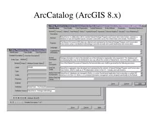
Catalog • Directory Structure • “Connected” Folders • Other data sources • Database Connections • Geocoding services • Internet servers • Search results
Contents/Preview/Metadata • Contents Tab • Preview Tab • Metadata Tab
General Use • Navigate • Data Management • Preview • View metadata
Icons indicate data directories and data type Work in Catalog or Contents Tab See Directories containing Spatial Data Drag data to other applications Navigation
Data Management • Many options for moving data • Drag and Drop • Cut and paste • Menus, buttons • Work in catalog or “Contents” • Data Conversion • Right click to see export options • Several export formats available • Option to create Layer (.lyr) file • Create New items • Folders • Spatial/Tabular data files • Geodatabases and related items
Preview • Geographic vs. Table Use the drop down menu at the bottom of the window to toggle between the geography and table views • Navigation Use the tools on the Geography toolbar to navigate around the preview window • Layers and Maps vs. Raw Data Layers and Map Document will display their symbology in the preview while Raw data is assigned default or random symbology for previews
Viewing Metadata • Types of metadata In the ESRI Style, you can click on specific items to see more detail, and there are tabs to expose different types of data(Description, Spatial, and Attribute). The other formats are more direct with the information • Metadata style Use the Stylesheet option on the metadata toolbar to change the style of display for the metadata
Advanced Use • Modifying the Interface • Modifying the Catalog • Modifying the “Contents” • Modifying Metadata • Working with Previews • Searching for Data
Modifying the Interface • Add/Remove Toolbars • Resize/Reposition Toolbars • Remove/Add Catalog • Resize/Reposition Catalog Ex.1
Modifying the Catalog • Adding Folder Connections • Connect to folder Button • File Menu • Click and Drag • Adding/Removing other top level entries • Tools>Options>General • Showing Symbols for Spatial Data • Tools>Options>General Ex.2
Modifying the “Contents” • Standard Toolbar Options • Large Icons • List • Details • Thumbnails • Tools>Options>General • Data Types • File extensions • Tools>Options>File Types • Tools>Options>Contents • Standard Columns • Metadata Columns Ex.3
Modifying Metadata • Creating and Updating metadata Metadata can be created by clicking on the Create/Update metadata button on the metadata toolbar. This will create an xml file in the same directory as the data set which will store the metadata. Upon creation, some information such as spatial extent and attribute properties will be automatically derived. Other fields must be filled in by the user. Following edits to the spatial or attribute data, click on Create/Update metadata to update the xml file. • Editing Metadata Click on the Edit Metadata button to open the metadata editor dialog. Fill in all fields marked “REQUIRED” to produce FGCD compliant metadata. • Metadata options • Tools>Options>Metadata • Automatically generate metadata • Automatically update metadata
Working with previews • Navigating Use the tools on the Geography toolbar to zoom in/out, and pan around the image. You can also identify features with the identify tool. • Making thumbnails Click on the Create Thumbnail button to make a thumbnail for a dataset. Once created, this can be displayed in the Contents window and in the metadata. • Table tools In the table preview you can click on columns, rows or cells to select them. You can also right-click on a field header to reveal basic sorting tools. Ex.4
Searching for Data • The search dialog can be opened from the Standard Toolbar as well as from the bottom of the edit menu. Several types of searches are possible: • Name and location – Basic file name search. Provide a name or part of a name and/or a directory location to look in • Geography – Provide a location either by bounding coordinates or through definition on a map and the search will return anything within or overlapping the bounds given • Date – Provide a time period and search based on data created or modified, or dates found in the metadata • Advanced – Choose a metadata field to search on. • Search results are returned to the bottom of the Catalog below the “Search Results” icon.