Download
1 / 18
180 likes | 488 Vues
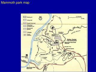
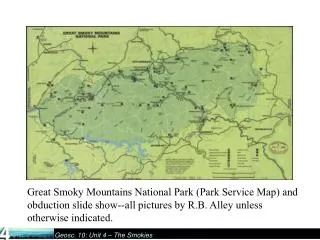
Great Smoky Mountains National Park (Park Service Map) and obduction slide show--all pictures by R.B. Alley unless otherwise indicated. .

E N D
Great Smoky Mountains National Park (Park Service Map) and obduction slide show--all pictures by R.B. Alley unless otherwise indicated.
Thunderstorm over Great Smoky Mountains National Park. The Smokies are the wettest spot in the lower-48 except for the Pacific Northwest, with the high elevations scraping rain out of the sky to water the wonderful forest.
Bridge, Great Smoky Mountains National Park. The abundant rainfall in the Smokies feeds numerous beautiful streams, such as seen here and in the next picture; many streams host native brook trout.
This photo and the next, from the USGS archives, were taken by W.B. Hamilton in 1954. They show two of the many beautiful waterfalls in the Smokies. A little extra description of waterfalls is inserted between the two.
Waterfalls usually indicate something interesting in recent geological time; water flows faster and erodes more on steeper slopes, so waterfalls quickly become rapids. Hence, these waterfalls suggest a recent event, perhaps of mountain-building. Yet, the newest scientific studies suggest that conditions have not changed recently. The debate is more than academic; if mountain-building has occurred recently, then the risk of earthquakes is higher than it otherwise would be, with implications for zoning codes and construction practices and emergency services. Although the basic outline of geology is well-known, large and important questions remain!
Another Smoky Mountain waterfall photo from the USGS archives, taken by W.B. Hamilton in 1954.
Late-autumn view, Great Smoky Mountains National Park. The ridges fading into the distance are typical of the Appalachians.
Mountain laurel, Great Smoky Mountains National Park. The ridges of the Smokies are mostly sandstones, metamorphic rocks and granites, which give rise to fairly acidic soils that are favored by rhododendron, azaleas (next pictures), and laurel, among others. Limestones in places produce less-acidic soils and host different plants.
Flame azalea, Great Smoky Mountains National Park. About 10,000 species of plants and animals are known to live in the park, and many more are probably present.
The leaves of rhododendron form the backdrop for the cascading stream in this scene from the Smokies.
Historical (1953) USGS photo by W.B. Hamilton showing old-growth forest in Great Smoky Mountains National Park.
Metamorphic rocks near Cades Cove, Great Smoky Mountains National Park. Heating caused former muds to change into new minerals, and squeezing caused the prominent folds seen. A rich and varied geological history is recorded in the diverse and beautiful rocks of the Smokies. USGS photo by W.B. Hamilton, 1953.
Folded Appalachians; caption on next page. State College Mt. Nittany Raystown Lake
The Great Smoky Mountains were raised to their present elevation by obduction, when Africa and Europe collided with North America as the proto-Atlantic Ocean closed. The whole Appalachian chain formed with the Smokies, including the Valley and Ridge Province—the folded Appalachians—in which State College, PA lies. Raystown Lake Mt. Nittany State College This autumnal NASA photograph shows State College and Mt. Nittany near the top center, as indicated. The ridges appear orange, the valleys white and blue (some of the coloration is “false-color”—NASA takes subtle differences in appearance and makes the differences appear bigger by changing the color scheme), and Lake Raystown is the black body near the center. From NASA’s Remote Sensing Tutorial.
The Great Smoky Mountains occupy the lower-right part of this image, with the folded Appalachians across the center and the Cumberland Plateau in the upper left. The false-color image is from the NASA Remote Sensing Tutorial.
Obduction, which produced the Great Smokies, the folded Appalachians, the Himalaya, etc., has some things in common with running a car into a brick wall or another car. Something long and thin becomes short and thick, with folds and push-together faults. This rather elegant example is from crash-safety testing by the Department of Transportation, Transportation Statistics Annual Report 2000.