Download

1 / 32
320 likes | 544 Vues
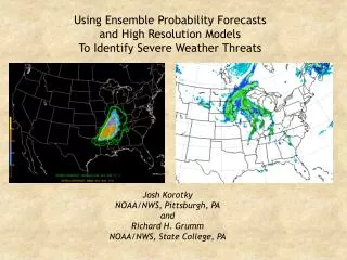
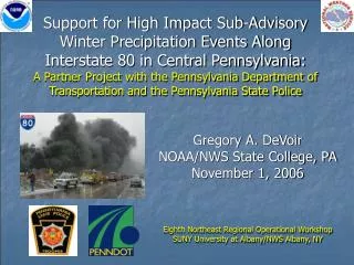
Support for High Impact Sub-Advisory Winter Precipitation Events Along Interstate 80 in Central Pennsylvania: A Partner Project with the Pennsylvania Department of Transportation and the Pennsylvania State Police. Gregory A. DeVoir NOAA/NWS State College, PA David Ondrejik

E N D
Support for High Impact Sub-Advisory Winter Precipitation Events Along Interstate 80 in Central Pennsylvania:A Partner Project with the Pennsylvania Department of Transportation and the Pennsylvania State Police Gregory A. DeVoir NOAA/NWS State College, PA David Ondrejik NOAA/NWS State College, PA
References • Colby, F. P., Jr. and B. Krajewski, 2005: Forecasting Snow Squalls Using Mesoscale Models. 21st Conference on Weather Analysis and Forecasting, Washington, D.C., Amer. Meteor. Soc. • DeVoir, G.A., 2004: High impact sub-advisory snow events: The need to effectively communicate the threat of short duration high intensity snowfall. 20th Conf. Wea. Forecasting, Seattle, WA, Amer. Meteor. Soc. • Eisenberg, Daniel, 2004: The Mixed Effects of Precipitation on Traffic Crashes, University of California Berkeley. • Fridstrom, L., Liver, J., Ingebrigtsen, S., Kulmala, R., Thomsen, L., 1995. Measuring the contribution of randomness, exposure, weather, and daylight to the variation in road accident counts. Crash Anal. Prev. 27 (1), 1–20.
What is Impact? • How do we assess it? • Can we quantify or verify it? • Impact is dynamic and depends on any number of constantly changing variables • We may not be able to quantify it, but we all know significant impact when we see it (and so does the media)
High Impact Sub-Advisory (HISA) Snowfall • Short duration, high intensity snow (falling in bursts or squalls) with 1-3” amounts in a 1 to 2 hour period, greatly magnifies impact • Instantaneous whiteouts, rapidly changing road conditions and driver anxiety/confusion make chain reaction accidents more likely • The terms “high impact” and “sub-advisory” (HISA) are used here to describe such events
The HISA Problem • On average, throughout the winter months, sub-advisory snowfalls occur 3 to 4 times as often as Snow Advisory and Warning events • When sub-advisory snow impact is high (intensity and timing), information dissemination becomes crucial. • How do we get this information to the people who need it most? • How can we mitigate the potential impact if people don’t receive the information?
The HISA Problem • Predictability • Localized events • Sometimes, but not always predictable more than a few hours in advance • Analogous to severe local convection • “Conditions are favorable for the formation…” • Imminent threats require short fused dissemination and immediate response
Recent High Impact Sub-Advisory Events in PA • 22 February 2001 – 2 to 3 inches of snow in less than 2 hours throughout central and northern mid-Atlantic states • Numerous chain reaction accidents - 300 vehicle pileup north of Washington D.C. • 28 December 2001 - Lake Effect Snow Squall (Loganton, PA) • 8 Dead • 5 January 2003 – 1 to 3 inches of snow in less than 3 hours across south central PA (midday Sunday - church services)
Arctic Fronts w/Squalls FLASH FREEZE Plunging Post-frontal Sub-freezing Temperatures Above-freezing prefrontal temperatures
Lake Effect Snow Showers and Squalls © geology.com
NOAA Strategic Plan andthe NWS Mission • “Support the Nation’s commerce with information for safe, efficient, and environmentally sound transportation” • NWS Data and services protect life and property, an inherently governmental function, with direct benefit to the national economy
Early Work: NWS State College, PAWinter 2003-2004 • Focus on I-80 and on the most susceptible counties in our CWA • Provide immediate notifications via: • Judicial SPS issuances with pathcasts and detailed impact statements • Phone calls to individual county PENNDoT and PSP offices
Early Work 2003-2004 • PENNDoT • Intelligent Transportation Systems (ITS) • Highway Advisory Radio • Dynamic Roadside Signs • $$$ and Limited availability/deployment
January 6, 2004 Milesburg, PA CDT PHOTO/MICHELLE KLEIN AP PHOTO CDT PHOTO/MICHELLE KLEIN CDT PHOTO/NIKI DESAUTELS CDT PHOTO/NIKI DESAUTELS Photo Credits: Centre Daily Times (CDT) and AP
January 6, 2004 • A total of 6 dead • A total of 17 injured - Life Flight evacuations • 20 Tractor Trailers and 17 Automobiles involved • Multi-million dollars in damage (estimate not available) • Support from 7 counties, 80 agencies, and over 700 first responders • Response and recovery - 30,0000+ man hours. • Outstanding lawsuits – years of litigation
I-80 Notification Plan • Two tiered approach • Long term: • Email notifications (1-2 days in advance) sent to all county PENNDoT and PSP contact points • Short term: • Highly detailed SPSs (issued not only for I-80 area) • Phone Call Chain • 1 phone call originates from WFO State College • PENNDoT Activation of ITS highway signs and Highway Advisory Radio • PSP Support – cruisers dispatched to edge of affected area to run lights, slowing traffic
PAZ012-018-019-045-049-230045-NORTHERN CENTRE-NORTHERN CLINTON-SOUTHERN CENTRE-SOUTHERN CLINTON-UNION-749 PM EDT FRI SEP 22 2006 • ...A SNOW SQUALL WILL AFFECT UNION...CENTRE AND CLINTON COUNTIES...AT 748 PM EDT...NATIONAL WEATHER SERVICE DOPPLER RADAR INDICATED A SNOW SQUALL 12 MILES NORTH OF BELLEFONTE...MOVING EAST AT 30 MPH. THE SQUALL WILL BE NEAR BALD EAGLE STATE PARK...HOWARD AROUND 755 PM...BEECH CREEK AROUND 800 PM...LAMAR...MILL HALL...LOCK HAVEN AROUND 810 PM...MACKEYVILLE...REBERSBURG AROUND 815 PM...LOGANTON AROUND 830 PM AND CARROLL AROUND 835 PM. • THIS WILL IMPACT THE FOLLOWING CENTRAL PENNSYLVANIA INTERSTATES...I-80 BETWEEN MILE MARKERS 165 AND 199.THIS WILL ALSO IMPACT THE FOLLOWING MAJOR ROADS...ROUTE 220...STATE ROAD 45. • THE SNOW WILL RAPIDLY DROP VISIBILITIES IN THE SQUALL TO NEAR ZERO.USE EXTREME CAUTION IF YOU MUST TRAVEL INTO OR THROUGH THISPOTENTIALLY DANGEROUS SNOW SQUALL. CONSIDER DELAYING TRAVEL UNTIL THESQUALL PASSES YOUR LOCATION. • $$
Ongoing Work • Expanding notifications beyond I-80 • I-80 work is experimental, labor intensive: Cannot be duplicated CWA-wide due to workload • Coordinate future notifications through Emergency Management (PEMA, EMAs) • Expand and fully automate notifications for all major highways: Statement of Need (SON) for a new NWS Warning Product with EAS
February 10, 2008 • Hazleton, PA: I-81* • 68-vehicle pileup • 1 dead, dozens injured • Snow squall ahead of arctic front • Rochester, NY: I-390* • 36-car chain reaction accident • 1 dead, 24 injured • post-frontal white out conditions *Outside of Experimental I-80 Partner Project Area
Statement of Need (SON)Snow Squall Warning • Co-authored by NWS Binghamton, NY and State College, PA through NWS ER HQ • Needs: • A new AWIPS product ID with a new WMO header: SSWxxx (where xxx is the WFO id) • A new VTEC code, SS.W • New EAS code SSW (could use the WSW code in the interim) • Criteria for issuing the warning • Verification • Training • Customer education and outreach
Statement of Need (SON)Snow Squall Warning • Benefits and Performance Impact • Performance Measure Impacts: • Would not address a GPRA goal specifically, but could be worked into winter weather warnings. • Socio-Economic Impacts: • Enormous: Alert road crews, the public, police, fire and emergency management • Feed into highway warning systems (ITS), pagers, cell phones, radio stations to raise awareness • Mitigative actions may prevent or reduce the severity of crashes, reducing loss of life and property, and disruption to commerce
Statement of Need (SON)Snow Squall Warning • Key Customers and Stakeholders • Customers: • The general public, transportation industries, state, local and county government. Stakeholders: • Stakeholders: • Emergency management, department of transportations, police, fire and other first responders.
New Warning Has Support from General Public • Unsolicited email to NWS HQ from general public in support of winter weather warning for high impact snow squall events nick.kovatch@valpo.edu subject: From Weather.gov comments: To whom it may concern, My name is Nick Kovatch and I am a television/radio major at Valparaiso University. I have grown up in Northern ndiana all my life and I am accustomed to all the wild winter weather that affects us here, including lake-effect snow. As a weather enthusiast, I was browsing a message board and an interesting topic was brought to my attention. The NWS should create a warning for extremely heavy squalls of lake effect snow. This warning shouldn't be just a Lake-Effect Snow Warning, but a warning that would be treated like a Tornado, Severe Thunderstorm, or Flash Flood Warning. Something that would turn on weather radios and be put on local television” The criteria would be for an event like we saw last Wednesday that caused the accidents on I-94. I'm sure that if people had a more influential warning, the accident could have been minimized. I was going to Valpo from home on ednesday, and didn't realize how bad the squall was until I hit Porter County. I had no warning whatsoever. Something like a "White Out Warning" or a "Heavy Snow Squall Warning" would get the publics attention. Just a thought that could possibly save many lives. I hope you consider it and I'd be happy to work with you more on it. Thanks.
New Warning Has Support from Media Partners • Email from media in support of Proposed Winter Weather Simplification, and also a short-fused winter weather warning for snow squall events. “That is why I would propose to you the idea of a product similar to a Severe Thunderstorm Warning, but for winter-time purposes; something like a Snow Squall Warning….I would propose creating it similar to SVRs or TORs, so that media crawl systems, automated web site displays and most importantly EAS can be activated.” Matt Lanza Meteorologist WKTV - Utica, NY
Additional Ongoing Work • Find event “fingerprints” • Ensembles • Past event reconstructions with mesoscale models • Classify events • WAF or BAMS article
Final points • “Accidents will happen” • However, timely and efficient notification allow DOT and State Police to mitigate HISA snow impacts • A new Snow Squall Warning would streamline this • High Impact Notifications • Reduce the severity of accidents • Save lives, reduce injuries • Decrease property damage
Acknowledgements • David Ondrejik: WCM, WFO State College PA • Laid groundwork with PENNDOT and PSP to develop I-80 notification plan • Facilitated implementation/support to WFO operations • David Nicosia: WCM, WFO Binghamton NY • Statement of Need (SON) co-author for creation of Snow Squall Warning (SSW)
Acknowledgements • WFO State College, PA Operational Staff • Swiftly adopted I-80 notification plan into operations • Provided important proof-of-concept to expand notifications regionally – and for possible creation of a new winter warning product • NWS Eastern Region HQ • Support and leadership to move forward