Download
1 / 23
230 likes | 531 Vues
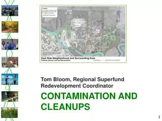
Assessing and Communicating Risk: A Partnership to Evaluate a Superfund Site on Leech Lake Tribal Lands. Groundwater Movement and Contamination. By Cindy Hagley Minnesota Sea Grant March 2003. Groundwater Basics.

E N D
Assessing and Communicating Risk:A Partnership to Evaluate a Superfund Site on Leech Lake Tribal Lands Groundwater Movement and Contamination By Cindy Hagley Minnesota Sea Grant March 2003
Groundwater Basics • Groundwater occurs almost everywhere within the pore spaces of saturated rock beneath the land surface. • Groundwater is not like an underground river or lake. In fact, groundwater is more like the water in a sponge, held within the tiny pores. Direction of groundwater movement
Ground versus Surface Water Movement • The rate of groundwater flow is very slow compared to surface water. • Typical groundwater flow rates range from several inches to feet per year. sw GW
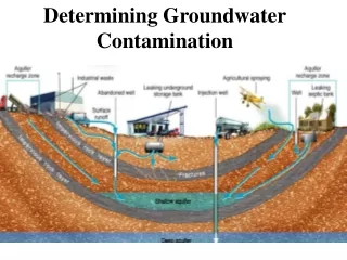
Aquifers • Aquifers are water-bearing layers of rock or sediment that contain usable quantities of water. • Aquifers are made up of loose materials such as sands and gravel, or bedrock, such as sandstone or fractured granite.
Surface Aquifer • Unconfined – interacts with surface water • Influenced by gravity and flows from higher to lower groundwater elevations, much like river water. • The steeper the slope of the groundwater “table,” the faster the groundwater will flow.
Confined Aquifer • Pressure, rather than gravity, makes water move in confined aquifers. Water moves from areas of high to low pressure. • Confining layer – clay or bedrock Confining layer
How Wells Influence Groundwater Flow • Pumping wells create a cone of depression. • Water flows toward the cone of depression. • The area affected by the well is called the area of influence.
Pumping Water from Wells • Pumping water from aquifers can lower groundwater levels. • Pumping changes groundwater flow patterns. • For example, water used to flow from groundwater to lake. Now flowing from lake to groundwater. • Could lead to change in groundwater quality.
How Does Pumping Water from Wells Influence Water Quality? • Pumping water from a well draws the water table down and can pull in contaminants from the well’s area of influence.
clay confined aquifer Groundwater Susceptibility Things to keep in mind: • Unconfined aquifers with no cover of dense material are susceptible to contamination. • Bedrock with large fractures is susceptible, because the fractures provide pathways for contaminants. • Confined, deep aquifers tend to be better protected than surface aquifers with a dense layer of clay material. • Wells that connect two aquifers increase the chance of cross contamination between the aquifers.
Treating Facility Site Channel Pump Out Wells Containment Vault Fish Hatchery City Dump Pike Bay Fox Creek
Upper Aquifer Confining Layer Lower Aquifer Toward Cass Lake and Pike Bay
Treating Facility Site Channel Pump Out Wells Containment Vault Fish Hatchery City Dump Pike Bay Fox Creek Company data from wells suggests west to east flow Company analytical model suggests NW to SE flow
Pump out wells are to the east of the site Treating Facility Site Channel Pump Out Wells There are no sampling wells to the SE of the site, so we don’t know if contaminants are moving in that direction Containment Vault Fish Hatchery City Dump Pike Bay Fox Creek Data from wells suggests west to east flow Analytical model suggests NW to SE flow
LNAPLs – Light non-aqueous phase liquids Pump Out Well Toward Cass Lake and Pike Bay Translation- Floating plumes of contaminants that don’t mix with water
Pump Out Well Toward Cass Lake and Pike Bay DNAPLs – Dense non-aqueous phase liquids Translation - Sinking plumes of contaminants that don’t mix with water Confining Layer
Pump Out Well DNAPLs ? ? ? ? ? Toward Cass Lake and Pike Bay
50 feet • Uneven surface of confining layer (variations of ~5 feet in height) Ground-penetrating radar survey (H. Mooers and N. Wattrus – University of MN Duluth) • DNAPLS could be pooling at base of surface aquifer
Groundwater Panel Conclusions • The confining layer is not continuous and may hold pools of dense contaminants that could be removed. • There is a risk that contaminants from the surface aquifer could be reaching the deep aquifer. • Evidence suggests that the pump-out wells may not be extracting all contaminants – some data suggest that a contaminant plume is moving off-site toward Cass Lake/Pike Bay.
Groundwater Panel Conclusions • There are not enough wells, particularly to the southeast of the site, to properly assess the extent and movement of contaminants. • Our understanding of the site’s geological character is very poor.
Recommendation • The site must be better characterized to understand the movement of contaminants – • additional groundwater wells to the southeast • more comprehensive analytical model of the site • additional techniques to better characterize the site, such as Ground Penetrating Radar • better data quality.
Treating Facility Site Channel Pump Out Wells Containment Vault Fish Hatchery City Dump Pike Bay Fox Creek