Download
1 / 1
90 likes | 381 Vues
Environmental Impact Assessment: A Land Use Planning Tool. Diane Sherman, Ben Purdy, and Sara Felker Department of Resource Development. Introduction

E N D
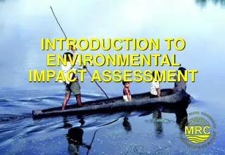
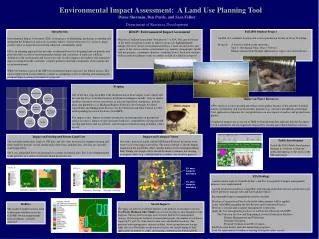
Environmental Impact Assessment: A Land Use Planning Tool Diane Sherman, Ben Purdy, and Sara Felker Department of Resource Development Introduction Environmental Impact Assessment (EIA) is the process of identifying, predicting, evaluating and mitigating the biophysical and socio-economic effects of proposed actions (i.e. projects, plans, policies) prior to major decisions being taken and commitments made. EIA is an planning approach that provides an informed basis for designing land use policies and plans that take account of environmental potentials and constraints. It embraces a holistic definition of the environment and focuses not only on direct impacts but indirect and cumulative impacts arising from the sometimes complex pathways that link components of the natural and social environment. While best known as part of the NEPA environmental approval process for federal actions, EIA can be employed in a non-regulatory context as a planning tool for evaluating and managing the potential impacts arising from land use proposals. RD415: Environmental Impact Assessment Objectives: Students learn about “best practice” in EIA. The course focuses on the multi-disciplinary nature of land use proposals, highlighting the linkages between various environmental media (i.e. land, air and water) and aspects of the socio-economic environment (e.g. amenity, demography, health, land use patterns, community character, economic flows). Each year students work in multi-disciplinary teams to conduct an EIA of a land use proposal. Fall 2001 Student Project An EIA of 4 candidate locations for a swine production facility in Vevay Township. Proposal: A farrow to finish swine operation; Year 1: 460 Animal Units; Year 5: 920 A.U. Manure management through application to crops (corn and soybeans). Scoping One of the first steps in an EIA is the identification of those impact issues which will become the focus of detailed analysis. Evaluation techniques include: visits to similar facilities; literature review; and review of relevant legislation, regulations, policies, plans and guidelines (e.g. Michigan Right to Farm Act; the Generally Accepted Agricultural and Management Practices for Site Selection and Odor Control for New and Expanding Livestock Facilities (GAAMPS). Key impact issues: Impact of manure production and management on ground and surface resources; impact of odor on nearby land uses; compatibility of proposal with existing and future land use patterns; and the impact of land clearing on habitat values on-site. Impact on Water Resources AFOs can pose a risk to ground and surface water quality because of the amount of animal manure and nutrient rich wastewater they generate (e.g., nitrogen, phosphorus, potassium). Over application of manure for crop production can also impact on surface and ground water quality. Cumulative impacts are a concern as DEQ well monitoring data indicates that the Sycamore Creek watershed is already negatively impacted by existing agricultural land use activities. (Rallus elegans) Impact on Existing and Future Land Uses The township master plan, land use GIS data, and site visits were used to examine existing and future land use patterns on and around each of the four candidate sites. All sites are currently zoned agriculture. Site 4 was eliminated due to its proximity to a future residential area. Site 2 was eliminated due to the presence of a series of wetlands which dissect the site. Impact on Ecological Values Site visits, historical aerials and the MI Natural Features Inventory were used to assess the impact on habitat. The natural habitat is already highly fragmented but potentially offers suitable habitat for the endangered King Rail. During site design, efforts should be made to enhance the existing ecological values (e.g. establish habitat corridors; use of native grasses). Public Involvement Part of the EIA’s Public Involvement Strategy is a website to keep the public informed as to the status of the EIA and project. 5% odor footprint boundary • EIA Findings • A multi-criteria analysis found both Site 1 and Site 3 acceptable if impact management measures were implemented. • A swine production facility is compatible with existing and future land use patterns but care will be needed to manage odor and water quality effects. • Recommended impact management measures include: • Develop a Conservation Plan for the fields where manure will be applied. • Liaise with MDA regarding the Site Review and Verification Process. • Develop a site plan and a manure management system plan. • Apply the best management practices set forth in the following GAAMPS: • Site Selection for New and Expanding Livestock Production Facilities. • Manure Management and Utilization. • Nutrient Utilization. • Pesticide Utilization and Pest Control. • Establish water quality and odor monitoring programs. • Look for opportunities to enhance existing ecological values on-site. 1% odor footprint boundary Social Impacts The impact of odor on residential amenity is the primary social impact concern. The Person Michigan Odor Model was used to develop an odor footprint for the proposal. Various facility designs were tested to find the best management strategy. Overlaying the footprint on aerial photographs, the number of residences impacted 5% and 1% of the time by odor was calculated for each site. The preferred odor management strategy includes: above ground manure storage tanks, the use of bio-filters on the nursery facility; the careful timing of land applications of manure to crops; and ongoing communication with neighbors. Buffers The ArcView buffer tool was used to determine whether or not the GAAMP setback requirements from residences could be achieved.