Download
1 / 17
170 likes | 336 Vues
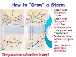
How to “Grow” a Storm. Upper level shortwave passes Upper level divergence -> sfc low Cold advection throughout lower troposphere Cold advection intensifies upper low Leads to more upper level divergence. Temperature advection is key!. Fronts.

E N D
How to “Grow” a Storm • Upper level shortwave passes • Upper level divergence-> sfc low • Cold advection throughout lower troposphere • Cold advection intensifies upper low • Leads to more upper level divergence Temperature advection is key!
Fronts AFront - is the boundary between air masses; normally refers to where this interface intersects the ground (in all cases except stationary fronts, the symbols are placed pointing to the direction of movement of the interface (front) Warm Front Cold Front Stationary Front Occluded Front
Characteristics of Fronts • Across the front - look for one or more of the following: • Change of Temperature • Change of Moisture • Change of Wind Direction • Change in direction of Pressure Gradient • Characteristic Precipitation Patterns
How do we decide what kind of front it is? • If warm air replaces colder air, the front is a warm front • If cold air replaces warmer air, the front is a cold front • If the front does not move, it is a stationary front • Occluded fronts do not intersect the ground; the interface between the air masses is aloft
Stationary front Open wave Incipient cyclone dissipating occlusion Mature stage Lifecycle of a Midlatitude Cyclone Green shading indicates precipitation Takes several days to a week, and moves 1000’s of km during lifecycle
What maintains the surface low? Imagine a surface low forming directly below upper level low Surface convergence “fills in” the low Surface divergence “undermines” the high
Actual vertical structure Upper level low is tilted westward with height with respect to the surface. UPPER LEVEL DIVERGENCE INITIATES AND MAINTAINS A SURFACE LOW.
Cold Front Structure • Cold air replaces warm; leading edge is steeper due to friction at the ground • Strong vertical motion and unstable air forms cumule clouds (thunderstorms!) • Upper level winds blow ice crystals downwind creating cirrus and cirrostratus
Warm Front Structure • In an advancing warm front, warm air rides up over colder air at the surface; slope is not usually very steep • Lifting of the warm air produces stratus clouds and precipitation well in advance of boundary • At different points along the warm/cold air interface, the precipitation will experience different temperature histories as it falls to the ground
Summary of Cyclone Weather Roles of convergence and divergence aloft Pattern of clouds, precipitation, and temperatures on the ground
“Conveyor Belts” This model describes rising and sinking air along three “conveyor belts” A warm conveyor belt rises with water vapor above the cold conveyor belt which also rises and turns. Finally the dry conveyor belt descends bringing clearer weather behind the storm.
Follow the Energy! • Midlatitude storms release gravitational potential energy arising from the temperature differences found in the different air masses north and south of the polar front • Cold, dense air pushes warmer, less dense air up and out of the way • “Up warm, down cold” • These storms let the atmosphere lower its center of mass … “air falling down”
Lifecycle of a Midlatitude Cyclone • Pressure surfaces tilt because of N-S temperature contrast • Passing wave initiates divergence and cyclonic vorticity • Cold air undercuts warm, and flows south • Cold air advection undermines upper trough, deepening it • N-S mixing in cyclone eventually consumes the available potential energy, and cyclone dies
The “Big Picture” • We’ve emphasized horizontal transport of energy to balance the planetary energy budget: • Hadley Cell • Subtropical divergence • Midlatitude cyclones and conveyor belts • What about vertical motion? • “Up-warm, down cold” • “Up moist, down-dry” • Severe weather is all about vertical motion, and represents local release of energy that contributes to planetary energy balance