Download
1 / 32
330 likes | 495 Vues
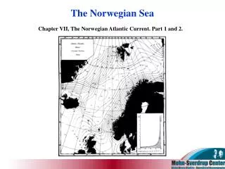
The Norwegian Sea. Chapter VII, The Norwegian Atlantic Current. Part 1 and 2. 1. Course and Extent of the Current. Entrances of atlantic water to The Norwegian Sea NAC Irminger Current Depth of the entrances Volume transports and distribution of temperature and salinity.

E N D
The Norwegian Sea Chapter VII, The Norwegian Atlantic Current. Part 1 and 2.
1. Course and Extent of the Current. • Entrances of atlantic water to The Norwegian Sea • NAC • Irminger Current • Depth of the entrances • Volume transports and distribution of temperature and salinity
1. Course and Extent of the Current. • The area between the Faeroes and Iceland - characteristics • Equilines close to the Faeroe-Iceland ridge. Differences in salinity, temperature and density. • The slope of the equilines of the sections. • Bight / tongue 63o– 64o N, 10o– 12o W. • Vortex west of the bight. • Eastward current north of the Faeroes. • Northeast of the Faeroes the current bends and turn south/southeast, as opposed to the suggestion of Nielsen (1904).
1. Course and Extent of the Current. Fig. 39. Horizontal Distribution of Salinity at 100 Metres, May . 1904. The arrows indicate the probable movement of the waters at this level.
1. Course and Extent of the Current. Stations. Mai-June 1904
1. Course and Extent of the Current. Section north of the Faeroes, directed north. (May-June, 1904)
1. Course and Extent of the Current. Section further west
1. Course and Extent of the Current. 400 m 500 m Section futher west, directed northeast, crossing the bight.
1. Course and Extent of the Current. Salinity and temperature Equilines at 400 m.
1. Course and Extent of the Current. Section northeast of the Faeroes, directed mainly to the east
1. Course and Extent of the Current. • The Faeroe-Shetland Channel - characteristics • Main entrance of Atlantic Water to The Norwegian Sea. • Atlantic water coming from northeast of the Faeroes. • Concentration of the Atlantic Current. Sometimes vortices. • Significant, rapid changes in the conditions of the channel, even at large depths (ex. bottom water in the southern part of the channel: August 1903. Salinity of 35.03 ‰, temperature 1.7o C, instead of 34.92 ‰, temperature –1o C.
1. Course and Extent of the Current. • Offshoots to the north sea. • South/southeast bend of the isolines northeast of Shetland • Robertson (1905, 1907): Main entrance Shetland-Orkneys. HH & N disagrees, refer a. o. to salinity. • Continuous flow of very salty water towards Scottish waters on the east side. (Subject to seasonal and yearly variations.) • HH (1902, 1904, 1905a): NAW forms bottom water in the North Sea. • Some NAW enters the Norwegian Channel, continuing south-east in the deeper strata
1. Course and Extent of the Current. Salinity and temperature Equilines at the surface.
1. Course and Extent of the Current. • The Norwegian Sea • Deflection due to the earth’s rotation. • Vortices: Northeast of Shetland (62º N), off Sunmøre (63º N – 64º N) and off Lofoten (67º N – 68º N). • Division of the current off Sunmøre: 1) Eastern part . 2) Western part. • Cyclon in the southern part of the Norwegian Sea. • AW in subsea fjords at the Norwegian shelf. • General northward decrease of salinity.
1. Course and Extent of the Current. Salinity and temperature Equilines at 50 m off the west-coast of Northern/Western Norway. (July-September, 1900.)
1. Course and Extent of the Current. • Mixing with other water masses • Baltic Current (Norwegian Coastal Current) from the east • Central Water from the west • Arctic Water Masses (from The East Iceland Current) from the west • Sinking of the 35‰ isohaline up north. • Conclusion about vortices? • Variation of NAC’s depth due to oscillations
1. Course and Extent of the Current. • Out and inflow of NAW in The Norwegian Sea. • Norwegian Sea and adjecant seas almost an enclosed area with one main entrance/exit. • Evaporation/precipitation. Water running in must again run out. Amount of salt carried in and out? • Three principal openings where water is carried out of the Norwegian sea-basin.(1) Norway-Bear Island(2) Spitsbergen-Greenland(3) Iceland-Greenland • Faeroes-Iceland • Salinity of the outgoing currents? Conclusion? • After mixing with AW, small part of the NAW -> western region of Cyclone in the southern part of the Norwegian Sea -> East Greenland Polar Current
1. Course and Extent of the Current. • Southern area of the Norwegian sea and transports. • Between Jan Mayen and Iceland: Net inflow (EIAC in and some mixed NAW out) • From the south: NAC & Baltic (Norwegian Coastal) Current. • Conclusion: At least as much water passing through the section Jan Mayen – Vesteraalen as that passing the Faeroes-Shetland ridge. • Northen part. • NAC changed up to the North of Norway, less saline waters => mixing in the interior. • Between st. 66 & 65 (September, 1900): Dramatic change. Much more water with salinity > 35.1 ‰ to the south of st. 66 than further north. Why? (Split, and also possible vortex.)
1. Course and Extent of the Current. Longitudinal section running southwards from a point west of Bear Island. (September, 1900.)
1. Course and Extent of the Current. • The quantity of (diluted) NAW water in the SAC and the NCC is less than the quantity of NAW comming in. => Conclusion? • Westward movement of NAW(1) To a small extent: Between Jan Mayen and Iceland(2) North of the latter. NAW off Spitsbergen / North Cape. => Cyclonic system in the northern part of The Norwegian Sea. Some part => EGPC. • Intermediate warm water under the EGPC: Thicker layer between Jan Mayen and Greenland, but most of this is assumed to come from the north.
1. Course and Extent of the Current. Horizontal Distribution of Temperature and Salinity in the Northern Norwegian Sea in the Summer, according to observations made in different Years. The lighter shading indicates salinity from 34.90 to 35.00 ‰ , darker shading above 35.00 ‰.
2. The Velocities of the Current and the volumes of Water Conveyed by it. • Direct current-measurements in the Norwegian Sea till that time • HH with Michael Sars July 1906. • Measurements at Storeggen (average current over 25h):(1) Max speed of 25 cm/s close to the surface (NCC).(2) Min speed of 10-11 cm/s at 70m depth, interface between NCC and NAC.(3) Speed in deeper strata had an intermediate maximum of 14 cm/s.(4) Considerable variations of speed, also in the deeper strata (5.8 – 28 cm/s)(!)(5) Direction of velocity. • Calculations of the velocity • Geostrophic method • Problems:(1) Assumptions(2) Average values / resolution
2. The Velocities of the Current and the volumes of Water Conveyed by it. Dynamical Section seawards from Stad, June, 1904.
2. The Velocities of the Current and the volumes of Water Conveyed by it. Dynamical Chart for the upper 200 Metres,. May-June.1904 .
2. The Velocities of the Current and the volumes of Water Conveyed by it. • Surface velocities of the current in the eastern part of the Faeroe-Shetland Channel (Helland-Hansen, 1905a, b; Robertson, 1905, 1907)
2. The Velocities of the Current and the volumes of Water Conveyed by it. Fig. 47. Section seawards from Stad, June, 1904. giving the differences, in cm. per second. between the velocity-components at the surface and at the various depths down to 600 metres. The dotted lines are the isopyknals of 27.50- 28.00.
2. The Velocities of the Current and the volumes of Water Conveyed by it. • The whole section of the Atlantic current, Sunnmøre: • Stad (st. 39 - 68, June 1904): (1) At least 7 cm/s to the northeast (assumption about waters at 500 m). (2) Fresh surface water. (3) Atlantic water at 100 m: 5.5 cm/s.(4) 3 - 400 m: 2 - 3 cm/s. • Stad (similar section, June 1903):(1) The part of the current closest to the contintal slope (st. 32-33): 5.3 cm/s(2) The section as a whole: 5.1 cm/s(3) The whole section almost identical to the 1904 section with every secondstation taken out. Conclusion? Possible explanation? • Mean differences of the velocity components of the whole section (slightly) larger for 1904 than for 1903. Possible explanation?
2. The Velocities of the Current and the volumes of Water Conveyed by it. Section seawards from Stad, June, 1903..
2. The Velocities of the Current and the volumes of Water Conveyed by it. • Ålesund section, November 1903:(1) Maximum velocity further seawards than usual. 13.1 cm/s surface relative to 400 m depth.(2) For the whole section: Velocities as in the 1903 Stad section, slightly larger, and agree well with the differences of NAW in the 1904 Stad section. • Conclusion of these measurements: Surface current off the contiental slope west of Sunnmøre of 6 - 10 cm/s. Near the slope: Larger velocities, up to more than 20 cm/s.
2. The Velocities of the Current and the volumes of Water Conveyed by it. • The whole section of the Atlantic current, Northern Norway • Helgeland section (June, 1903 and 1904):(1) No indications of vortices.(2) Maximum velocity located as usual. • Lofoten section (May, 1904):(1) Clear indications of vortices.(2) Mean differences near the continental slope seemingly smaller in magnitude than further south. (3) Average surface velocity of the whole section: ~ few centimeters per second.(4) In many parts, still larger magnitudes (ex. western boundary of NAC). • Vesterålen section (February, 1901) (stormy weather at sample time):(1) Surface current of at least 35 cm/s.
2. The Velocities of the Current and the volumes of Water Conveyed by it. Section seawards from Vesterålen, February, 1901.
2. The Velocities of the Current and the volumes of Water Conveyed by it. • Volume transports: • HH (1905a, b): Northward volume transport of AC through the Faroe-Shetland Channel: About 4 Sv. • May & June 1904, Faeroe-Shetland Channel: 4.5 Sv • Stad Section: 3.8 Sv (largest transport between st. 38 and 39) • Lofoten Section, seawards to st. 20A, upper 500 m: 2.3 Sv. • Slightly larger transports in 1903 for Stad and Lofoten. • Main conclusion: • ~ 4 – 5 Sv of NAW through the Faeroe-Shetland Channel,~ 2 – 3 Sv passing the 67th parallell of Latitude. • AC ~ 30 yrs to fill the Norwegian Sea Basin. Even so, large masses of NAW.