Urban Land Use Models
Urban Land Use Models. 3 - Urban Land Use Models. Simplified graphic summaries of large urban centres in the USA. Used to describe the structure of the central city areas.

Urban Land Use Models
E N D
Presentation Transcript
3 - Urban Land Use Models • Simplified graphic summaries of large urban centres in the USA. • Used to describe the structure of the central city areas. • Economic and technological advances have superseded the usefulness of these models but they still describe the basic physical structure of a city.
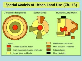
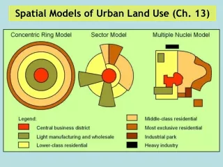
Urban land use models • Common starting point is the CBD. • Models differ in how they explain the location and development of the city outside of the CBD. • Three main types of models: Concentric zone model (Burgess 1920’s) Sector model (Hoyt 1930’s) Multiple-nuclei model (Harris and Ullman 1940’s)
Concentric zone model • Views the urban area as a set of four nested rings: • 1 – transition zone: deterioration of old residential area, now high-density, low-income ghettos. • 2 – zone of “working people” residential area (older homes on small lots. • 3 – single-family house zone: population wealthy enough to afford housing choice, and able to commute. • 4 – commuter zone: low-density suburbs.
Burgess’s Concentric Model CBD Central Business District
Burgess’s Concentric Model CBD Central Business District Inner City
Burgess’s Concentric Model CBD Central Business District Inner City Inner Suburbs
Burgess’s Concentric Model CBD Central Business District Inner City Inner Suburbs Outer Suburbs
Burgess’s Concentric Model CBD Outer Suburbs Inner City Inner Suburbs
Modeling Cities: Burgess 1 CBD - businesses, highest land value2 Transition Zone - poorest people, blue collar used to live here3 Independent Workers - apartments, blue collar workers (walk to work)4 White Collar Homes - horse and buggy, streetcars5 Commuters - no daily contact (lettuce farmers); latertrains allow many
Concentric zone model • In Chicago, Burgess’s home town, the great fire of 1871 leveled the core • The result of rebuilding was a more explicit social patterning • Chicago became a segregated city with a concentric pattern • This was the city Burgess used for his model • The actual map of the residential area does not exactly match his simplified concentric zones
What is the Hoyt sector model? • Hoyt proposed the idea that towns grew as sectors or wedges. • Industry grew up in one part of a 19th century town, future industries would then develop in that sector. • As the town grew, so would the area of industry and therefore would grow out in a wedge shape.
A –The Central Business District (CBD) • This area contains shops, offices, banks, etc. • Land is expensive, and this area has high rents and multi storey buildings as a consequence. • There is very little space and competition is high. • Congestion levels are high. • Vegetated areas are sparse.
B1- Zone of Transition (Twilight zone) • This contains old industries that have been positioned in this zone for many years. • Over the past 20 years, this industry has been non-profitable and has closed. • This has led to high-unemployment. • This area should be re-developed into modern business districts.
B2- Low class residential housing • This group is made up of old 19th century buildings. With no gardens. • Often referred to as ‘slums’. These were the buildings that were knocked down in the 1960’s to be replaced with high rise flats. • The poorest people in the settlement live here, but is now highly admired and the place to live now (due to gentrification).
C- Council Estates • Semi-detached housing is found here with no gardens. • These houses are built on large estates. • Less expensive private estates can also be found here. • Often described as ‘medium class residential’ or ‘inter-war’ areas.
D- Commuter zone • This is a high class residential area where private, quality housing can be found. • Detached and semi-detached housing can be built on cheaper land. • Often lots of garages, big gardens, and many out buildings can be found here. • Most people commute to work from this zone as it is furthest away from the centre.
E- Countryside Areas • In the countryside surrounding the urban area, those seeking to escape from the urban area can live in pleasant surroundings. • However, they are still close to work. • Many satellite villages and towns surround major urban areas allowing people to live further away from the main settlement.
Modeling Cities: Hoyt Stresses the importance of transportation corridors. Sees growth of various urban activities as expanding along roads, rivers, or train routes.
Multiple-nuclei model • Large cities develop by the spread from several nodes, not just the one CBD. • Individual nodes with specific functions (industrial, commercial, residential) developed originally due to benefits from clustering next to similar activities
Multiple nuclei model • The model has four geographic principles • Certain activities require highly specialised facilities • Accessible transportation for a factory • Large areas of open land for a housing tract • Certain activities cluster because they profit from mutual association • Certain activities repel each other and will not be found in the same area • Certain activities could not make a profit if they paid the high rent of the most desirable locations
Modeling Cities: Harris-Ullman Stresses the importance of multiple nodes of activity, not a single CBD. Ports, airports, universities attract certain uses while repelling others.
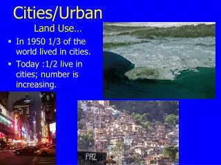
Changes in Cities in the U.S. • Developed Countries: suburbanisation • wealthy move to suburbs • automobiles and roads; ‘American Dream’ • better services • wealthy move to suburbs • counterurbanisation • idyllic settings • cost of land for retirement • slow pace, yet high tech connections to services and markets U.S. population has been moving out of the city centers to the suburbs: suburbanisation and counterurbanisation U.S. intraregional migration during 1990s.
Latin American model • More complex because of influence of local cultures on urban development • Difficult to group cities of the developing world into one or two comprehensive models
Latin American model • In contrast to today’s cities in the U.S., the CBDs of Latin American cities are vibrant, dynamic, and increasingly specialized • A reliance on public transit that serves the central city • Existence of a large and relatively affluent population closest to CBD
Latin American model • Outside the CBD, the dominant component is a commercial spine surrounded by • the elite residential sector • These two zones are interrelated and called the spine/sector • Essentially an extension of the CBD down a major boulevard • Here are the city’s important amenities — parks, theaters, restaurants, and even golf courses • Strict zoning and land controls ensure continuation of these activities, protecting elite from incursions by low-income squatters
Latin American model • Inner-city zone of maturity • Less prestigious collection of traditional colonial homes and upgraded self-built homes • Homes occupied by people unable to participate in the spine/sector • Area of upward mobility
Latin American model • Zone of accretion • Diverse collection of house type, size and quality • Area of ongoing construction and change • Some neighborhoods have city-provided utilities • Other blocks must rely on water and butane delivery trucks for essential services
Latin American model • Zone of peripheral squatter settlements • Where most recent migrants are found • Fringe contrasts with affluent and comfortable suburbs that ring North American cities • Houses often built from scavenged material
Latin American model • Zone of peripheral squatter settlements • Surrounded by landscape bare of vegetation that was cut for fuel and building materials • Streets unpaved, open trenches carry wastes, residents carry water from long distances, electricity is often “pirated” • Residents who work have a long commute • Many are transformed through time into permanent neighborhoods
Changes in Cities in LEDCs • Urbanisation in LEDCs: • driven by changes in economy • the poor live in the suburbs, rich live in CBD • cities struggle to provide jobs and housing • services overtaxed • squatter settlements common • crime on the rise Populations of cities in LEDCs have been surging: urbanisation, migration, natural increase Rio De Janeiro, Brazil