Download
1 / 9
90 likes | 314 Vues
Air Masses and Fronts. An air mass is a large volume of air in the troposphere with similar characteristics of temperature, pressure and moisture as the portion of the Earth’s surface it formed over. T = Tropical air masses form in warm areas.

E N D
An air mass is a large volume of air in the troposphere with similar characteristics of temperature, pressure and moisture as the portion of the Earth’s surface it formed over. T = Tropical air masses form in warm areas. c = Continental air masses are formed over the land. These air masses tend to be dry. P = Polar air masses form in cool areas Air masses tend to be represented by symbols on a map m = Maritime air masses are formed over the water. These air masses tend to be moist. The various symbols for air masses are found on pg. 13 of RT A = Arctic air masses form in very cold areas
Air Masses of North America Continental Arctic (very cool and dry) cA Continental Polar (cool and dry) cP Maritime Polar (cool and moist) mP Maritime Tropical (warm and moist) mT Continental Tropical (warm and dry) cT Maritime Tropical (warm and moist) mT
High and Low Pressure Systems In the Northern Hemisphere, low pressure systems spin counterclockwise. Winds blow towards the low pressure center (convergence). In the Northern Hemisphere, high pressure systems spin clockwise. Winds blow away from the high pressure center (divergence).
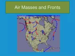
Fronts A front is the interface between air masses. Severe weather conditions are often associated with fronts. RT = Pg. 13 There are four different fronts that represent the areas where air masses meet. Each front is represented by a unique set of symbols and colors.
Cold Front In a cold front, an advancing cold air mass pushes against a warm air mass. The warm air mass is less dense and rises above the cold air mass. The rising air forms large cloud systems associated with severe storms (thundershowers). Rain is usually associated in regions just ahead of, on top of, and behind the cold front.
Warm Front In a warm front, an advancing warm air mass meets acold air mass moving in the same direction. The warm air mass is less dense and rises above the cold air mass. The warm air moves on top of the cold air (like a wedge). A layer of different types of clouds arranged throughout the atmosphere is seen in a warm front. . Rain is usually associated in regions just ahead of the warm front.
Stationary Front In a stationary front, an advancing warm air mass meets an advancingcold air mass moving in opposite directions. The warm air mass is less dense than the cold air mass and rises at the boundary of the front. Sometimes it may take weather patterns a longer time to move across a region due to the opposing movement of the air masses. Cloudy skies and/or rain is usually associated in regions at the stationary front.
Occluded Front In a occluded front, an advancing cold air mass overtakes a warm air mass to meet up with another cold air mass. The warm air is forced above both cold air masses and is responsible for cloud development associated with precipitation. Occluded fronts are associated with the formation of cyclones (low pressure systems). Very low air pressure and stormy conditions are associated in regions at the occluded front.