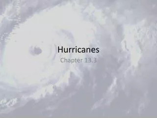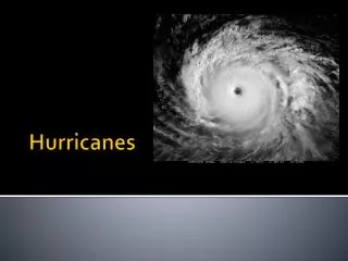
Hurricanes
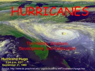
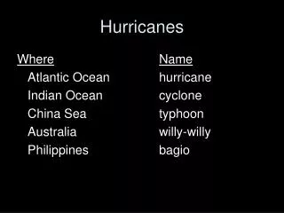
Hurricanes. Hurricanes. Katrina. 1833 deaths 125 billion in damage. Their Origin. Hurricane Prediction: A Mixed Report.

Hurricanes
E N D
Presentation Transcript
Katrina • 1833 deaths • 125 billion in damage
Hurricane Prediction: A Mixed Report • During the past thirty years there has been substantial in improvement is hurricane track forecasts as computer models improved and more data became available to describe their environment. • Over the same period only minimal improvement is hurricane intensity forecasts.
Substantial Promise • The use of higher resolution prediction and better data around and in hurricanes should result in better intensity predictions. 15-km grid spacing 1.67 km grid spacing
Katrina 48-h Before: Virtually a Perfect Forecast of Track
Katrina • But the intensity was not well forecast until the day before…. • Friday’s intensity prediction (storm hit Monday AM) HURRICANE KATRINA DISCUSSION NUMBER 12 NWS TPC/NATIONAL HURRICANE CENTER MIAMI FL 11 AM EDT FRI AUG 26 2005 FORECAST POSITIONS AND MAX WINDS INITIAL 26/1500Z 25.1N 82.2W 70 KT 12HR VT 27/0000Z 25.2N 83.1W 75 KT 24HR VT 27/1200Z 25.5N 84.3W 80 KT 36HR VT 28/0000Z 26.2N 85.2W 85 KT 48HR VT 28/1200Z 27.1N 85.9W 90 KT 72HR VT 29/1200Z 29.5N 86.3W 100 KT 96HR VT 30/1200Z 34.5N 83.5W 35 KT...INLAND 120HR VT 31/1200Z 40.5N 77.0W 25 KT...DISSIPATING INLAND
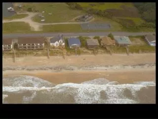
URGENT - WEATHER MESSAGE • NATIONAL WEATHER SERVICE NEW ORLEANS LA • 1011 AM CDT SUN AUG 28 2005 • ...DEVASTATING DAMAGE EXPECTED... • .HURRICANE KATRINA...A MOST POWERFUL HURRICANE WITH UNPRECEDENTED • STRENGTH...RIVALING THE INTENSITY OF HURRICANE CAMILLE OF 1969. • MOST OF THE AREA WILL BE UNINHABITABLE FOR WEEKS...PERHAPS LONGER. AT • LEAST ONE HALF OF WELL CONSTRUCTED HOMES WILL HAVE ROOF AND WALL • FAILURE. THE MAJORITY OF INDUSTRIAL BUILDINGS WILL BECOME NON FUNCTIONAL. • PARTIAL TO COMPLETE WALL AND ROOF FAILURE IS EXPECTED. ALL WOOD • FRAMED LOW RISING APARTMENT BUILDINGS WILL BE DESTROYED. CONCRETE • BLOCK LOW RISE APARTMENTS WILL SUSTAIN MAJOR DAMAGE...INCLUDING SOME • WALL AND ROOF FAILURE. • HIGH RISE OFFICE AND APARTMENT BUILDINGS WILL SWAY DANGEROUSLY...A • FEW TO THE POINT OF TOTAL COLLAPSE. ALL WINDOWS WILL BLOW OUT. • AIRBORNE DEBRIS WILL BE WIDESPREAD...AND MAY INCLUDE HEAVY ITEMS SUCH • AS HOUSEHOLD APPLIANCES AND EVEN LIGHT VEHICLES. SPORT UTILITY • VEHICLES AND LIGHT TRUCKS WILL BE MOVED. THE BLOWN DEBRIS WILL CREATE • ADDITIONAL DESTRUCTION. PERSONS...PETS...AND LIVESTOCK EXPOSED TO THE • WINDS WILL FACE CERTAIN DEATH IF STRUCK. • POWER OUTAGES WILL LAST FOR WEEKS...AS MOST POWER POLES WILL BE DOWN • AND TRANSFORMERS DESTROYED. WATER SHORTAGES WILL MAKE HUMAN SUFFERING • INCREDIBLE BY MODERN STANDARDS. • THE VAST MAJORITY OF NATIVE TREES WILL BE SNAPPED OR UPROOTED. ONLY • THE HEARTIEST WILL REMAIN STANDING...BUT BE TOTALLY DEFOLIATED. FEW • CROPS WILL REMAIN. LIVESTOCK LEFT EXPOSED TO THE WINDS WILL BE • KILLED.