Download
1 / 20
200 likes | 365 Vues
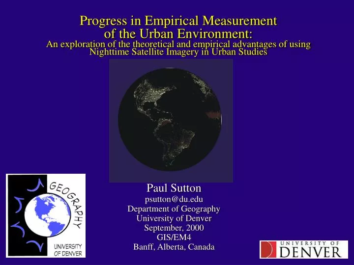
Progress in Empirical Measurement of the Urban Environment: An exploration of the theoretical and empirical advantages of using Nighttime Satellite Imagery in Urban Studies. Paul Sutton psutton@du.edu Department of Geography University of Denver September, 2000 GIS/EM4

E N D
Progress in Empirical Measurement of the Urban Environment:An exploration of the theoretical and empirical advantages of using Nighttime Satellite Imagery in Urban Studies Paul Sutton psutton@du.edu Department of Geography University of Denver September, 2000 GIS/EM4 Banff, Alberta, Canada
Outline • Motivation: Why Gather Information about the Urban Environment? • Background: What datasets exist and where do they come from? • Distinctions between Ground & Image based measures • Potential of Satellite imagery for monitoring Urban Environment • New & Old Theories of Urban Form and Structure • Models using Nighttime Imagery to estimate Population Parameters • Theoretical and Empirical Advantages of these methods • Future Directions • Summary/Conclusions
More than half the world’s population lives in urban areas and this fraction is growing Social, Economic, and Behavioral Demographic Data are the major gaps to be filled in globally integrated geo-information Existing Information is degrading due to increasing human mobility, and the fact that a growing proportion of the earth’s population live in developing countries which can’t afford to conduct accurate censuses Spatially referenced demographic information is a vital component of studies of: Hazard Planning and Response, Sustainability and Development Issues, and countless other cross-disciplinary investigations MotivationWhy gather information about the Urban Environment?
BackgroundWhat datasets exist and where do they come from? Global Population Datasets Gridded Population of the World (GPW): A Single Variable Model Derived from National Statistical Offices of the world LandScan: A Multiple Variable Model Derived from digital cartographic products and imagery Integrated Global Environmental and Infrastructure Datasets ISCGM’s Global Map Global Spatial Data Infrastructure (GSDI) (Landcover, Transportation networks, Admin Boundaries, Lakes, Rivers, Elevation, Vegetation) United Nations Geographic Database(does not exist yet) Social and/or Environmental Data? Potential for Symbiotic relationships with existing data
Distinctions between ground based & map or imagery based data Map & Imagery Based Data Derived from digital cartographic products and remotely sensed imagery Primarily physical in nature e.g. elevation, landcover, temperature, etc. Inexpensive to acquire, maintain, update, and provide Variable spatial and temporal resolution Obtained by various institutions and not necessarily an ‘official’ measure Ground Based Data Derived from Enumeration, Surveys and Administrative Records Primarily Social, Economic, and Behavioral Demographic information Expensive to acquire, maintain, update, and provide Coarse spatial and temporal resolution Usually obtained by governments and represents ‘official’ figures
Potential contributions of remotely sensed imagery to monitoring urban environment A diverse spectrum of remotely sensed information is available including: Nighttime Satellite Imagery, vegetation, Landcover, ‘greenness’, local and absolute elevation, etc. Models that truly integrate diverse sources of this kind of information (e.g. use multiple sensors, spatial analysis, and cartographic info) to estimate urban and demographic information have not been fully explored. The organizing framework that GIS implicitly provided allows for the development and validation of models with the potential to independently measure many variables including population density, income, economic activity, urban growth, etc. (fertility from space?) Establishment of the validity and independence of these models will improve the spatial and temporal resolution of data coverage, and inform sampling strategies for ground based measurements in areas with limited resources
Classical Models of Urban Form Weaknesses Depend on subjective classification Difficult to measure for a given city Not Very General Strengths Describe Complex Spatial Patterns and Processes Prospects of Image Based Models Derived from Easy to make Measurements that Can be obtained objectively to produce general Models of Urban Form Challenges Describe Complex Spatial Patterns and Processes
Classical Models of Urban Structure Examples: Clark’s Exponential Decay of Pop Den from CBD Newling’s theories on evolution of Exp Decay Nordbeck’s Ln(area) vs. Ln(population) relationship Utility: Measure parameters for areas with known data Identify general variations in those parameters Extend models to areas without known data
Example of Parameterization Process For Ln(area) vs. Ln(pop) for world cities • Scatterplot of All Cities/Urban Clusters of the World w/ Known Populations • All Cities (N= 1,404): • Ln(pop) = .850* Ln(Area) + 9.107 R2 = 0.68 • High Income Cities (N=471): • Ln(pop) = 1.065*Ln(Area) + 7.064 R2 = 0.77 • Medium Income Cities (N=575): • Ln(pop) = 1.011*Ln(Area) + 8.174 R2 = 0.78 • Low Income Cities (N=358): • Ln(pop) = 0.989*Ln(Area) + 8.889 R2 = 0.80 • Venezuelan Cities (N=15): • Ln(pop) = 1.164*Ln(pop) + 6.475 R2 = 0.84
A Nighttime Satellite Image of DenverWhat Urban Form and/or Structure can be seenin this single band gray-scale image?
Using Nighttime Satellite imagery to estimate intra-urban population density • Allocate aggregate estimate of total city population to pixels within urban cluster (utilizing existing urban theory) • Use linearly proportional relationship between light intensity and population density (could be improved with non-linear models and/or additional bands of remotely sensed data) • Compare to residence and employment based measures of population density
Actual, Modeled, and Smoothed Representations of Minneapolis
‘Ambient’ or Temporally Averaged Population Density • Census data is typically a residence based measure of population density • People, work, shop, go to school, and entertain & transport themselves outside of the home • Is a temporally averaged measure of population density useful? • (e.g. for a given 1 km2 area with 600 people in it for 8 hrs, 300 in in the next 8 hours, and 0 people in it the last 8 hours it has a temporally averaged population density of 300 persons/km2)
Are DMSP OLS based estimates of population density a temporally averaged measure of population density?
Theoretical and Empirical Benefits of Image based Measures of the Urban Environment • Theoretical Benefits: Theory based on physical measures are more general Image based and classical models mutually inform one another • Empirical Benefits: Imagery is available globally at finer spatial & temporal resolution Image-based models naturally integrate into other environmental models that interact with urban processes
Future Directions • LandScan and GPW represent a bifurcation in methodology for obtaining social, economic, and behavioral demographic information that should be encouraged • GSDI and United Nations Geographic Database potentially represent the same phenomena at a larger scale • Independence between image based and ground based measurements should be fostered for many reasons including: symbiosis, validation, sampling strategy development, and Institutional considerations • Resolve Scale Issues at Theoretical, Institutional, and Technical levels
Summary/Conclusions Nighttime Satellite imagery from DMSP OLS can be used to: 1) Estimate the population of urban agglomerations around the world 2) Estimate intra-urban temporally averaged measures of population density This example only scratches the surface of possibilities For example: How well could a model perform if it included 3-D building volume from DEMs, ‘Greenness’, and Transportation Infrastructure? Global Spatial Data Infrastructure and United Nations Geographic Database development efforts should benefit from this potential