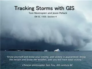
Radio Tracking Deer and GIS Software
Radio Tracking Deer and GIS Software. By Brian Foley Dept of Computer Science UW-Platteville WI. Global Information Systems . Revolutionizes the study of wildlife animals GIS Software allows researchers to see patterns and visualize data to give them a better understanding of the facts.

Radio Tracking Deer and GIS Software
E N D
Presentation Transcript
Radio Tracking Deer and GIS Software By Brian Foley Dept of Computer Science UW-Platteville WI
Global Information Systems • Revolutionizes the study of wildlife animals • GIS Software allows researchers to see patterns and visualize data to give them a better understanding of the facts.
Topics to Cover • Chronic Wasting Disease (CWD) • UW-Madison CWD White-Tailed Deer Research Project • GIS Software such a Location Of A Signal (LOAS) and Arcview
What is CWD? • CWD is related to a group of diseases known as Transmissible Spongiform Encephalopathies (TSEs). • TSEs are fatal diseases of the nervous system that creates lesions in the brain. • The causative agent is a modified Protein called a Prion which is found in the nervous system and lymphatic tissues.
Other Examples of TSEs • Scrapie in sheep • Bovine Spongiform Encephalopathy (BSE) in cattle. Also known as “Mad Cow Disease”. • Creutzfeldt-Jakob disease in humans
Symptoms of Deer with CWD • Become lean through loss of flesh • Display of Abnormal Behavior • Loss of Bodily Functions • Eventually Death
Concerns of CWD • It is unknown whether humans can become infected with CWD. • To be safe, people should not consume or handle the brain, eyes, tonsils, and spinal cord. • The meat should be de-boned before consumption.
On February 28, 2002, three deer in Mount Horeb WI were found to have CWD. White-Tailed deer appear more susceptible to CWD than elk and mule deer. Much more deer per square mile in WI CWD in Wisconsin
CWD White-tailed Deer Research Project • Seeks to determine the movement patterns of deer. • Collect data to determine home-ranges and dispersal movements. • Examine behavior that may contribute to the spread of the disease • By learning the above, it may be possible to determine the rate at which CWD spreads throughout the landscape.
Gathering of Data • VHF radio collars are placed on deer • Technicians track the signals • LOAS Determines The Location of Deer • Arc View uses the results of LOAS to make other unique comparisons
Deer are captured using various techniques VHF radio collars are placed on deer Each collar is set to a unique frequency Deer are tracked through radio telemetry Deer are tracked 3-10 times per week at various times of the day Radio Collars
Locating A Specific Animal • Technicians are sent to at least 4 waypoints • The frequency of a specific deer is dialed-in • Once a signal is detected, data is recorded
Data To Be Recorded • Direction of the signal in degrees (this is called a “Bearing”) • Strength of a signal • Whether or not an animal is active • Temp, precipitation, date, time of bearing, and relative wind speed
LOAS requires at least 2 “Bearings” All “Bearings” must be taken within 20 minutes of each other A minimum of 6 hours must pass between sets of bearings “The Error Polygon” needs to be less than 50,000 square meters “Bearing” Constraints
The Error Polygon • “The polygon formed where all the bearings intersect” • The more “Bearings” take, the smaller the polygon becomes. • The smaller the Error Polygon, the more accurate LOAS becomes • The Deer’s location is within this polygon
A Problem Called “Bounce” • Occurs in Hilly Terrain • Signal comes from behind the direction the technician is facing • Beacons to test the effects of Bounce
Global Coordinate System • Called the “Universal Transverse Mercator” • Developed by the Dept. Of Defense • Divides the world into 60 different North-South longitudinal zones
Problem For UW-Madison Research Project • Radio-Collared deer in Iowa and Dane Cty • Zone 15 and 16 meet in Iowa Cty • Wisconsin Transverse Mercator (WTM) is developed by the Wisconsin Department of Natural Resources
LOAS Software • Only used for estimating locations • A minimum of 2 “Bearings” needed • Incorporates graphical representations • Works hand in hand with Arc View
Data Spreadsheet • Spreadsheet of the data to be used by LOAS. The user may modify the data by double clicking a cell and changing the contents.
Results Spreadsheet • This file is read only, however it can be copied into other programs.
Error Log • If LOAS encounters any kind of an error in processing, the errors are listed here. Examples include bearing lines that do not intersect or data of the wrong type.
Legend • This will give alternative graphing options such as changing the way lines and points are displayed.
PolygonID • Data of the click ellipses appear here
LOAS and Databases • Can open database files and text files • Converts a text file into a character based database • Able to link databases Example: Parent file may contain bearing data while the child file may contain receiver locations
Selecting Bearing Estimators to Calculate Locations • 7 different estimators • Each estimator differs in accuracy and required data • Desired estimator depends on many factors *desired accuracy *number of bearings taken *quality of bearings
7 Bearing Estimators • Maximum Likelihood Estimator • Huber Estimator • Andrew Estimator • Best Biangulation • Arithmetic Mean • Geometric Mean • Harmonic Mean
Maximum Likelihood Estimator • Finds the least angular error • Iterative algorithm • No outliers
Huber and Andrew Estimators • Known as the “M” Methods • Bearing outliers exist • Recursive iterations • 5 bearings are needed
Best Biangulation Estimator • Used if only 2 bearings are available • Picks the angle closest to 90 degees
Arithmetic Mean • The old standby • Adds all coordinate points and averages • Can be “skewed”
Logarithmic method is used More accurate than Arithmetic Mean Still outlier sensitive Similar to Arithmetic and Geometric Mean Less outlier sensitive Geometric Mean | Harmonic Mean
LOAS Graphics • Label use • Font and Color • Point and Line properties
LOAS Data • Automatically creates other files • Results sent to spreadsheet • Filtering of Data is allowed • Sorting Capability
ArcView • Allows user to determine other relationships besides location • Creates shapefiles or maps • Comes with 8 CD-ROMS • Multimedia links can be incorporated • Many additional extensions
Other ArcView Extensions • ArcView Spatial Analyst • ArcView 3D Analyst • ArcView Image Analysis • ArcView Tracking Analyst • ArcView StreetMap • ArcView Movement Analysis
UW-Madison CWD Research Project • Spatial Analyst = allows users to analyze specific cell based raster maps, and to infer new information based on current data • Movement Analysis = used to analyze movement data
Movement Extension • Calculates Home-Range • Kernel Home-Range and MCP Home-Range • Calculates distances
Kernel Home Range View • Utilization distribution grid • A Shapefile for each probability is created • Calculations for each probability is shown • Research Project uses 95% probabilities
Other ArcView Calculations • Center of a deer’s home-range • Variance • Mean distance of dispersal • Distance traveled daily in meters