Download
1 / 18
180 likes | 322 Vues
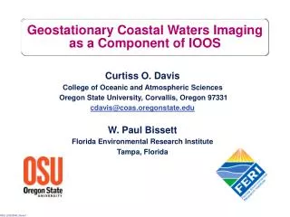
GOES-R Coastal Waters Imaging and the COAST Risk Reduction Activities. Curtiss O. Davis and Mark Abbott College of Oceanic and Atmospheric Sciences Oregon State University, Corvallis, Oregon 97331 cdavis@coas.oregonstate.edu. Presentation Outline.

E N D
GOES-R Coastal Waters Imaging and the COAST Risk Reduction Activities Curtiss O. Davis and Mark Abbott College of Oceanic and Atmospheric Sciences Oregon State University, Corvallis, Oregon 97331 cdavis@coas.oregonstate.edu
Presentation Outline • Hyperspectral Environmental Suite-Coastal Water Imaging capability (HES-CW) is planned for GOES-R series. • First ocean color measurements from geostationary orbit to provide frequent imaging of coastal waters. • Why HES-CW given VIIRS? • Example Products • The Coastal Ocean Applications and Science Team (COAST) and planned Risk Reduction Activities • Summary
Visible Infrared Imaging Radiometer Suite (VIIRS) • Being built by Raytheon SBRS • SeaWiFS and MODIS heritage • First flight on NPOESS Preparatory Project (NPP) in 2008 then NPOESS satellites starting in 2011 • Seven ocean color channels and 2 SST channels • Approximately 1 km GSD ocean color • 742 m GSD and Nadir, 1092 m at +/- 850 km, 1597m at End of Scan (+/- 1500 km) • Designed to meet global ocean imaging requirements at 1 km GSD • Maximum revisit frequency of twice a day at 1030 and 1530
Why HES-CW given VIIRS? • Tides, diel winds (such as the land/sea breeze), river runoff, upwelling and storm winds drive coastal currents that can reach several knots. Furthermore, currents driven by diurnal and semi-diurnal tides reverse approximately every 6 hours. • VIIRS daily sampling at the same time cannot resolve tides, diurnal winds, etc. • HES-CW Can resolve tides from a geostationary platform and will provide the management and science community with a unique capability to observe the dynamic coastal ocean environment. • HES-CW will provide higher spatial resolution (300 m vs. 1000 m) • HES-CW will provide additional channels to measure solar stimulated fluorescence, suspended sediments, CDOM and improved atmospheric correction. Example tidal cycle from Charleston, OR. Black arrows VIIRS sampling, red arrows HES-CW sampling. These improvements are critical for the analyses of coastal waters.
Modeled HES-CW (250 m) HES-CW higher spatial resolution critical to monitor complex coastal waters MODIS 1 km water clarity
Fluorescence provides better phytoplankton measurements in optically-complex coastal waters • MODIS Terra l2 scene from 3 October 2001. • The ratio of Fluorescence Line Height (FLH) to chlorophyll is a good indicator of the health of the phytoplankton population. • FLH separates chlorophyll from suspended sediments in the Columbia River Plume. • Fluorescence line height not available from VIIRS.
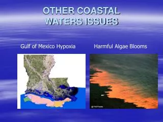
Monterey Bay Harmful Algal Bloom • Harmful Algal Bloom in Monterey Bay threatens beach areas. • Bloom near coast and on the order of 2 x 5 km would not be resolved in 1 km VIIRS data. • Additional channels on HES-CW aid bloom identification. • PHILLS-2 airborne hyperspectral data from Paul Bissett, Florida Environmental Research Institute. (October 2002 Ceratium spp. bloom)
COAST and Risk Reduction Activities • The Coastal Ocean Applications and Science Team (COAST) was created in August 2004 to support NOAA to develop coastal ocean applications for HES-CW: • Mark Abbott, Dean of the College of Oceanic and Atmospheric Sciences (COAS) at Oregon State University is the COAST team leader, • COAST activities are managed through the Cooperative Institute for Oceanographic Satellite Studies (CIOSS) a part of COAS, Ted Strub, Director • Curtiss Davis, Senior Research Professor at COAS, is the Executive Director of COAST. • Initial activity to evaluate HES-CW requirements and suggest improvements • Paul Menzel Presented GOES-R Risk Reduction Program at the first COAST meeting in September 2004 and invited COAST to participate. • Curt Davis and Mark Abbott presented proposed activities in Feb. 2005. • CIOSS/COAST invited to become part of GOES-R Risk Reduction Activity beginning in FY 2006. • Proposal Submitted to NOAA Sept 6, 2005.
Risk Reduction Activities:Principal Roles of Co-Investigators • Curtiss Davis, program management, calibration, atmospheric correction • Mark Abbott, COAST Team Leader • Ricardo Letelier, phytoplankton productivity and chlorophyll fluorescence, data management • Peter Strutton, coastal carbon cycle, Harmful Algal Blooms (HABs) • Ted Strub, CIOSS Director, coastal dynamics, links to IOOS COAST Participants: • Bob Arnone, NRL, optical products, calibration, atmospheric correction, data management • Paul Bissett, FERI, optical products, data management • Heidi Dierssen, U. Conn., benthic productivity • Raphael Kudela, UCSC, HABs, IOOS • Steve Lohrenz, USM, suspended sediments, HABs • Oscar Schofield, Rutgers U., product validation, IOOS, coastal models • Heidi Sosik, WHOI, productivity and optics • Ken Voss, U. Miami, calibration, atmospheric correction, optics NOAA/ORA • Menghua Wang, atmospheric correction • Mike Ondrusek, calibration, MOBY
Calibrated radiances at the sensor Raw sensor data Water Leaving Radiances Calibration Atmospheric Correction Optical properties Algorithms In-Water Optical Properties now-cast and forecast models Applications and products Data assimilation into models Product models and algorithms Education and outreach Users HES-CW Data flow and Risk Reduction Activities
Approach to Algorithm Development • Directly involve the ocean color community which has extensive algorithm development experience with SeaWiFS and MODIS • NASA funded science teams developed, tested and validated calibration, atmospheric correction and product algorithms • Additional product development and testing funded by U. S. Navy • Documented in Technical reports, publications and Algorithm Theoretical Basis Documents (ATBDs) • Algorithms are continuously evaluated and updated; SeaWiFS and MODIS data routinely reprocessed to provide Climate Data Records with latest algorithms. • Design program to assure compatibility of HES-CW products with VIIRS • VIIRS algorithms based on MODIS ATBDs • Similar calibration and atmospheric correction approaches • Use the same ocean calibration sites for vicarious calibration • Initial plans and algorithms based on SeaWiFS and MODIS experience modified to fit HES-CW in geostationary orbit. • Advanced algorithms tested and implemented when available. • Early tests planned using airborne hyperspectral data.
Proposed Experiments to Collect Simulated HES-CW data • There are no existing data sets that include all the key attributes of HES-CW data: • Spectral coverage (.4 – 2.4 mm) • High signal-to-noise ratio (>300:1 prefer 900:1, for ocean radiances) • High spatial resolution (<150 m, bin to 300 m) • Hourly or better revisit • Propose field experiments in FY2006-2008 to develop the required data sets for HES-CW algorithm and model development. • Airborne system: • Hyperspectral imager that can be binned to the HES-CW bands • Flown at high altitude for 20 km x 20 km scenes every 30 min • Endurance to collect repeat flight lines every half hour for up to 6 hours • Spectroscopy Aerial Mapping System with On-Board Navigation (SAMSON) Hyperspectral Imager (Florida Environmental Research Inst.) • Propose three experimental sites: • 2006 Monterey Bay (late August, coastal upwelling, HABs) • 2007 New York/Mid Atlantic Bight (August, river input, urban aerosols) • 2008 Mississippi River Plume (Sediment input, HABs)
Summary • HES-CW will provide an excellent new tool for the characterization and management of the coastal ocean. • Risk Reduction activities focus on calibration and algorithm development; • Initially provide SeaWiFS and MODIS heritage calibration and algorithms; • 2006-2008 field experiments to develop example HES-CW data for • algorithm development and testing, • Coordination with IOOS for in-situ data and coastal ocean models, • Demonstrate terabyte web-based data system. • Major focus on developing advanced algorithms that take advantage of HES-CW unique characteristics. • Efforts coordinated with NOAA ORA, NMFS and NOS with a focus on meeting their operational needs. Special thanks to Ted Strub, Amy Vandehey and the COAST for their hard work getting this program started. Thanks to NOAA for funding and particularly to Stan Wilson, John Pereira, Eric Bayler and Paul Menzel for their support and guidance.
Frequency of Sampling and Prioritizing Goal Requirements • Threshold requirement is to sample all Hawaii and Continental U. S. coastal waters once every three hours during daylight • Plus additional hourly sampling of selected areas • Goal requirement is hourly sampling of all U.S. coastal waters is strongly recommended, for cloud clearing and to better resolve coastal ocean dynamics. • Goal requirements compete with each other, e.g. higher spatial resolution makes it harder to increase sampling frequency or SNR. • COAST top priority goals are: • Higher frequency of sampling • Goal channels for atmospheric correction • Hyperspectral instead of multispectral HES-CW built to the threshold requirements will be a dramatic improvement over present capabilities for coastal imaging.
Risk Reduction Activities • Approach to Algorithm Development • Experience with SeaWiFS and MODIS • Field Experiments to collect prototype HES-CW data • Planned Risk Reduction activities: • Calibration and vicarious calibration • Atmospheric correction • Optical properties • Phytoplankton chlorophyll, chlorophyll fluorescence and productivity • Benthic productivity • Coastal carbon budget • Harmful algal blooms • Data access and visualization • Education and public outreach
Proposed Experiments to collect simulated HES-CW data (2 of 2) • Experimental Design • Choose sites with IOOS or other long term monitoring and modeling activities • Intensive effort for 2 weeks to assure that all essential parameters are measured: • Supplement standard measurements at the site with shipboard or mooring measurements of water-leaving radiance, optical properties and products expected from HES-CW algorithms, • Additional atmospheric measurements as needed to validate atmospheric correction parameters, • As needed, enhance modeling efforts to include bio-optical models that will utilize HES-CW data. • Aircraft overflights for at least four clear days and one partially cloudy day (to evaluate cloud clearing) during the two week period. • High altitude to include 90% or more of the atmosphere • 30 min repeat flight lines for up to 6 hours to provide a time series for models and to evaluate changes with time of day (illumination, phytoplankton physiology, etc.) • All data to be processed and then distributed over the Web for all users to test and evaluate algorithms and models.