Download
1 / 70
710 likes | 1.2k Vues
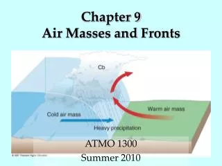
Chapter 9 Air Masses and Fronts. ATMO 1300 Summer 2010. Air Mass. A large body of air in which there are similar horizontal temperature and moisture properties. Properties largely acquired from underlying surface Air masses can cover thousands of miles

E N D
Chapter 9Air Masses and Fronts ATMO 1300 Summer 2010
Air Mass • A large body of air in which there are similar horizontal temperature and moisture properties. • Properties largely acquired from underlying surface • Air masses can cover thousands of miles • Air masses form when air stagnates over one region for a long time • Longer the air remains over an area, the more likely it will acquire the characteristics of the underlying surface
Air Mass • Air mass over cold ground Cold and dry… Example winter time in Canada • Air mass over water More moist How does water temp affect moisture? Example: Gulf of Mexico
Air Mass • Temperature properties: sensible heating through conduction and eventually convection • Moisture properties: acquires water vapor through evaporation
Air Mass Classification • Temperature: Warm – Tropical, within about 30˚of equator Cold – Polar, poleward of 60˚ Very cold – Arctic, formed over the arctic • Moisture: Dry – Continental, formed over large land masses Moist – Maritime, formed over oceans
Air Mass Designation • cP = Continental Polar • cT = Continental Tropical • mP = Maritime Polar • mT = Maritime Tropical • A = Arctic air masses, much colder than other classes
Source Region • A region on the earth where air masses tend to form. • Need a uniform surface. • Light winds are preferable.
Source Region • Notice that most air masses originate under regions of surface high pressure • Stagnate air • Not much wind = little pressure gradients • Also remember stability… Tropical air masses are in general less stable (more unstable) than polar air masses
Maritime Polar (mP) • Forms over the oceans at high latitudes • Moist • Cold • Can contribute to significant snowfall events in mid-Atlantic • Nor’easters • Low pressure systems draw air counter clockwise around them, bringing mP air from the Atlantic toward New England
Continental Polar (cP) • Forms over the northern continental interior (e.g., Canada, Alaska) • Long, clear nights allows for substantial radiational cooling (stability?) • Assisted by snowpack • Dry • Cold • Figure from apollo.lsc.vsc.edu/classes/met130
Continental Polar (cP) • Winter time air cP air masses are cold and dry • They require long cold, clear nights • Strong radiational cooling allows surface temperatures to fall quickly • Air above the surface is not cooled as quickly which can lead to an inversion (temperature increasing with height) • When cP air masses are formed in the summer they are generally cool and dry
Arctic (A,cA) • Similar to cP, but forms over very high latitudes (arctic circle) • Dry • Extremely cold • Not very deep (less than 600 m) • Little vertical motion and little precipitation • Responsible for record cold temperatures over the mid-latitudes • Figure from apollo.lsc.vsc.edu/classes/met130
Continental Tropical (cT) • Forms over southwest U.S. & Northern Mexico • Source region includes west Texas • Dry, limits cloud formation • Warm • Limited water bodies and vegetation limits effect of evaporation and transpiration
Maritime Tropical (mT) • Forms over Gulf of Mexico as well as subtropical Atlantic and Pacific Oceans • Moist • Warm • Responsible for hot humid weather across the southern US during the summer • Figure from apollo.lsc.vsc.edu/classes/met130
Air Mass Modification • Air masses can be modified once they leave their source region. • Temperature & moisture content can increase or decrease • So how are air masses modified?
Heat exchanges with the surface The greater the difference between the properties of the air mass and the underlying surface, the greater the exchange rate Exchanges of moisture is greatest when air mass is dry and the surface is wet Example: cold cP air mass moves over a warm body of water, Large temperature difference allows for rapid evaporation. The moisture content is increased (dewpoint goes higher) and we get saturation and fog Example is common over the great lakes Air Mass Modification
Air Mass ModificationFigure from ww2010.atmos.uiuc.edu • Move over a large body of water Fig. 9-12, p. 264
Air Mass ModificationFigure from ww2010.atmos.uiuc.edu • Move over warmer or colder ground
Air Mass ModificationFigure from www.usatoday.com/weather/wdnslope.htm • Move over a mountain range
Air Mass Modification • Stability of the air mass can also be modified • Changing the environmental temperature profile • Increasing or decreasing the temperature of the air near the surface alters the environmental temperature profile
General Flow of Air in the Upper Atmosphere • We know that the winds in the upper-atmosphere (troposphere) flow in a wave-like pattern with troughs and ridges • These features move cold air equatorward and warm air poleward • The northern hemisphere is typically encircled by several of these waves at any given time • These waves are called long-waves or Rossby Waves (named for Carl Gustav Rossby)
General Circulation of the Atmosphere • Just like electromagnetic waves, waves in the atmosphere have a wavelength, amplitude and period • Describing the movement of these waves is a key component in weather forecasting (remember the vertical motions associated with troughs and ridges) • Small amplitude waves result in a nearly zonal flow (west to east flow pattern). The flow is nearly parallel to lines of latitude • In this regime cold air tends to remain poleward
General Circulation of the Atmosphere • Meridional flow pattern means highly amplified troughs and ridges • In this pattern, cold air flows toward the equator and warm air flows poleward
General Circulation of the Atmosphere • Superimposed on the long-waves or Rossby waves are smaller features called short-waves • These features travel quickly through the Rossby waves • Difficult to observe and track, adds to uncertainty in weather forecasts
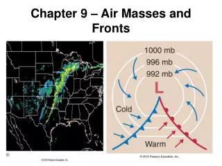
Fronts • Air masses move from source region through advection • Air masses do not readily mix together • Front – A boundary between two different air masses • Can be hundreds of miles long
Fronts • Sloping surface that separates two air masses • Area where the front meets the ground is called the frontal zone, which is what is depicted on surface weather maps • Front is not a line, but a zone a few miles across where the air mass properties change (gradients)
Fronts • Frontogenesis – strengthening of gradients along a front • Frontolysis – weakening of gradients along a front
Types of Fronts • Cold Front • Warm Front • Stationary Front • Occluded Front
Cold Front • Cold air advances, replaces warm air at the surface • Change in wind direction/speed • Minimum in atmospheric pressure Fig. 9-14, p. 266
Cold Front Cross Section • A front is a 3-D boundary • Front slopes back over the cold air mass • Warm, less dense air is lifted • Clouds/precipitation associated with a front depend on stability and moisture • Sharp vertical motion at cold front can force thunderstorm activity Fig. 9-15, p. 266
Typical Cold Front Weather Weather Before While After Windssoutherly gusty/shifting northerly Temperaturewarm sudden drop steady fall Pressuresteady fall minimum, sharp risesteady rise Clouds cirrus, cirrostratus, tcu,cb tcu or cb cumulus Precipitation showers tstms, heavy shwrs clearing heavy snow Dewpoint high sharp drop lowering
Slope of a Front • Depends on temperature and wind differences between the two air masses • Shallow vs. steep slope http://twister.ou.edu/DensityCurrent/D2L01a.gifs/D2L01a.html http://www.mesonet.ttu.edu/cases/GravityWaves_092809/20090928.html
Warm Front • Warm air advances • Replaces the cold air at the surface • Change in wind direction/speed • Cold air mass retreating toward the north • Typically also a change in dewpoint Fig. 9-17, p. 268
Warm Front Cross Section • Front slopes back over the cold air mass • Slope is more gentle than with a cold front (less thunderstorm activity) • Warm, less dense air lifted over the cold air (called overrunning) • Clouds/precipitation depend on moisture and stability, usually follow a set progression with an increase in altitude • Responsible for a lot of hazardous winter weather Fig. 9-18, p. 269
Typical Warm Front Weather Weather Before While After Windssouth-southeast light variable south-southwest Temperature cool/cold steady rise warmer then steady Pressurefalling leveling offslight rise Clouds stratus/fog stratus type Towering cu (spring/summer), clearing Precipitation light precip little to none showers, tstm Dewpoint steady rise steady rise then steady